Hale, Greater Manchester facts for kids
Quick facts for kids Hale |
|
|---|---|
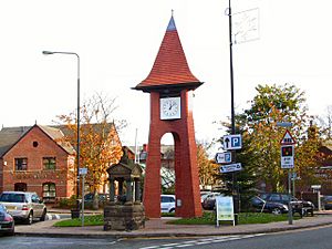
 Hale Millennium clock tower |
|
| Population | 15,315 (2011) |
| OS grid reference | SJ769867 |
| Metropolitan borough | |
| Metropolitan county | |
| Region | |
| Country | England |
| Sovereign state | United Kingdom |
| Post town | Altrincham |
| Postcode district | WA15 |
| Dialling code | 0161 |
| Police | Greater Manchester |
| Fire | Greater Manchester |
| Ambulance | North West |
| EU Parliament | North West England |
| UK Parliament |
|
Hale is a town located in Greater Manchester, England. It's a part of the Trafford area. In 2011, about 15,315 people lived there. Hale is close to Altrincham and about 9 miles (14 km) southwest of the big city of Manchester.
Hale has a long history. It was first mentioned in the Domesday Book in 1086. For a long time, it was mostly a farming area. Over the years, Hale grew, and a nearby place called Hale Barns became its own separate village. Hale used to be part of Cheshire county.
Today, Hale is known as one of the wealthiest areas in Greater Manchester. It's similar to other rich towns like Wilmslow and Alderley Edge in Cheshire. These areas have some of the most expensive homes outside of London.
Contents
Hale's History: From Farms to a Town
The name "Hale" comes from an old English word, halh. This word means a "nook" or "shelter." This makes sense because the area has natural features that offer protection.
The earliest record of Hale is from the Domesday Book in 1086. But there's some evidence that people called Saxons settled here much earlier, around the 600s. The Domesday Book shows that before the Norman Conquest, a Saxon lord named Ælfward owned Hale. After the Normans took over England, a Norman baron named Hamon de Massey got control of Hale. His family ruled this area until the mid-1300s. During these early times, Hale was mostly a farming community.
Hale grew a lot during the Middle Ages. By the mid-1400s, it was so important that a special barn for collecting taxes (called a tithe barn) was built in Hale Barns. The taxes collected from Hale were more than double those from any other nearby town! Because Hale grew so much, Hale Barns became its own village.
A big change happened in the mid-1800s when the Cheshire Midland Railway came to Hale. A train station opened in 1862, first called Peel Causeway, then renamed Hale in 1902. The railway helped Hale change from a farming village into a place where people who worked in the city could live and travel from.
How Hale is Governed
From 1900 to 1974, Hale was its own special district called the Hale Urban District. But in 1974, the government changed how local areas were run. Hale became part of the new Metropolitan Borough of Trafford in Greater Manchester.
Hale Central is a local area (called a ward) within Trafford. It has three out of 63 seats on the Trafford Borough Council. As of 2012, all three of these seats were held by the Conservative Party. The people who represent Hale Central on the council are Chris Candish, Alan Mitchell, and Patricia Young.
Hale is also part of a larger area called the Altrincham and Sale West Constituency. This area sends one person to the House of Commons in London. Since 1997, this person has been Graham Brady, who is also from the Conservative Party.
Hale's Location and Surroundings
 |
Altrincham | Timperley | Roundthorn Industrial Estate |  |
| Bowdon | Benchill | |||
| Rostherne | Ashley | Hale Barns |
Hale is located southeast of Altrincham. To its east is Hale Barns, and to its west is Bowdon. The River Bollin forms Hale's southern border, and Altrincham Golf Course is to the north.
The ground in Hale is mostly made of sand and gravel. These were left behind after the last ice age. Like much of Cheshire, the main rock under Hale is sandstone.
Nearby Areas
- Hale Barns
Who Lives in Hale?
| Hale compared | |||
|---|---|---|---|
| 2001 UK census | Hale | Trafford | England |
| Total population | 15,315 | 205,357 | 49,138,831 |
| White | 93.6% | 89.7 | 91% |
| Asian | 4.1% | 4.6 | 4.6% |
| Black | 0.3% | 0.7 | 2.3% |
In 2001, Hale had a population of 15,315 people. There were slightly more females than males. Most people over 16 were married (56.2%).
Hale is known for being a wealthy area. In 1931, about 26.4% of people in Hale were considered middle class. By 1971, this number had jumped to 56.3%. At the same time, the number of working-class people in Hale went down. This shows how Hale became a very well-off suburb. The Daily Telegraph newspaper even called Hale the 12th most expensive place in Britain to live.
Population Changes Over Time
| Population growth in Hale since 1801 | ||||||||||||||||||||
|---|---|---|---|---|---|---|---|---|---|---|---|---|---|---|---|---|---|---|---|---|
| Year | 1801 | 1811 | 1821 | 1831 | 1841 | 1851 | 1861 | 1871 | 1881 | 1891 | 1901 | 1911 | 1921 | 1931 | 1939 | 1951 | 1961 | 1971 | 1991 | 2001 |
| Population | 783 | 929 | 958 | 945 | 974 | 995 | 1,160 | 1,711 | 2,222 | 3,114 | 4,562 | 8,351 | 9,300 | 10,667 | 13,208 | 12,152 | 14,800 | 17,065 | 15,868 | 15,315 |
| Source: A Vision of Britain through Time | ||||||||||||||||||||
Jobs and Economy in Hale
| Hale compared | |||
|---|---|---|---|
| 2001 UK Census | Hale | Trafford | England |
| Population of working age | 10,672 | 151,445 | 35,532,091 |
| Full-time employment | 37.6% | 43.4% | 40.8% |
| Part-time employment | 11.5% | 11.9% | 11.8% |
| Self-employed | 14.5% | 8.0% | 8.3% |
| Unemployed | 1.6% | 2.7% | 3.3% |
| Retired | 16.6% | 13.9% | 13.5% |
In 2001, many people in Hale worked in property and business services (24.7%). Other popular jobs were in retail, healthcare, and manufacturing.
Hale had a low unemployment rate of 1.6%, which was much lower than the average for England (3.3%). Also, a lot of people in Hale were self-employed, meaning they ran their own businesses. This was higher than the national average.
Places of Worship in Hale
In 2001, most people in Hale (71.2%) said they were Christian. Other religions included Jewish (6.9%), Muslim (3.1%), and Hindu (1.2%). About 10.9% of people said they had no religion.
Christian Churches
St. Peter's Church of England church was built in 1892. It's a great example of late Victorian style architecture.
Hale Chapel was started in Hale Barns in 1723 by Nonconformists. These were Protestants who didn't follow the Church of England. The chapel was changed in the 1880s. It's the oldest place of worship in Hale or Hale Barns and is a very important historic building.
Jewish Synagogues
The Hale & District Hebrew Congregation started in 1976. They moved to their current synagogue on Shay Lane in 1978 because more people joined. The community grew so much that they built a new, larger synagogue and community center. It opened in March 2003. A new Sephardi synagogue is also being built.
Muslim Mosque
In July 2003, a former church building on Grove Lane in Hale was turned into a Mosque. It is now used by the Altrincham Muslim Association. This mosque serves the Muslim community in Hale and nearby areas.
Getting Around Hale
Hale is close to the main transport hub in Altrincham. There are regular bus services that connect Hale to Hale Barns. Manchester Airport is also located west of the village, making travel easy.
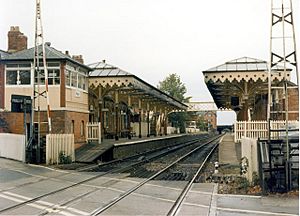
Hale railway station is right in the middle of Hale. It's on the Mid-Cheshire Line, which connects Chester and Manchester.
Famous Buildings and Fun Places in Hale
Royd House is a very special building on Hale Road. It was designed by a famous architect named Edgar Wood as his own home. It's considered one of the most advanced examples of home architecture from the early 1900s. Royd House is a very important historic building.
Hale Library is located on Leigh Road. In the center of Hale village, there's a bowling green where people can play a game called crown green bowling. Another bowling green is next to the Bull's Head pub in Hale Barns.
Hale also has many parks. One of them is Stamford Park, named after the Earl of Stamford, who used to live at Dunham Massey.
See also
 In Spanish: Hale (Gran Mánchester) para niños
 | Laphonza Butler |
 | Daisy Bates |
 | Elizabeth Piper Ensley |


