
Partington facts for kids
Quick facts for kids Partington |
|
|---|---|
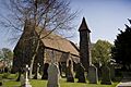
 St Mary's Church, a Grade II listed building |
|

Partington
|
|
| Population | 7,327 (2001 Census) |
| • Density | 5,348/sq mi (2,065/km2) |
| OS grid reference | SJ715915 |
| Civil parish |
|
| Metropolitan borough | |
| Metropolitan county | |
| Region | |
| Country | England |
| Sovereign state | United Kingdom |
| Post town | MANCHESTER |
| Postcode district | M31 |
| Dialling code | 0161 |
| Police | Greater Manchester |
| Fire | Greater Manchester |
| Ambulance | North West |
| EU Parliament | North West England |
| UK Parliament |
|
Partington is a town and civil parish in Greater Manchester, England. It is about 10 miles (16 km) southwest of Manchester city centre. The town is located on the southern bank of the Manchester Ship Canal. Across the canal is the town of Cadishead. In 2001, Partington had a population of 7,327 people.
The Manchester Ship Canal was finished in 1894. This made Partington an important port for exporting coal. Other industries also came to the town. Until 2007, a large chemical factory operated nearby. There is also a gas storage facility in Partington. This used to be a gasworks and employed many people.
After World War II, many people from crowded areas of Manchester moved to Partington. This area became known as an "overspill estate." A railway line opened in Partington in 1873 but closed in 1964.
Contents
- What is the history of Partington?
- How is Partington governed?
- Where is Partington located?
- What is the population of Partington?
- What is the economy like in Partington?
- What about education in Partington?
- How do people get around in Partington?
- What media is available in Partington?
- What facilities does Partington have?
- Images for kids
- See also
What is the history of Partington?
Partington was first mentioned in records in 1260. Its name comes from Old English words. It might mean "farmstead of Pearta's people" or "farmstead on divided land." The village had farms spread out, not a central area. It was surrounded by wetlands, which limited farming land. In 1664, about 99 people lived in Partington.

In 1755, a paper mill opened in Partington. This was the first factory in what is now Trafford. Erlam Farmhouse was built in the late 1700s. It is now a listed building, meaning it is protected for its history. The old stocks on the village green are also protected. Their stone parts are from the 1700s.
The Manchester Ship Canal changed Partington a lot when it opened in 1894. Partington became a major port for shipping coal. The canal was made wider there to build a special area for coal. This area had machines to load coal onto ships. Partington was close to the Lancashire Coalfields. This made it easier to send coal from Yorkshire to the sea. From 1898 to 1911, coal made up more than half of all exports on the canal.
The coal trade also led to Partington becoming a big railway hub. Many other businesses came to the town. This included the Partington Steel & Iron Company. They built a steelworks because coal was easily available. This factory later became part of the Lancashire Steel Corporation. It was very important to the nearby town of Irlam until it closed in 1976. After World War II, Partington grew as a place for people to move to from crowded cities.
How is Partington governed?
Partington became a civil parish in 1894. It has its own town council made up of local people. In 1974, Partington became part of the Metropolitan Borough of Trafford. Before that, it was in a different district.
Partington is also part of the Stretford and Urmston area for national elections. Since 1997, the Member of Parliament (MP) for this area has been from the Labour Party. Currently, Andrew Western is the MP.
Where is Partington located?
Partington is located at 53.42 degrees North and -2.43 degrees West. It is west of Sale and northeast of Warburton. The town is on Trafford's northern border with the City of Salford. It is about 9 miles (14 km) southwest of Manchester city centre.
A small stream called Sinderland Brook runs through the area. The town is generally flat and about 20 meters (66 feet) above sea level. Partington has a mild climate, similar to the rest of Greater Manchester. The average temperatures are a bit higher than the national average. The amount of rain is also higher, and there are fewer hours of sunshine.
What is the population of Partington?
In 2001, Partington had a population of 7,723 people. There were slightly more females than males. About 34.7% of people over 16 had never been married. Many households were single-person or married couples.
About 38.9% of people aged 16–74 did not have any school qualifications. This was higher than the average for Trafford and England. Partington has been described as one of the areas with more challenges in Greater Manchester.
Most residents in Partington reported being Christian in 2001. A smaller number followed other religions like Islam, Hinduism, or Judaism. About 14.7% said they had no religion.
What is the economy like in Partington?
The main shopping area in Partington is on Central Road. There is also a traditional market on Smithy Lane.
A Spanish company called SAICA bought land near the Manchester Ship Canal in 2009. They built a factory there to recycle paper into packaging. This factory is very modern. It uses water from the ship canal. Its power plant also creates extra electricity that goes to the national power grid. The factory cost £300 million and started making products in 2012.
In 2001, many people in Partington worked in retail and wholesale. Other common jobs were in manufacturing, business services, and health care. Compared to national numbers, Partington had more people working in transport and communication. It had fewer people working in public administration.
A higher number of people in Partington were permanently sick or disabled compared to the average for Trafford and England.
What about education in Partington?
Trafford uses a special system for schools. Students take an 11-plus exam to get into certain schools. Partington has three primary schools and one secondary school.
The oldest school still open is Partington Central Academy. It opened in 1958. There is also Forest Gate, another primary school. Our Lady of Lourdes Primary School is a Roman Catholic school. Broadoak School is the secondary school for students aged 11 to 16. Partington Central Academy, Forest Gate, and Broadoak School are all part of The Dean Trust.
How do people get around in Partington?

The main road in Partington is the A6144. This road connects to Lymm and Sale. The Manchester Ship Canal is also used for some industrial shipping. The closest road bridge over the canal is Warburton Bridge. This is one of the few old toll bridges left in the UK.
It has been noted that Partington is a bit isolated. This is because of the Manchester Ship Canal and the nearby chemical factories. Not many people in Partington own cars. A bus service, the 255, runs every 30 minutes during the day to Manchester Piccadilly.
Partington used to have a train station. It opened in 1873 and closed in 1964. The government gave money to help improve public transport in the town.
What media is available in Partington?
Local news and TV shows come from BBC North West and ITV Granada. TV signals are received from the Winter Hill TV tower.
Local radio stations include BBC Radio Manchester, Heart North West, and Capital Manchester. There are also other stations like Wythenshawe FM, which is a community radio station.
The local newspaper that serves the town is the Manchester Evening News.
What facilities does Partington have?


Partington and Carrington Youth Partnership (PCYP) started in 2003. It helps young people aged 11 to 25. They offer things like a 5-a-side football league and a skate park called Screamin' Wheels. In 2009, plans were made for a new £5 million youth centre. Students from Broadoak Secondary School helped design it. The centre will have places for dance, film-making, and art workshops. The headmaster of the school said it would help bring new life to the town.
A £2 million sports complex opened next to Broadoak Secondary School in 2008. It has a swimming pool, a sports hall, and outdoor sports fields.
Partington has several churches. There is an Anglican church called St Mary's. There is also a Roman Catholic church named Our Lady of Lourdes. A Methodist chapel and a Baptist church are also in the town. St Mary's Church is a protected historic building. Our Lady of Lourdes' RC Church started in 1957.
Images for kids
-
St Mary's Church, a Grade II listed building
See also
 In Spanish: Partington para niños
