Warburton, Greater Manchester facts for kids
Quick facts for kids Warburton |
|
|---|---|
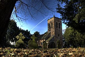
 St Werburgh's Church |
|
| Population | 286 (2001 census) |
| OS grid reference | SJ697896 |
| Metropolitan borough | |
| Metropolitan county | |
| Region | |
| Country | England |
| Sovereign state | United Kingdom |
| Post town | LYMM |
| Postcode district | WA13 |
| Dialling code | 01925 |
| Police | Greater Manchester |
| Fire | Greater Manchester |
| Ambulance | North West |
| EU Parliament | North West England |
| UK Parliament |
|
Warburton is a small village in Greater Manchester, England. It's located on the south side of the River Mersey. Even though it's part of the Metropolitan Borough of Trafford, Warburton still feels very much like a countryside village. The closest big town is Altrincham. In 2001, only 286 people lived here.
Warburton has been a settled place for a very long time, since at least the 11th century. There are 17 special old buildings in the village that are "listed," meaning they are protected because of their history. One of the most famous is the Church of St Werburgh, which is made of wood and is over 700 years old! Another church, also called St Werburgh's, was built later in 1883 by a famous architect named John Douglas. In 2006, the TV show Time Team visited Warburton to look for an old Roman fort, but they didn't find one.
Contents
A Look Back: Warburton's History
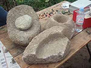
People have lived and worked in the Warburton area since the Bronze Age, which was thousands of years ago! We know this because archaeologists have found old tools made of flint, special grinding stones called quernstones, and even a snake bracelet from Roman times. These finds tell us that people have been farming here since at least the Roman period.
The name "Warburton" comes from an old name, Warburgtune, which was written in the Domesday Book. This book was a huge survey of England made in 1086 by William the Conqueror. The ending "–ton" means "settlement" or "farm" in Old English, suggesting the village was here even before the Normans arrived in 1066. Some people thought Warburton might have been an old Anglo-Saxon fort built by Queen Aethelflaed in 915 to fight the Vikings, but it seems that fort was probably somewhere else.
The Domesday Book is the first time Warburton is officially mentioned. It talks about two different areas, or "manors," in Warburton, which later joined together. Before the Normans, a powerful Anglo-Saxon lord named Aelfward controlled the land. Even though the Domesday Book doesn't mention a church, it's possible that the church dedicated to Saint Werburgh was built even before the Norman Conquest. The first official record of a church in Warburton is from 1187. It was a "chapel of ease," meaning it was a smaller church for people who lived far from the main parish church in Lymm. Warburton became its own separate parish in the 13th century. There was also a medieval priory (a small monastery) near the church, but it closed down in 1270.
For a long time, Warburton was mostly a farming village. A part of the area was even used as a deer park for hunting. Unlike many other places in England, Warburton didn't change much during the Industrial Revolution. This is why its population stayed quite small, even dropping a little between 1801 and 1901, while other towns nearby grew very quickly.
How Warburton is Managed
Warburton has its own local government called a parish council, which was set up in 1894. Since 1974, Warburton has been part of the Metropolitan Borough of Trafford. Before that, it was in a different area called Bucklow Rural District.
The village is part of the Bowdon area for local elections. Currently, the local councillors for Bowdon are all from the Conservative Party. For national elections, Warburton is part of the Altrincham and Sale West area. Since 1997, the Member of Parliament (MP) for this area, who represents the people in the House of Commons, has been Sir Graham Brady, also from the Conservative Party.
Warburton's Location and Landscape
Warburton is located next to the village of Lymm, which is in the borough of Warrington. The River Bollin forms the border between Warburton and Lymm. The Bollin river actually joins the River Mersey right here in Warburton! However, the Mersey riverbed in Warburton is now dry because the water was moved into the Manchester Ship Canal further upstream.
To the east of Warburton, you'll find places like Dunham Town, Dunham Massey, Bowdon, and Altrincham. To the south is Little Bollington, and to the north are Partington and Urmston. The ground in Warburton is mostly made of a type of rock called "lower keuper marl," and there's also a ridge of sand and gravel that runs towards Dunham.
Getting Around Warburton
The main roads that go through Warburton are the A6144 and the B5159. If you want to use public transport, there's a local bus service, number 5, which connects Warburton to Warrington and Altrincham.
Who Lives in Warburton?
In the 2001 UK census, Warburton had a population of 286 people. For every 100 females, there were about 121 males. The average number of people living in each home was 2.44.
When it came to education, about 43.2% of adults aged 16–74 in Warburton had no school qualifications or only one GCSE. This was similar to the average for all of Trafford (40.8%) and England (45.5%). The census also showed that 1.40% of people were unemployed, and 33.49% were "economically inactive," meaning they weren't working or looking for work (like retired people or students). About 16.43% of the population was under 16 years old, and 6.64% were 75 or older. The average age in Warburton was 43.03 years. Most residents, 69.34%, said their health was "good."
How Warburton's Population Has Changed
| Population growth in Warburton since 1801 | ||||||||||||||||||
|---|---|---|---|---|---|---|---|---|---|---|---|---|---|---|---|---|---|---|
| Year | 1801 | 1811 | 1821 | 1831 | 1841 | 1851 | 1861 | 1871 | 1881 | 1891 | 1901 | 1911 | 1921 | 1931 | 1951 | 1961 | 1971 | 2001 |
| Population | 466 | 470 | 509 | 510 | 509 | 489 | 484 | 452 | 426 | 416 | 403 | 403 | 379 | 354 | 376 | 328 | 289 | 286 |
| Source: | ||||||||||||||||||
Important Buildings and Places
Warburton's Churches
Warburton has two important churches, both named after St Werburgh. The older one (at grid reference SJ696895) is a timber-framed church. It's a "Grade I Listed Building," which means it's one of the most important historic buildings in the country. It's also one of the oldest timber-framed churches still standing in England and Wales. This church is at least 700 years old and might even be built on the site of an even older Saxon chapel. It's not used for regular church services anymore, but visitors can still see it. Inside, you'll find an old font from the early 1600s, a pulpit from the Jacobean period, and an altar from 1645. Nearby, you can see the remains of the old village cross and some stocks (a device used to punish people in the past).
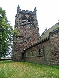
The newer church in Warburton, also dedicated to St Werburgh, was built in 1883 by the architect John Douglas. This church is a "Grade II Listed Building." It's made of red sandstone and has a clay tile roof.
Other Grade II Listed Buildings
Besides the two churches, there are 15 other "Grade II Listed Buildings" in Warburton. These include the parish rooms and the caretaker's house, which were also designed by John Douglas in 1889. Douglas also designed the post office (built in 1893) and Warburton School (built in 1871–72). The old school building is now a home, but you can still see its special "cruck" beams that support the roof.
Many old farm buildings in Warburton are also listed. For example, the farmhouse on Moss Lane has an 18th-century barn with even older "cruck" beams from the 17th century or earlier. Another timber-framed farm building on Park Road dates back to the 17th century. The farmhouse on Warburton Lane, built in the late 1700s, is made of "Flemish bond" brick and has a slate roof. The barn on Paddock Lane is from the 17th century. Also on Paddock Lane are two farmhouses: one built in 1717 with a large "inglenook" fireplace, and Wigsey Farmhouse, which started in the 17th century with later additions. An old timber-framed building from the 1500s or early 1600s on Warburton Lane has old paintings (frescoes) from that time, showing a woman (maybe St Werburgh) with geese and a rose.
You can also find the base of an old stone cross and wooden stocks on Townfield Lane, probably from the 17th century. One unique listed structure is a 25-meter long wall made of flat stones, likely built in the 1700s or 1800s. In the grounds of the old St Werburgh's Church, there's a "lychgate" (a covered gateway to a churchyard) from the late 1800s and a sundial from 1765.
Warburton Toll Bridge
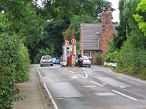
The Warburton Toll Bridge and its road are privately owned. This means you have to pay a small fee, or "toll," to cross it. The main bridge is a "cantilever bridge" that goes over the Manchester Ship Canal. It connects the B5159 road with the A57 and A6144. This bridge was built because of a law passed in 1863 called the Rixton and Warburton Bridge Act.
Originally, there was a stone bridge over the River Mersey. But when the Manchester Ship Canal was built, the river was moved, and a new bridge had to be built over the canal. The company that owns the bridge is responsible for all its costs and upkeep. It's one of the few old toll bridges left in the United Kingdom that existed before motorways were common, and it's the only one in Greater Manchester.
Some people mistakenly think the toll is for crossing the old, now-unused Mersey bridge. However, the law clearly states that the toll is for "passing over, along or upon the Bridge and Roads, or any of them." This includes the new bridge over the Ship Canal. The amount of the toll can be changed under a law from 1954.
Time Team Visits Warburton
Since 1998, archaeologists have found many interesting things in Warburton, from very old flints and Bronze Age axe heads to Roman coins, brooches, and a snake bracelet. Because of these finds, a local historian invited the TV show Time Team to dig in Warburton in September 2006. They were looking for a small Roman fort that earlier digs suggested might be there.
Even though they didn't find a Roman fort, they did find signs of a "Romano-British" farm. This means there was a farm in Warburton during the time the Romans were in Britain. The Roman items found earlier were probably just rubbish mixed with manure that farmers spread on their fields.
 | John T. Biggers |
 | Thomas Blackshear |
 | Mark Bradford |
 | Beverly Buchanan |


