
Flixton, Greater Manchester facts for kids
Quick facts for kids Flixton |
|
|---|---|
 Flixton House |
|

Flixton
|
|
| Population | 10,786 (2011) |
| OS grid reference | SJ755945 |
| Metropolitan borough | |
| Metropolitan county | |
| Region | |
| Country | England |
| Sovereign state | United Kingdom |
| Post town | MANCHESTER |
| Postcode district | M41 |
| Dialling code | 0161 |
| Police | Greater Manchester |
| Fire | Greater Manchester |
| Ambulance | North West |
| EU Parliament | North West England |
| UK Parliament |
|
Flixton is a lively area and an important local voting district in Trafford, Greater Manchester, England. In 2011, about 10,786 people lived here. Flixton is located about six miles (9.7 km) southwest of Manchester city centre. It is part of the historic county of Lancashire.
People might have lived in Flixton a very long time ago. Tools from the Neolithic (New Stone Age) and Bronze Age have been found here. In the Middle Ages, Flixton was a small area with farms and a manor house. It was first mentioned in records around the 1100s.
Towards the end of the 1600s, more people started moving to Flixton. This growth continued through the 1800s. Flixton was a quiet, rural place. It didn't have as many factories as other parts of Manchester. However, when the railway arrived in 1873, Flixton began to change. It became a popular place for middle-class families to live.
Today, Flixton is represented in the UK Parliament by Andrew Western. He is a MP from the Labour Party.
Contents
What's in a Name? (Etymology)
The name Flixton has been spelled in many ways over time. Some old spellings include fflixton, Fluxton, and Flyxton. Flixton is not mentioned in the very old Domesday Survey book. It first appears in historical records around 1176 or 1177.
The name might come from a Scandinavian word. The Anglo-Saxon word ton means a farmstead or settlement. So, Flixton could mean "Flik's farm" or "Flik's settlement." It's possible the name comes from a person's name from the 900s or 1000s.
Flixton's Past (History)
Ancient Times
People may have lived in the Flixton area during the Neolithic and Bronze Ages. Stone axes have been found near the River Mersey in Flixton. Similar tools were also found near the River Irwell in Old Trafford. Arrowheads from these ancient times have been discovered nearby in Altrincham and Warburton.

During the Middle Ages, Flixton was one of several parishes in the Hundred of Salford. A parish is like a local area. The manor of Flixton was first mentioned around 1189. A manor was a large estate with a lord and workers. The boundaries of the Flixton manor are not fully clear today.
St Michael's Church was also first recorded around this time. The church building itself might be even older. In medieval Flixton, there wasn't a main village centre. Instead, there were separate farms and a medieval manor house.
One important old place was Shaw Hall. Its name first appeared in 1508. It was a large estate and was called a manor in 1594. Shaw Hall was home to several important families. During the English Civil War, it was defended against attacks. The Egerton family lived there until 1757. The hall was later demolished in the 1900s.
An old book called the Testa de Nevil mentions Flixton. It says that Albert Gredle gave land in Flixton to Henry, son of Siward. The Grelley family, who were important lords of Manchester, controlled the manor of Flixton for a while. Later, in 1190, Robert of Lathom gave the parish of Flixton to a new monastery called Burscough Priory.
Over time, the Hulton family gained control of the manor. In 1330, they rented out parts of it to the Valentine family and two branches of the Radcliffe family. The Valentine family name appears in Flixton's old church records. These records, starting in 1570, show baptisms, marriages, and burials. They were written on vellum (animal skin) and mostly in Latin.
The Industrial Revolution and Change

Flixton's population stayed about the same until the late 1600s. Then, like other nearby areas, it started to grow. At that time, Flixton was a small village. It had a few buildings around the church and its parsonage. In 1664, records show 70 households in Flixton. Most people probably worked in farming.
There is also evidence that some areas were used for making textiles. "Yarn croft" in Flixton suggests that flax was grown and used to make cloth. Many old documents from nearby areas mention textiles, hemp, and flax.
Flixton played a role in early efforts to protect public footpaths. In the 1820s, a local landowner named Ralph Wright tried to close a path across his land. Local people and a newspaper called the Manchester Gazette fought against this. This led to the creation of the "Manchester Association for the Preservation of Ancient Public Footpaths" in 1826. This group later became the "Peak and Northern Footpath Society," which still exists today.
During the Industrial Revolution, many towns grew very quickly. However, Flixton was different. Its population only grew by 22% between 1801 and 1851. This was much slower than places like Altrincham or Stretford. Many villagers moved to areas with more factories. Also, farming was difficult in the 1830s and 1840s.
Making textiles at home, which was common in Flixton, slowly ended. Even after Flixton Cotton Mills were built in 1851, home textile production stopped within ten years. Flixton did not become a big industrial town like Ashton-under-Lyne. The reasons why Flixton remained more focused on farming are not clear.
Flixton was quite isolated. The rivers Irwell and Mersey made it hard to travel to other towns. Old bridges were too narrow for carts. An omnibus service carried people to Stretford, where the nearest railway station was. However, everything changed when Flixton got its own railway connection on September 2, 1873. This line connected Manchester to Liverpool.
A new bridge across the Mersey was built around 1906–1907. This replaced an older structure. Slowly, Flixton became a popular railway suburb for people working in Manchester.
How Flixton is Governed
Local Government History
In 1841, Flixton became part of the Chorlton Poor Law Union. This was a system for helping the poor. Later, in 1849, it moved to the Barton upon Irwell Poor Law Union.
In 1894, new laws created urban and rural district councils. Flixton became part of the Barton upon Irwell Rural District. Some land was exchanged with nearby areas like Irlam and Carrington. In 1933, Flixton became part of the Urmston Urban District.
Where is Flixton? (Geography)

Flixton is located at about 53.44 degrees North and 2.38 degrees West. It is about 170 miles (274 km) northwest of central London. Flixton is situated between Urmston to the east and Irlam to the west. It is part of the Greater Manchester Urban Area. Manchester city centre is about 6.4 miles (10.3 km) to the north-northeast.
The southern border of Flixton is formed by the River Mersey. The Manchester Ship Canal, which follows the old path of the River Irwell, became the western boundary in 1896. Today, the western boundary is a bit further east. Most of Flixton's population lives in the northern part. The southern part is mostly open land.
People of Flixton (Demography)
According to the 2001 Census, Flixton had a population of 9,473 people. Most residents (9,164) were white. The rest were from mixed race, Asian, Black, or Chinese backgrounds.
Many people in Flixton are married (3,543 first-time married). About 3,789 people are single. Most residents (7,771) identify as Christian. About 952 people said they had no religion. Smaller numbers of people identified as Muslims, Hindus, Buddhists, or Jewish.
Most homes in Flixton (83.1%) are owned by the people who live in them. Most houses are semi-detached. Others are detached, terraced, or flats. In 2010, the average household income was £39,231. In 2001, about 46.1% of people aged 16–74 worked full-time. About 16.5% were retired.
Arts and Entertainment (Culture)

The Flixton Band was started in 1877. They even played at the official opening of the Manchester Ship Canal in 1894, which Queen Victoria attended! The band stopped playing in 1933 but started again in 1967. Since then, they have performed on TV and radio.
A local artist named Frances Lennon moved to Flixton in the late 1970s. She became a full-time painter after her husband passed away. She wrote several books, including A Trafford Childhood (1986). Frances Lennon was known as "the people's artist." She was the official artist for the 2002 Commonwealth Games. In 2003, she received an MBE award from Prince Charles for her contributions to art and charity.
Places of Worship (Religion)
Flixton is part of the Church of England Diocese of Manchester. It is also part of the Roman Catholic Diocese of Salford. For many years, church life has focused on the 12th-century St Michaels Church. This church is a Grade II* listed building. Another Church of England church, St John's Church, is on Irlam Road. Flixton's Catholic community attends St Monica's Church on Woodsend Road South. This church was built between 1968 and 1969.
Important Places (Landmarks)
Flixton House is a beautiful building from the late 1700s. It is a Grade II listed building. It sits in Flixton Park and Gardens. This house was central to one of the first battles over footpaths in England. In 1824, the owner, Ralph Wright, tried to close paths on his land. Local people fought back, and after many legal arguments, the footpaths were reopened. This event was very important for protecting public footpaths in England.
Abbotsfield Park hosted a Beatles concert in 1963. This was before they became super famous! The Urmston and District Model Engineering Society has a miniature railway in the park. They used to have a yearly May Day Steam rally there.
Old Stocks, which were used to punish people, were once in Flixton village. They were removed in 1823. A tree planted in 1887 to celebrate Queen Victoria's Golden Jubilee, known as 'The Jubilee Tree', now stands in the same area.
To the southwest is Green Hill. From here, you can see the disused Flixton Sewage Works. This area is made from ash and is a good habitat for plants like gorse. It's also home to moles. The former sewage works is an important place for wild birds in winter, such as marsh harriers. Nearby, Duttons Pond is a private pond where people can go fishing. West of Dutton's Pond is Jack Lane nature reserve. This small marshland is a home for wetland birds.
Getting Around (Transport)

Public transport in Flixton is managed by Transport for Greater Manchester.
Trains
Flixton has two local railway stations: Flixton and Chassen Road. Both are managed by Northern.
Buses
Bus services in Flixton connect to places like Davyhulme, Urmston, Stretford, Partington, Hulme, and Manchester.
Learning in Flixton (Education)
Flixton has several schools for primary and secondary students. The first school was founded in 1643 by Peter Egerton. It was built near the parish church. Another school opened in 1662 near the Roebuck pub. A school built in 1861 near the parish church was later demolished.
Flixton Girls' School is a secondary school for girls aged 11–16. It is an academy school that specializes in sports. An inspection report in 2011 called it a good school. It was praised for how it helps the community. Another local school, Wellacre Academy, was described as "an outstanding and happy school."
| School | Description | Ofsted | Website |
|---|---|---|---|
| Acre Hall Primary | Primary school | 133642 | |
| Flixton Primary School | Primary school | 106318 | website |
| St Michael's C.E. Primary School | Primary school | 106350 | website |
| St Monica's R.C. Primary School | Primary school | 106356 | website |
| Flixton Girls' School | Secondary school | 106364 | website |
| Wellacre Academy | Secondary school | 106366 | website |
| Delamere Special School | Special school | 106394 |
Sports and Fun (Sport)

In the past, Flixton was a place where activities like bull and bear baiting took place. These were cruel practices that ended in 1816. Badger baiting also happened at some inns. There are also stories that hunting, cockfighting, and horse racing took place in the fields around the church.
Trafford Football Club was formed in 1990. They play in the Northern Premier League. Flixton also has a privately owned golf course called Flixton Golf Club. The William Wroe golf course was opened in 1973. It was named after Councillor William Wroe. This course was expanded over the years to eighteen holes. However, it was closed in March 2017 due to council budget cuts. In 2023, the former golf course land was given special protection as a "Fields in Trust" site.
Images for kids
-

Flixton House
-
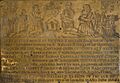
The Radclyff Brass, now in St Michael's Church. Richard Radclyff lived in nearby Urmston.
-
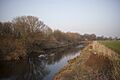
The River Mersey forms Flixton's southern border.
-

Dutton's Pond
-

St Michaels Church in Flixton Village.
-
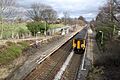
Chassen Road railway station.
-
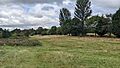
The former William Wroe Golf Course in 2022.
