
Whalley Range, Manchester facts for kids
Quick facts for kids Whalley Range |
|
|---|---|
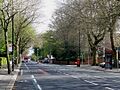
 Upper Chorlton Road in Whalley Range |
|

Whalley Range
|
|
| Population | 15,430 (2011) |
| OS grid reference | SJ831948 |
| Metropolitan borough | |
| Metropolitan county | |
| Region | |
| Country | England |
| Sovereign state | United Kingdom |
| Post town | MANCHESTER |
| Postcode district | M16 |
| Dialling code | 0161 |
| Police | Greater Manchester |
| Fire | Greater Manchester |
| Ambulance | North West |
| EU Parliament | North West England |
| UK Parliament |
|
| Councillors |
|
Whalley Range is an area in Manchester, England. It's located about 2 miles (3.2 km) south-west of the city centre. In 2011, about 15,430 people lived there. This area used to be part of Lancashire. It was one of the first suburbs built in Manchester by a local businessman named Samuel Brooks.
Contents
History of Whalley Range
Whalley Range was one of the first planned suburbs in Manchester. It was created by a banker and businessman, Samuel Brooks. He wanted to build a nice area for "gentlemen and their families" to live.
In 1834, Samuel Brooks bought a lot of land. He drained the land, which was covered in peat (a type of soil made from decayed plants). He started building large houses, called villas, for rich businessmen like himself. Brooks was born near Whalley, and he named his own home Whalley House. This might be how the area got its name.
A special gate, called a toll gate, used to guard this area. People had to pay a fee to enter. This spot, where Chorlton Road and Withington Road meet, is still known as Brooks's Bar. The toll gate was removed in 1896.
For a long time, the people living in Whalley Range didn't want it to become a separate town or city. They even had their own private police force to collect tolls and protect their homes! This private police force lasted until World War I.
There was a myth that you couldn't buy alcohol in Whalley Range. But this wasn't true! The area had private clubs, a public hall, and a cinema. There were also pubs like the 'Caught on the Hop' and the 'Whalley Hotel'.
The area was originally planned to be much bigger. However, it was hard to drain the land, and later, a railway was built, which changed the plans. Many roads in Whalley Range are actually built over hidden streams.
Since the late 1940s, Whalley Range has been home to a large Polish community. On June 24, 2012, the Olympic Torch passed through Upper Chorlton Road as part of its journey across the country.
Travel and Transport
For a long time, public transport wasn't allowed in Whalley Range. No railway lines were built through the area. The closest train station was at the end of Alexandra Road South. It was built to serve the Alexandra Park Aerodrome, a small airport nearby. This airport even had flights to Croydon Airport in London! The airport closed in 1924, and the train station closed in 1964.
Horse-drawn trams used to stop at the edge of Whalley Range. Later, in the 1920s, trams and buses served the area fully. There were also taxi stands outside the shops and hotels.
Manley Hall: A Grand House
Manley Hall was a very grand house built in the 1860s by a rich businessman named Samuel Mendel. It cost a huge amount of money to build – £120,000! The hall had beautiful gardens and a large art collection.
However, Samuel Mendel faced financial problems and had to sell the hall. No one could afford to buy such a huge house, so it fell apart. Before it was torn down around 1905, it was used as a pleasure garden. Even "Buffalo Bill's Wild West Show" visited there!
Votes for Women!
Whalley Range had something special for Victorian times: some women could vote! In those days, if you owned property and paid certain taxes, you could vote on local matters, no matter if you were a man or a woman. This meant that wealthy widows and single women (spinsters) could vote. This was unusual for the time, as married women usually couldn't vote because their property was controlled by their husbands. This right to vote for women in local elections ended when the area became part of the city.
Local Government
_2018.png)
Whalley Range is part of the Manchester City Council. The area is represented by three councillors from the Labour party: Angeliki Stogia, Muqaddasah Bano, and Aftab Razaq.
The area's boundaries for voting have changed over time. Since 2017, the area has been represented in the UK Parliament by Afzal Khan.
Geography and Landscape
Whalley Range is known for its large Victorian houses, many of which have been divided into flats. There are also newer apartment buildings and some early 20th-century homes. Many roads are lined with trees, making the area look green and pleasant.
There aren't many big shops in Whalley Range. Most of the shops are found on Withington Road and Upper Chorlton Road.
An interesting fact about Upper Chorlton Road is that for most of its length, the two sides of the road are in different areas! One side is in the City of Manchester, and the other is in the Borough of Trafford. This means things like streetlights and old tram systems used to look different on each side.
The area also has some private roads, like Green Walk. These roads were not owned by the local council. Many old "lanes" were renamed "roads" to sound more important.
People of Whalley Range
According to a census in 2001, the people living in Whalley Range came from many different backgrounds:
- White British – 48.86%
- White Other – 4.43%
- White Irish – 3.39%
- Mixed Race – 4.23%
- British Asian – 28.48%
- Black British – 8.24%
- Chinese or other – 2.37%
Places of Worship

Religion was very important in Victorian times, and Whalley Range has many churches and other religious buildings. Even though Samuel Brooks was a member of the Church of England, he allowed other Christian groups, like Roman Catholics and Methodists, to build their churches in the area.
Some of the churches include:
- St Margaret's Church (Anglican)
- St Edmund's Church (Anglican) – the old building is now apartments, and the church meets in a new building next door.
- Manchester Chinese Church
- Whalley Range Methodist Church
- Manley Park Methodist Church
- English Martyrs Roman Catholic Church – known for its tall spire.
- New Testament Church of God
- Spiritualist churches
Other Places of Worship

Whalley Range is also home to other faiths:
- Minhaj-ul-Qur'an Central Mosque and other smaller mosques.
- British Muslim Heritage Centre.
- A Hindu temple in a former chapel.
- A Gurdwara (Sikh place of worship) on Upper Chorlton Road, which opened in 2011.
- The Hare Krishna movement has a centre on Mayfield Road.
Sports in Whalley Range
Whalley Range has a long history of sports:
- Whalley Range AFC (football club) was started in 1900 and is still active today. It has two pitches and a clubhouse.
- Whalley Range Lawn Tennis & Cricket Club was established way back in 1845!
Education in Whalley Range
Whalley Range has several important educational buildings and schools.
The Lancashire Independent College on College Road was built between 1840 and 1843. It was created to train ministers for the church. It's a well-known building in the area and has always been used for education. During World War II, it even housed refugee academics from Czechoslovakia. Today, it is the British Muslim Heritage Centre (BMHC) and has been beautifully renovated.
Secondary Schools

- St Bede's College (on Alexandra Road South) is a Roman Catholic independent school. It was founded in 1876 in a building that was first meant to be an aquarium! The building is made of red brick and terracotta and has fancy decorations.
- William Hulme's Grammar School (in Springbridge Road) was established in 1887. It used to be a private school but became a state-funded academy in 2007. It specializes in languages.
- Hartley College (on Alexandra Road South) was built in 1879 as a Methodist college. It is now a Muslim school called Kassim Darwish Grammar School for Boys.
- Whalley Range High School is a large secondary school for girls on Wilbraham Road. It moved to this location in the 1930s. Many students at the school come from different ethnic backgrounds and speak languages like Urdu, Somali, and Arabic. The school focuses on business, enterprise, and sports. A famous former student is Estelle Morris, who became a government minister.
Primary Schools
- Our Lady's R.C. Primary School on Whalley Road used to be partly housed in a building that was once the German consulate!
- Manley Park County Primary School was built on land that was originally planned for more houses, but the authorities decided a school and recreation ground were needed for the growing number of children.
- St Margaret's CE Primary School on Withington Road is on the site where Whalley Range High School used to be before World War II.
Hospitals
The Spire Manchester Hospital used to be located on Russell Road. It was a private hospital that moved to a new location in 2016. The site where it stood was once home to the Nello James Centre and, even earlier, a Red Cross Hospital during the First World War.
Famous Connections
Whalley Range has been home to or mentioned by several famous people:
- The poet Jane Crewdson lived here.
- The writer Dodie Smith, who wrote 101 Dalmatians, spent part of her childhood here.
- The band The Smiths mentioned Whalley Range in their song "Miserable Lie".
- Steve Hopkins, a record producer, lives and has an art studio here.
- Actor and journalist Nigel Pivaro was baptized at English Martyrs RC Church.
- Comedian and writer Les Dawson passed away at the Spire Hospital in Whalley Range.
- John Prettyjohns, the first Royal Marine to receive the Victoria Cross, was a steward at the Whalley Range Bowling Club.
- The band James formed here in 1982.
- Comedian Jason Manford grew up in Whalley Range and went to St. Margaret's Primary School.
- Gillian Gilbert of the band New Order was born here.
Images for kids
-
Upper Chorlton Road in Whalley Range
-
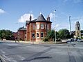
Whalley Hotel, Brooks's Bar

