
Abram, Greater Manchester facts for kids
Quick facts for kids Abram |
|
|---|---|
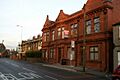
 Former Abram Council Offices |
|

Abram
|
|
| Population | 9,855 (2001 Census) |
| OS grid reference | SD609015 |
| • London | 173 mi (278 km) SE |
| Metropolitan borough |
|
| Metropolitan county | |
| Region | |
| Country | England |
| Sovereign state | United Kingdom |
| Post town | WIGAN |
| Postcode district | WN2 |
| Dialling code | 01942 |
| Police | Greater Manchester |
| Fire | Greater Manchester |
| Ambulance | North West |
| EU Parliament | North West England |
| UK Parliament |
|
Abram is a village in Greater Manchester, England. It's also an area that elects its own local representatives. The village is on flat land next to the Leeds and Liverpool Canal. It's about 2 miles (3.2 km) west of Leigh, 3 miles (4.8 km) southeast of Wigan, and 14.5 miles (23 km) west of Manchester. Abram is a place where many people live and travel to work in bigger towns nearby. About 9,855 people live here.
Long ago, Abram was part of Lancashire. It was a small area called a township and had its own small church area called a chapelry. In 1212, it was known as "Edburgham".
Abram grew a lot during the Industrial Revolution. This was a time when factories and industries became very important. Abram became a center for coal mining in the mid-1800s, with many collieries (coal mines) opening. In 1911, people described Abram as not very pretty because of all the smoke and mining activity. There were many coal mines, piles of coal waste, and railway lines. However, there was also a lot of farmland. A very sad event happened in 1908 called the Maypole Colliery Disaster, where 75 people died. This event deeply affected the village.
The coal mining industry in Abram started to close down in the mid-1900s. But the village kept growing because it's located between important towns like Leigh, Manchester, Warrington, and Wigan. South of the village is a special nature area called Abram Flashes. It's a 39.6 hectares (97.9 acres) area of shallow wetlands and is protected as a Site of Special Scientific Interest. Abram is also known for its traditional Morris dancing.
Contents
History of Abram Village

The name of the village has changed over time. In 1212, it was called Edburgham, and in 1246, Adburgham. By the 1500s, it was known as Abraham, and by the 1600s, it became Abram. Some people think the name Abram comes from the surname of the old Lords of the Manor (the main landowners) who were called Abraham.
The manor (the land and houses controlled by a lord) of Abram was probably part of a larger manor called Newton. King Henry II (who ruled from 1154 to 1189) gave it to a person named Warine, son of Godfrey. This family then took the name of the settlement, Abram, and stayed as the Lords of the Manor until the 1600s. They lost their wealth during the English Civil War because they supported the King. After the last male in the Abraham family died, the manor changed hands many times. Even in the early 1900s, someone still held the title of Lord of the Manor, but they didn't have any special rights over the land anymore.
On August 18, 1908, just after 5 PM, a terrible explosion happened at the No 1, Cannell Mine of the Maypole Coal Pit. A total of 75 men and boys died in this mining accident. Because the explosion happened deep underground, it took a long time, until November 1909, to find all the bodies. An investigation found that the explosion was caused by a mix of coal dust and gas, along with the use of explosives to break up coal. This disaster had a huge impact on Abram. It left 44 women as widows and more than 120 children without their fathers. Many of the families affected, especially Irish immigrants who had come to work in the coal mines, moved back to Ireland soon after.
How Abram is Governed

Since the early 1100s, Abram has been part of Lancashire. In the Middle Ages, it was a township within the larger church area of Wigan. It was also part of a bigger region called the hundred of West Derby, which was a way of dividing land for taxes and law.
After a law change in 1834, Abram became part of the Wigan Poor Law Union. This was a group of local areas that worked together to help people who were poor. Abram got its first local council, called a Local Board of Health, in 1880. This group was in charge of keeping the township clean and healthy. In 1894, this board became the Abram Urban District, which was a local government area within Lancashire. This council had 12 members and met at the Abram Council Offices, built in 1903.
In 1957, some small parts of Abram were exchanged with nearby areas. Then, in 1974, the Abram Urban District was ended. Since then, Abram has been part of the Metropolitan Borough of Wigan, which is a local government area in Greater Manchester. The Wigan Metropolitan Borough Council provides all the local services for Abram.
For national elections, Abram is part of the Makerfield constituency. The person who represents Abram in the UK Parliament is Josh Simons, who is a member of the Labour Party.
Abram's Location and Surroundings
 |
Wigan | Ince-in-Makerfield | Hindley | |
| Winstanley | Bickershaw | |||
| Ashton-in-Makerfield | Golborne | Lowton |
Abram is located at 53°30′29″N 2°35′17″W / 53.50806°N 2.58806°W. It's about 173 miles (278 km) northwest of central London. The land around Abram is mostly flat, with some small hills to the south. The larger towns of Wigan and Leigh are to the northwest and east. Abram is considered part of the Wigan Urban Area. Some nearby areas include Bamfurlong, Bickershaw, Bryn Gates, and Platt Bridge.
The land around Abram is generally flat and was used for coal mining and farming. Because of this, many coal mines were spread across the area. The ground beneath Abram has coal layers in the north and sandstone in the south. The soil is clay, which means the area can sometimes flood.
South of the village is Abram Flashes, a 39.6-hectare (97.9-acre) Site of Special Scientific Interest (SSSI). This special area is next to the Leigh Branch Canal. It's part of a larger wetland area called Wigan Flashes, which stretches for 10 kilometres (6.2 mi) between Wigan and Leigh. The "flashes" are shallow bodies of water that formed when the ground sank due to old mining activities, causing water to collect. Abram Flashes was made an SSSI in 1990 because it's home to many different plants and animals, with various habitats like open water, swamps, and wet grasslands.
People in Abram
| Abram compared | |||
|---|---|---|---|
| 2001 UK census | Abram | Wigan (borough) | England |
| Total population | 9,855 | 301,415 | 49,138,831 |
| White | 98.3% | 98.7% | 90.9% |
| Asian | 0.7% | 0.4% | 4.6% |
| Black | 0.2% | 0.2% | 2.3% |
In 2001, Abram had a population of 9,855 people. There were slightly more females than males. About 30.3% of people over 16 had never been married, and 43.2% were married. Out of 4,037 homes, 27.2% were single-person households, 40.0% were married couples, and 12.5% were single parents with children. Also, 42.2% of people aged 16–74 did not have any formal school qualifications.
The 2001 census also showed that most residents in Abram were Christian (84.7%). A small number were Muslim (0.9%), Buddhist (0.2%), or Sikh (0.1%). About 6.5% said they had no religion, and 7.5% did not say what their religion was.
| Population growth in Abram since 1901 | ||||||||||||
|---|---|---|---|---|---|---|---|---|---|---|---|---|
| Year | 1901 | 1911 | 1921 | 1931 | 1939 | 1951 | 1961 | 1971 | 1981 | 1991 | 2001 | |
| Population | 6,306 | 6,893 | 6,853 | 6,660 | 5,761 | 6,284 | 6,004 | 6,475 | 12,423 | 11,428 | 9,855 | |
| Urban District 1901–1971 • Urban Subdivision 1981–2001 | ||||||||||||
Important Buildings in Abram

The main church in Abram is St John's Church. It was built between 1935 and 1937 by famous architects Austin and Paley. There are two listed buildings in the village, which means they are protected because of their special history or architecture. Both are Grade II listed. One is Brookside farmhouse, built in the early 1700s, and the other is a house on Warrington Road from the mid-1700s.
Getting Around Abram
Public transport in Abram is managed by Transport for Greater Manchester. Main roads connect Abram to other places. The A573 road goes through the middle of the town, linking it to Wigan and Golborne. The M6 motorway is to the southwest, near Ashton in Makerfield. You can get to it from the A58 at junction 24 of the M6.

There used to be a train station called Bickershaw & Abram railway station. It opened in 1884 but closed in 1964.
Today, there are frequent buses that run through Abram. They can take you to many places in Greater Manchester, including Wigan, Leigh, and Manchester.
The Leeds and Liverpool Canal also passes by Abram to the southwest.
Culture and Community in Abram

Abram has a long history with traditional Morris dancing. The village is home to the Abram Morris Dancers. There's even a piece of land near Park Lane called the Morris Dancers' ground. People say that the Abram Morris Dancers own this land as long as they perform a Morris dance there once every 20 years. The "Abram Circle" is a special dance that started in Abram and is well-known among Morris dancers. The Abram Morris Dancers' logo is even on the signs that welcome you to the village.
Abram has one main primary school: St John's Church of England Primary School.
Famous People from Abram
- John Elisha Grimshaw was born in Abram. He received the Victoria Cross, which is the highest award for bravery in the British and Commonwealth forces.
- Jenny Meadows is a British athlete. She went to Abram C of E Primary School and still lives in Abram today. She is best known for running the 800-meter race and was the European Indoor Champion in 2011.
- Mick Burke was a well-known mountaineer and rescuer who lived in Abram. He sadly died on Mount Everest in 1975 while working as a cameraman for the BBC.
See Also
- List of schools in Wigan
Images for kids
-
Former Abram Council Offices
