Horwich facts for kids
Quick facts for kids Horwich |
|
|---|---|
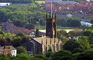 Horwich Parish Church |
|
| Population | 20,067 (2011 Census) |
| OS grid reference | SD639114 |
| • London | 177 mi (285 km) SE |
| Civil parish |
|
| Metropolitan borough |
|
| Metropolitan county | |
| Region | |
| Country | England |
| Sovereign state | United Kingdom |
| Post town | BOLTON |
| Postcode district | BL6 |
| Dialling code | 01204 |
| Police | Greater Manchester |
| Fire | Greater Manchester |
| Ambulance | North West |
| EU Parliament | North West England |
| UK Parliament |
|
| Website | www.horwich.gov.uk |
Horwich (pronounced HORR-itch) is a town and civil parish in Greater Manchester, England. It's located near the beautiful West Pennine Moors. In 2011, about 20,067 people lived there.
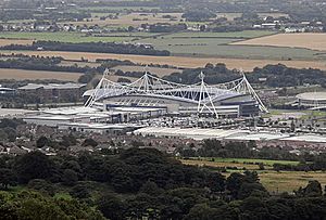
Horwich began in the Middle Ages as a place for hunting. During the Industrial Revolution, streams from the moors helped power factories, especially for bleaching and textiles. After 1884, a large railway workshop was built, making the town grow very quickly. Today, the old factories are closed. New developments, like Middlebrook, have brought new life to Horwich. Since 1997, the University of Bolton Stadium, home to Bolton Wanderers football club, has been a big part of Middlebrook.
Contents
History of Horwich
The name Horwich comes from old English words meaning "place at the grey wych-elm tree." It was first written as Horewic in 1221.
Early Horwich and the Forest
Long ago, Horwich Forest was home to wolves. Early Saxon kings used the forest for hunting. Horwich grew from a small settlement near the River Douglas. By the Middle Ages, it was a hunting area owned by powerful families. People who trespassed in the forest were punished by the local lord. The forest began to shrink after King Henry VIII took over church lands and sold them.
Life Before Factories
By the 1500s, Horwich became more of a farming area. Forests were cleared for farms. Many families also wove cotton at home. Industries like bleaching, dyeing, and paper making grew because of the many streams. This continued until the railway workshops arrived in the 1800s.
In 1598, a map called 'The Platt of Horwich' showed the land owned by Sir Thomas Barton. Horwich Moor, a large open area, was divided up between 1815 and 1818. Horse races were held there from 1837 to 1847.
The Industrial Revolution in Horwich
In the 1770s, brothers John and Joseph Ridgway started a bleach works in Horwich. Their factory was one of the first to use new chemical bleaching methods. They even installed a steam engine in 1798.
Horwich Vale Printworks, started in 1799, printed cloth using machines and hand-blocks. Stone was quarried from Winter Hill, and there were small coal mines. Cotton mills also opened in the mid-1800s.
The Ridgways helped build "Club Houses," a group of stone cottages for workers. Some of these homes had basements for hand loom weaving.
Horwich Becomes a Railway Town
In 1881, Horwich had about 3,761 people. But then, the railway works and new cotton mills arrived. This caused a huge change! By 1891, the population jumped to 12,850. Horwich truly became a "railway town."
This growth meant more homes, schools, and shops were needed. Many new streets of brick houses were built for the workers. These homes are still used today. The Horwich Public Hall, built in 1879, became the local government building and is still in use.
In 1937, the de Havilland Aircraft Company built a factory in Horwich. During World War II, this factory made parts for Spitfires. This made it a target for German bombers. In 1940, King George VI and Queen Elizabeth visited the town to recognize its war efforts. The factory later became part of British Aerospace and now makes missiles.
The Horwich Railway Works
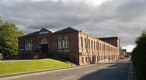
From 1884 to 1983, the railway works completely changed Horwich. This huge complex was built to construct and repair locomotives. The first workshop, Rivington House, opened in 1887. It was very long, with tall arched windows.
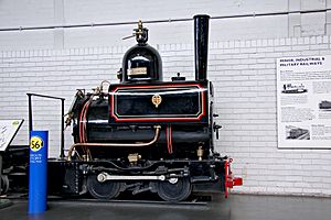
The first locomotive built in Horwich, Number 1008, left the works in 1887. You can still see it at the National Railway Museum.
During both the First and Second World War, the works helped with the war effort by making tanks and ammunition. Women were employed in the factories during the wars.
The railway company changed names over the years, eventually becoming British Railways in 1948. The works continued to build and repair locomotives. The last steam locomotive was built in 1957. After that, they made diesel trains and repaired wagons.
Sadly, on February 18, 1983, it was announced that the works would close. Despite protests, Horwich Works closed on December 23, 1983, after 97 years. This caused high unemployment in the town.
The land where the railway works stood was later given to Bolton Council. There were some health concerns related to old building materials used at the site. The area is now being redeveloped with new homes and businesses.
After the railway works closed, Horwich faced tough times. But the development of the Middlebrook Retail Park and the arrival of Bolton Wanderers F.C. helped the town recover. Horwich is now known for its homes and good transport links.
How Horwich is Governed
Horwich has been part of Lancashire since the 1100s. In 1894, it became the Horwich Urban District. In 1974, Horwich became part of the new Metropolitan Borough of Bolton in Greater Manchester.
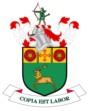
On January 9, 1974, Horwich was given a special "Town Charter." This made Horwich an official town with its own town council and a Mayor. It also received its own coat of arms.
Horwich has two main areas for the Bolton Metropolitan Borough Council: Horwich South and Blackrod, and Horwich North. Each area elects three councillors. The Horwich Town Council has eight smaller areas and elects 14 representatives.
Horwich is part of the Bolton West area for the UK Parliament. Its Member of Parliament is Phil Brickell from the Labour Party.
Geography of Horwich
Horwich covers about 3,230 acres. It stretches about 3 miles from north to south and 2 miles from west to east. The River Douglas flows along its northern edge.
To the north, the landscape is dominated by Winter Hill, Rivington Pike, and the West Pennine Moors. The highest point is 1,475 feet on the moors. The land slopes down towards the south and west.
Red Moss, located south of the town centre, is a special nature area. It's a great example of a lowland raised bog, which is a type of wetland. The Wildlife Trust for Lancashire, Manchester and North Merseyside manages this important site.
 |
Chorley, Adlington, Anderton, Lower Rivington Reservoir | Rivington, Rivington Pike | Winter Hill |  |
| Blackrod, M61 motorway | Barrow Bridge | |||
| Wigan, Aspull | Westhoughton | Lostock, Bolton |
People of Horwich (Demography)
| 2001 Census | Horwich | Bolton (borough) | GM Urban Area | England |
|---|---|---|---|---|
| Total population | 19,312 | 261,037 | 2,240,230 | 49,138,831 |
| White | 97.9% | 89.0% | 90.3% | 90.9% |
| Asian | 1.0% | 9.1% | 6.2% | 4.6% |
| Black | 0.4% | 0.6% | 1.3% | 2.3% |
| Sources: | ||||
In 2001, Horwich had 19,312 people. In 2011, the population grew to 20,067. There were 9,013 households, including many detached, semi-detached, and terraced houses.
Population Changes Over Time
Before the late 1700s, Horwich was a small farming village with only about 305 people in 1774. The Industrial Revolution brought more people to the town. But the biggest jump happened after 1885 when the locomotive works were built. The population more than tripled in just ten years!
| Population changes in Horwich since 1801 | ||||||||||||||||||||||||||||||||||||||||||||||||||||||||||||||||||||||||||
|---|---|---|---|---|---|---|---|---|---|---|---|---|---|---|---|---|---|---|---|---|---|---|---|---|---|---|---|---|---|---|---|---|---|---|---|---|---|---|---|---|---|---|---|---|---|---|---|---|---|---|---|---|---|---|---|---|---|---|---|---|---|---|---|---|---|---|---|---|---|---|---|---|---|---|
|
|
|
||||||||||||||||||||||||||||||||||||||||||||||||||||||||||||||||||||||||
| Sources: (a) Local Statistics. (b) A vision of Britain through time. (c) Neighbourhood Statistics. | ||||||||||||||||||||||||||||||||||||||||||||||||||||||||||||||||||||||||||
Economy of Horwich
Many of Horwich's old industries, like the railway works and cotton mills, closed in the late 1900s. The town started to grow again when the Toughsheet Community Stadium was built for Bolton Wanderers in 1995.
This development, called Middlebrook, brought new businesses and jobs. Companies like Hitachi, E.ON, and RBS have offices there. Georgia Pacific has a paper factory, and Halbro makes sportswear.
Horwich has large Tesco and Asda supermarkets, as well as Aldi and Iceland stores closer to the town centre. The town centre also has many smaller, unique shops, a post office, and a library.
Transport in Horwich
Public transport in Horwich is managed by Transport for Greater Manchester. The closest train stations are Blackrod and Horwich Parkway. Horwich Parkway is next to the football stadium and has a "Park and Ride" facility. Trains go to Bolton, Manchester, and Preston. The original Horwich railway station closed in 1965.
Frequent buses connect Horwich to Bolton and other nearby towns like Wigan and Preston.
Horwich is also close to the motorway network, with easy access to junction 6 of the M61 motorway. The A673 road from Bolton to Preston passes through the town.
Manchester Airport is about 50 minutes away by direct train from Horwich Parkway station.
Media in Horwich
Local news and TV shows for Horwich come from BBC North West and ITV Granada. TV signals are received from the Winter Hill TV transmitter.
Local radio stations include BBC Radio Manchester, Heart North West, and Bolton FM, a community radio station.
The Horwich Advertiser is the local newspaper. Other regional newspapers include The Bolton News and Manchester Evening News.
Education in Horwich
The Lancashire and Yorkshire Railway Company built the Railway Mechanics Institute in 1888, which later became a Technical College.
Horwich students usually attend either Rivington and Blackrod High School or St Joseph's RC High School. The oldest school building is the old Horwich Parish School, built in 1793. Horwich Parish Church of England Primary School uses a building from 1832.
Other primary schools include Our Lady's, Holy Family (now St. Mary's RC Primary School), Chorley New Road Primary, Claypool Primary, Lord Street Primary, and St Catherine's CE Primary. There is also Lever Park School, a special school, and Alliance Learning for work-based training.
| List of schools in Horwich | |||
|---|---|---|---|
| School | Type/Status | OfSTED | |
| Chorley New Road Primary School | Primary | 105178 | |
| Claypool Primary School | Primary | 105195 | |
| Horwich Parish CE Primary School | Primary | 105233 | |
| Lord Street Primary School | Primary | 105179 | |
| St Catherine's CE Primary School | Primary | 132785 | |
| St Mary's RC Primary School | Primary | 105250 | |
| Lever Park School | Special | 131692 | |
| Rivington and Blackrod High School | Secondary & Sixth form | 105261 | |
| St Joseph's RC High School | Secondary | 105262 | |
| Alliance Learning | Work-based learning | 50387 | |
Religion in Horwich
Before the English Reformation, there was a small chapel in Horwich. After the Reformation, people were encouraged to follow the Church of England. It wasn't until 1886 that the first Roman Catholic Church, St Mary's, was built in Horwich.
After the English Civil War, some people in Horwich who didn't agree with the official church (called nonconformists) held secret meetings. In 1716, the chapel was returned to the Church of England. A new church, Holy Trinity Church, was built in 1782 and rebuilt in 1831. It became the main parish church in 1853.
Other nonconformist churches, like the "New Chapel" (later the Unitarian Free Church) and various Methodist and Baptist chapels, were built in the 1700s and 1800s.
Sports in Horwich
Bolton Wanderers F.C. plays at the Toughsheet Community Stadium in Horwich. They moved there in 1997. The Bolton Arena offers indoor sports training and hosts major racket sports tournaments. It was even used for badminton events in the 2002 Commonwealth Games.
Many of Horwich's sports clubs started from the social clubs of the Horwich Locomotive Works. The Horwich RMI Harriers and Athletic Club, founded in 1924, takes part in running events. The Horwich Cycling Club, started in 1934, helps organize the Horwich Carnival Road Races in the town centre. Horwich RMI Cricket Club, founded in 1892, plays in the Bolton Cricket League.
Twin Town
In March 1990, Horwich became "twinned" with Crowborough, a town in East Sussex. This was special because they were the first towns within the United Kingdom to have a twinning agreement. They signed a charter in both Horwich and Crowborough. In 2015, they renewed their twinning agreement to celebrate 25 years.
Notable People from Horwich
See also
 In Spanish: Horwich para niños
 | James B. Knighten |
 | Azellia White |
 | Willa Brown |


