
River Douglas, Lancashire facts for kids
Quick facts for kids Douglas |
|
|---|---|

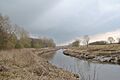
River Douglas at Appley Bridge, West Lancashire
|
|
| Country | England |
| Physical characteristics | |
| Main source | Winter Hill |
| River mouth | confluence with River Ribble 53°44′4.92″N 2°51′18.26″W / 53.7347000°N 2.8550722°W |
| Length | 56 km (35 mi) |
| Basin features | |
| Tributaries |
|
The River Douglas is a river in the north-west of England. It flows through parts of Lancashire and Greater Manchester. Sometimes, people also call it the River Asland or Astland.
The Douglas is a tributary of the River Ribble. This means it flows into the Ribble. The Douglas also has its own smaller rivers flowing into it. The main ones are the River Tawd and the River Yarrow.
A long time ago, in 1720, a special law was passed. This law allowed people to make the River Douglas wide and deep enough for small ships. This project was called the Douglas Navigation. It was finished in 1742. However, by 1783, a new, bigger waterway called the Leeds and Liverpool Canal took its place. The Douglas then went back to being a normal river. You can still see parts of the old locks (water gates) from the navigation between Parbold and Gathurst.
The river starts high up on Winter Hill in the West Pennine Moors. It flows for about 35 miles (56 km) through several towns. Then it reaches the Ribble estuary near Tarleton. The last 10 miles (16 km) or so of the river are tidal. This means the water level goes up and down with the ocean tides. In 1892, the river's path was changed in Wigan. This was done to build the Wigan Central railway station.
Contents
What's in a Name?
The name Douglas comes from old British words. Dūβ- means "black" and *glẹ:ss means "stream" or "watercourse". So, the name basically means "black stream". You can find other rivers with similar names in places like Scotland.
The River's Journey
The River Douglas begins as many small springs on Rivington Moor. These springs are high up, near the top of Winter Hill. They are known as Douglas Springs. The River Yarrow, which is a major river that joins the Douglas, also starts from springs nearby.
Close to the river's source are three large reservoirs: Anglezarke Reservoir, Upper Rivington Reservoir, and Lower Rivington Reservoir. These are part of a system called the Rivington Chain. They collect water for drinking in Liverpool. Because of these reservoirs, the natural flow of the Douglas and Yarrow rivers is changed.
The Douglas flows downhill quickly. It soon empties into the bottom of Lower Rivington Reservoir, near Horwich. Below the dam, water is released from the reservoir to keep the river flowing. This part of the river also marks the border between Greater Manchester and Lancashire.
The river then goes under the M61 motorway. It turns north-west and reaches the edge of Adlington. As it winds its way south-west, it goes under the Leeds and Liverpool Canal. The canal crosses the river on a special bridge called an aqueduct. This aqueduct was designed by John Rennie in the 1790s. It has a round arch and is made of stone.
Next, the Douglas flows into Worthington Lakes. These are three reservoirs built in the 1860s to supply drinking water to Wigan. Today, they are a country park. The river then comes out from under the reservoir dam through a tunnel. It flows east of Standish. It continues south to Wigan. In Wigan, it flows through a long tunnel under the railway near Wigan North Western station. It is crossed again by the Leeds and Liverpool Canal and then heads north-west, running very close to the canal.
The river goes under the M6 motorway and the Manchester-Southport train line near Gathurst station. It passes the village of Appley Bridge. At Parbold, the canal crosses the river for a third time. Here, the river turns north and then north-west. The aqueduct at Parbold was designed by John Longbotham and was built around 1791-1792.
At Parbold, the river is much lower. It then flows through open countryside. The River Tawd, which comes from Skelmersdale, joins it here. The Douglas becomes tidal before it reaches the village of Rufford. White Bridge in Rufford is an old stone bridge with three arches. It was built when the Douglas Navigation was being made, between 1720 and 1742.
Below White Bridge, the river channel is straighter. The Rufford Branch of the Leeds and Liverpool Canal used to join the river at Sollom Lock until 1805. A new lock was built further downstream at Tarleton. To do this, a new path was dug for the river further east, and the old river path was used for the canal. On this new section, Great Hanging Bridge is another old bridge with three arches. It carries the A581 road.
Below this bridge, the River Yarrow joins the Douglas. The Yarrow has flowed more directly from its source to this point. At Tarleton, another three-arch bridge carries the A59 road over the river. It was built in 1821. After joining the canal at Tarleton Lock, the last 4 miles (6.4 km) of the river flow into the River Ribble. This part of the river is also known as the River Asland. Boats use this section to travel between the Leeds and Liverpool Canal and the Lancaster Canal since the Ribble Link opened in 2002.
River Health and Water Flow
The reservoirs of the Rivington Chain collect water from Winter Hill. Much of this water is used for drinking in Lancashire and Greater Manchester. However, old laws mean that the water company must always let some water flow into the river below the reservoirs. This "compensation flow" helps keep the river flowing steadily all year. The river level only rises a lot if the reservoirs become completely full.
In the upper parts of the Douglas, the riverbed is quite steep. This means the river level can change very quickly after rainfall. As the river flows further west, the ground becomes flatter. Here, the water level changes more slowly.
Water is also taken from the river in two places to keep the levels up in the Leeds and Liverpool Canal. In many parts of the river, the flow is increased by water released from sewage treatment works. These are places that clean water from homes and businesses. Big treatment works are in Horwich, Wigan, and Skelmersdale (on the River Tawd).
Improvements have been made to the Wigan and Skelmersdale treatment works. These changes help make the water cleaner before it goes back into the river. In Wigan, the sewage system has also been improved. This helps reduce the amount of dirty water that sometimes flows into the river during heavy rain. In Standish, a pumping station was upgraded to reduce its impact on the river. In Horwich, volunteers helped find pollution spots in the river. The Environment Agency then followed up on these problems.
Farmers have also worked to reduce pollution from their land. This is part of a project called Catchment Sensitive Farming. It helps manage nutrients and other pollutants. Another project has improved sea defences and created new saltmarsh areas. This helps protect the coast and creates habitats for wildlife.
River Douglas Tributaries
- Longton Brook
- Centre Drain
- Carr Heys Watercourse
- Tarra Carr Gutter
- Hall Pool
- Dunkirk Dib
- Rakes Brook
- Carr Brook
- Strine Brook
- River Yarrow
- tributaries of the Yarrow listed under River Yarrow
- Main Ditch
- Eller Brook
- Wham Ditch
- Black Brook
- Abbey Brook
- New Park Brook
- Castle Brook
- Sefton Brook
- Dungeon Brook
- Dicket's Brook
*Goose Brook
- Mill Ditch
- New Reed Brook
- Bentley Brook
- River Tawd
- Slate Brook
- Grimshaw Brook
- Middlehurst Brook
- Dock Brook
- Alder Lane Brook
- Sprodley Brook
- Calico Brook
- Lees Brook
- Dean Brook
- Sand Brook
- Ackhurst Brook
- Mill Brook
- Bradshaw Brook
- Close Brook
- Barley Brook
- Smithy Brook
- Poolstock Brook
- Ince Brook
- Hawkley Brook
- Reed Brook
- Ince Brook
- Poolstock Brook
*Park Brook
- Clarington Brook
- Bradley Brook
- Bucklow Brook
- Moss Ditch
- Buckow Brook
- Hic-bibi Brook
- Stars Brook
- Hic-bibi Brook
*Almond Brook *Tunley Brook
- Pearl Brook
- Arley Brook
Checking the River's Water Quality
The Environment Agency checks the water quality of rivers in England. They give each river system an "ecological status." This rating tells us how healthy the river is for living things. It can be high, good, moderate, poor, or bad. They look at things like the types of bugs, plants, and fish in the water. They also check the "chemical status," which looks at how many chemicals are in the water. Chemical status is either good or fail.
In 2016, most parts of the River Douglas had a "moderate" ecological status. This means it was okay, but not great. The chemical status was generally "good." The lower part of the river, near the Ribble, had a "bad" ecological status.
Why wasn't the quality better? One reason is water from sewage (dirty water from homes) being released into the river. Also, the river channel has been changed a lot by humans. And sometimes, farms don't manage nutrients well, which can affect the water.
Images for kids
-

The River Douglas passing under Tarleton Bridge at Tarleton.
-
River Douglas from the gardens at Bank Hall.


