
Atherton, Greater Manchester facts for kids
Quick facts for kids Atherton |
|
|---|---|
 Market Street |
|

Atherton
|
|
| Area | 1.656 sq mi (4.29 km2) |
| Population | 22,000 |
| • Density | 13,285/sq mi (5,129/km2) |
| OS grid reference | SD672030 |
| • London | 171 mi (275 km) SSE |
| Metropolitan borough |
|
| Metropolitan county | |
| Region | |
| Country | England |
| Sovereign state | United Kingdom |
| Post town | MANCHESTER |
| Postcode district | M46 |
| Dialling code | 01942 |
| Police | Greater Manchester |
| Fire | Greater Manchester |
| Ambulance | North West |
| EU Parliament | North West England |
| UK Parliament |
|
Atherton is a town in Greater Manchester, England. It used to be part of Lancashire. The town includes areas like Hindsford, Howe Bridge, and Hag Fold. It is about 5 miles (8.0 km) south of Bolton, 7 miles (11.3 km) east of Wigan, and 10 miles (16.1 km) northwest of Manchester.
For about 300 years, starting in the 1600s, Atherton was known as Chowbent. People often shortened this to Bent, which was the town's old nickname. During the time of the Industrial Revolution, Atherton was a very important part of the Manchester Coalfield, an area known for coal mining.
Atherton has been involved with coal mining and making nails since the 1300s. This was easy because coal seams (layers of coal) were close to the surface. In the early 1900s, Atherton was described as a place full of coal mines, cotton mills, and iron factories. These industries shaped the town and its buildings.
Atherton's last deep coal mine closed in 1966. The last cotton mill shut down in 1999. Today, Atherton is the third-largest shopping area in the Borough of Wigan. Almost 20% of the people working here are in retail and wholesale. However, some manufacturing still happens in the town.
Archaeologists have found signs of a Roman road passing through the area. This road was an old route between Wigan (called Coccium by the Romans) and Manchester (called Mamucium by the Romans). After the Anglo-Saxons came to England, Atherton became part of the manor of Warrington. Later, after the Norman conquest, it became a smaller area called a township within the larger parish of Leigh. Since 1974, Atherton has been part of the Metropolitan Borough of Wigan. This is a local government area within Greater Manchester.
Contents
History
Where the Name Comes From
Atherton was first written as Aderton in the years 1212 and 1242. It was called Atherton by 1259.
There are different ideas about where the name Atherton came from. One idea is that it means the farm or village of a man named Aethelhere. Aethelhere is an old English name, and "tun" means an enclosed farm or estate. Another idea is that it comes from "adre," a Saxon word for a small brook, combined with "tun." Both ideas make sense because Atherton has several brooks (small streams) around and through it.
The Chow family lived in the valley near Chanters Brook. This part of the township became known as Chow's Bent. The meaning of "Bent" here is not clear. It might have meant a bend in the land or a slope. In the 1300s, it was called Chollebynt or Shollebent. Chowbent, or just Bent, was the name used for the main built-up part of Atherton for over 300 years, starting in the mid-1600s. Even though the population grew and the town became known as Atherton, many local people still use the names Chowbent or Bent.
Early Times
Signs of a Roman road and a Bronze Age settlement have been found in the Atherton area. The Roman road that went between Manchester and Wigan crossed Miller's Lane. Digs at the old Gadbury Brickworks, near the Gibfield Colliery site, have uncovered evidence of Roman and possibly even older settlements.
The Manor of Atherton

The land of Atherton was controlled by the Atherton family. They held it from the de Botelers family, who had their main estate in Warrington. Two members of the Atherton family, William and Nicholas, fought in the famous Battle of Agincourt in 1415.
The main house of the manor was in the southern part of the old township. Maps from the time of Elizabeth I show that there was a medieval deer park here. "Mad" Richard Atherton was the last direct male descendant of the Atherton family. He is remembered for two things. First, he made the people leave the first Atherton Chapel in 1721. Second, he built Atherton Hall, a very grand house, starting in 1723 and finishing in 1743. The driveway from the hall led to gates facing the parish church in Leigh, where the Atherton family had their own chapel.
The Atherton family's connection to the township ended when Richard Atherton died in 1726. His daughter, Elizabeth, married Robert Gwillym. Their grandson, Robert Vernon Atherton, later inherited the estate. However, the Atherton estate eventually went to Lord Lilford, who preferred to live at his family home in Northamptonshire. Lord Lilford could not afford to keep both houses. So, Atherton Hall was put up for sale. When it didn't sell, it was pulled down in 1824. Some of the smaller buildings remained and are still called Atherton Hall today. This part of Atherton became part of Leigh in 1894 and is now a public park.
Two Important Battles
During the English Civil War in 1642, the people of Chowbent were divided in their loyalties. One day, men from Chowbent were going to church in Leigh when they heard that Earl of Derby's Royalist soldiers were marching through Leigh. The Chowbent men quickly armed themselves. They fought the Earl's soldiers and pushed them back to Lowton Common. They killed some, wounded others, and captured about 200 men. One report from that time said: "...we are all upon our guard, and the Naylors of Chowbent, instead of making Nayles, have busied themselves making Bills and Battle Axes." This shows how ready they were to fight.
In 1715, during the Jacobite Uprising, supporters of the Old Pretender were marching towards Preston. General Charles Wills asked Minister Wood of Atherton Chapel to gather a group of men to help. Minister Wood led a group of Chowbent men. They were given the job of guarding a bridge over the River Ribble and a river crossing. They successfully defended these spots. The Highlanders (Jacobite soldiers) were defeated. For his efforts, Minister James Wood was given a yearly payment by Parliament and was called "The General" by his church members.
Industrial Past
Atherton, along with nearby Shakerley, was known for coal mining and making nails. Records show that nail making was happening here as early as 1332. This industry was helped by coal being easy to find near the surface. Iron was brought in from other parts of England and even Spain. Many different kinds of nails were made, along with tools like ploughs and scythes. These products were carried by pack horses to be sold in towns like Manchester and Kendal.
Over time, the nail industry grew into making nuts and bolts. Thomas Blakemore started in 1843, and by 1853, there were eight companies making nuts and bolts. Some of these companies also made parts for spinning machines used in cotton mills. The Collier Brook Bolt Works on Bag Lane, built in 1856, is still standing and is a protected historic building.
Coal had been mined in Atherton for hundreds of years from shallow shafts. But deep mining became very important in 1845 when Fletcher's Lover's Lane pit was dug at Howe Bridge. Other large mines like Gibfield Colliery and Chanters Colliery also opened. Atherton had some mining accidents. For example, in 1850, five men died in a gas explosion at Gibfield. In 1957, eight men died in a gas explosion at Chanters Colliery. Chanters Colliery closed in 1966, which marked the end of deep coal mining in Atherton. In 1913, the first pit head baths in the country were opened at Gibfield. These baths allowed miners to wash after their shifts.

The cotton mills grew from a home-based spinning and weaving industry. As factories with powered machines became common, local weavers felt their jobs were threatened. In 1812, a group of people called Luddites broke machines and burned down a new factory in nearby Westhoughton.
Cotton mills were built in Atherton. James Burton built mills on both sides of the Hindsford Brook, including Lodge Mill. Howe Bridge Spinning Mills, the largest group of mills in Atherton, started in 1868. The last mill there was built in 1919. It stopped being a textile factory in 1999. Other mills like Laburnum Mills (built 1905) and Ena Mill (built 1908) also closed in the late 1900s. Ena Mill, with its tall chimney, is now a protected building and has been changed for other uses. It reminds us of the town's textile past.
Governance

Atherton is part of the Metropolitan Borough of Wigan. It is divided into two areas called electoral wards: Atherton North and Atherton South with Lilford. Each ward chooses three councillors to represent them on the Wigan local council.
Historically, Atherton was part of a larger area called the Hundred of West Derby in Lancashire. It was also one of six townships that made up the ancient parish of Leigh. The Atherton family controlled the manor of Atherton.
In the past, laws about helping the poor meant Atherton was part of the Leigh Poor Law Union. This group managed workhouses, including one in Atherton. In 1863, Atherton got a local board of health. This group was in charge of keeping the town clean and healthy. In 1894, part of Atherton joined Leigh Urban District. The rest became Atherton Urban District. This urban district was ended in 1974. Since then, Atherton has been part of the Metropolitan Borough of Wigan.
Some people in Atherton have felt that they have more in common with nearby Bolton and Salford than with Wigan. This feeling has led to some independent councillors being elected in Atherton.
Geography
| Weather chart for Atherton | |||||||||||||||||||||||||||||||||||||||||||||||
|---|---|---|---|---|---|---|---|---|---|---|---|---|---|---|---|---|---|---|---|---|---|---|---|---|---|---|---|---|---|---|---|---|---|---|---|---|---|---|---|---|---|---|---|---|---|---|---|
| J | F | M | A | M | J | J | A | S | O | N | D | ||||||||||||||||||||||||||||||||||||
|
70
6
1
|
50
7
1
|
60
9
3
|
50
12
4
|
60
15
7
|
70
18
10
|
70
20
12
|
80
20
12
|
70
17
10
|
80
14
8
|
80
9
4
|
80
7
2
|
||||||||||||||||||||||||||||||||||||
| temperatures in °C precipitation totals in mm |
|||||||||||||||||||||||||||||||||||||||||||||||
|
Imperial conversion
|
|||||||||||||||||||||||||||||||||||||||||||||||
Atherton is located about 171 miles (275 km) northwest of central London. It is 5 miles (8.0 km) east of Wigan and 10.7 miles (17.2 km) west-northwest of Manchester. It sits at the eastern end of the Metropolitan Borough of Wigan.
The town, including Hindsford, Howe Bridge, and Hag Fold, is mostly low-lying. The soil in much of the area is clay. The southwest part of the town is about 100 feet (30 m) above sea level, rising to 250 feet (76 m) in the north. Atherton has seven brooks (small streams) flowing through it. The Shakerley Brook forms the western border. Chanters Brook flows through an area called "The Valley." Other brooks include Knight's Brook, Colliers Brook, Small Brook, Westhoughton Brook, and Red Waters Brook. Underneath the town are the coal measures, which are layers of coal from the Manchester Coalfield.
Atherton has a mild climate, similar to the rest of Greater Manchester. The average highest and lowest temperatures are a bit warmer than the national average. The yearly rainfall is higher than average, and the amount of sunshine is a bit lower.
The town is on an old main road, which is now the A579 from Bolton to Leigh. The A577 also runs from Atherton to Tyldesley in one direction and to Wigan in the other.
 |
Westhoughton | Over Hulton | Little Hulton | |
| Hindley | Shakerley | |||
| Leigh | Leigh | Tyldesley |
Population and People
| Atherton Compared | ||||
|---|---|---|---|---|
| 2001 Census | Atherton | Wigan MB | GM Urban Area | England |
| Total population | 20,302 | 301,415 | 2,240,230 | 49,138,831 |
| White | 98.5% | 98.7% | 90.3% | 90.9% |
| Asian | 0.5% | 0.4% | 6.2% | 4.6% |
| Black | 0.2% | 0.2% | 1.3% | 2.3% |
| Source: Office for National Statistics | ||||
In 2001, Atherton had a total population of 20,302 people. There were slightly more females (51.2%) than males (48.8%). These people lived in 8,745 homes. The town covered an area of about 429 hectares (1,060 acres). This means there were about 47.32 inhabitants per hectare (19.15/acre) people per hectare, which is higher than the average for the wider Greater Manchester area. The average age of people in Atherton was 40.
Most people in Atherton (96.29%) were born in England. A smaller number were born elsewhere in the United Kingdom (1.56%) or other parts of the world.
Regarding religious beliefs in 2001, most people (86.6%) said they were Christian. About 7.2% said they had no religion.
Population Changes Over Time
| Population growth in Atherton 1777–2001 | |||||||||||
|---|---|---|---|---|---|---|---|---|---|---|---|
| Year | 1777 | 1801 | 1811 | 1821 | 1831 | 1841 | 1851 | 1861 | 1871 | 1881 | 1891 |
| Population | 2,200 | 3,249 | 3,894 | 4,145 | 4,181 | 4,475 | 4,659 | 5,907 | 7,531 | 12,602 | 15,833 |
| Year | 1901 | 1911 | 1921 | 1931 | 1939 | 1951 | 1961 | 1971 | 1981 | 1991 | 2001 |
| Population | 16,211 | 18,982 | 19,856 | 19,989 | 20,098 | 20,596 | 19,756 | no data | 22,032 | 21,696 | 20,302 |
|
Parish 1777–1861 • Township 1871–1891 • Urban District 1901–1961 • Urban Subdivision 1981–2001 |
|||||||||||
Economy
Atherton is part of the wider Manchester area where people travel for work.
In 2001, 8,755 people (43.1% of residents) in Atherton had jobs. Many of them (19.65%) worked in shops and wholesale businesses. Another large group (19.28%) worked in manufacturing, making things. About 10.27% worked in health and social care.
The census also showed how people aged 16–74 were involved in the economy. About 36.7% had full-time jobs, and 11.0% had part-time jobs. Some people were self-employed (6.8%) or unemployed (4.0%). The unemployment rate of 4.0% was a bit higher than the national average of 3.3% at that time.
In 2001-2002, the average household income in Atherton was £380 per week. This was less than the average for the rest of the North West region. On average, each household owned about one car or van. About 43.74% of homes had one vehicle, and 30.76% had none.
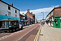
Atherton is the third-largest shopping area in the Wigan Borough. It has a small shopping centre for pedestrians. Most shops are on Market Street and are often small, independent businesses. There is also a supermarket that helps bring shoppers to the town centre. Around the town centre, there are older, more affordable homes, mostly terraced houses.
Nuts and bolts are still made in Atherton by Smith Bullough. This is one of the few companies left in the UK that makes these items. A new business park is planned for the old Gibfield Colliery site.
Landmarks

Atherton has several important historic buildings. Some of these are in the area known as Chowbent. They include Alder House from the 1600s, Chowbent Chapel, St John the Baptist's Church (built 1879), and Chanters Farmhouse. All of these are protected historic buildings. The name "Chanters" comes from a special church grant given in 1360. This name is also used for a bridge and a former coal mine.
Near the parish church, there is a tall, pointed stone monument called an obelisk. It looks like ancient Egyptian structures. It was probably built for Robert Vernon Atherton in 1781. It was repaired in 1867, before the church was even finished. This obelisk is also a protected historic structure.
Between 1873 and 1875, the mine owners Fletcher Burrows built a small model village at Howe Bridge. This village had cottages, shops, a club, and a bath house for their workers. This Victorian village, along with St Michael and All Angel's Church, is now a special conservation area. The Ena Mill, one of Atherton's large cotton spinning mills, still stands with its chimney. It reminds us of the town's textile industry.
Atherton's war memorial is a cenotaph (a monument for those who died in war). It is located where Leigh Road and Hamilton Street meet. It was designed by architect Arthur John Hope and made of Darley Dale stone. It was officially revealed in January 1922 by a soldier who was blinded in the First World War.
Transport
The road from Bolton to Leigh became a turnpike (a toll road) around 1770. A toll gate was put on Bolton Road at the edge of Atherton. Shakerley Lane was another toll road built to move coal from the Shakerley mines to the main turnpike road.
In 1825, the Bolton and Leigh Railway was approved. This single-track railway opened in 1828. It brought the railway to the western side of Atherton, near the coal mines at Howe Bridge and Gibfield. Train stations opened at Atherton Bag Lane and Atherleigh. The line connected to the Liverpool and Manchester Railway in 1831. It also connected to the Tyldesley–Wigan line in 1883, when a station called Chowbent opened. This station was later renamed Howe Bridge in 1901. The Lancashire and Yorkshire Railway's line from Manchester to Southport passes north of Atherton. Atherton Station, which opened in 1887–88, is still open today.

In 1900, a plan was approved to build over 62 miles (100 km) of tramways in southern Lancashire. The South Lancashire Electric Traction and Power Company took over the project. The first part of the tramway opened in 1902, connecting Lowton to Four Lanes Ends, passing through Leigh and Atherton. This company later became Lancashire United Transport (LUT). LUT had its main office and a large depot in Howe Bridge. On December 16, 1933, the last tram ran from Leigh to Four Lane Ends. The next day, trolley buses took over the routes.
Public transport in Atherton is managed by Transport for Greater Manchester. You can travel by train from Atherton and Hag Fold stations to Wigan and Manchester. These services are run by Northern.
Buses in Atherton go to places like Bolton, Leigh, Wigan, Manchester, the Trafford Centre, and Middlebrook Retail and Leisure Complex. From September 2023, these services became part of the Manchester Bee Network.
Local Bus Services:
- V2: Atherton - Tyldesley - Salford - Manchester
- 132: Atherton - Tyldesley - Worsley - Trafford Centre
- 132: Atherton - Hindley Green - Hindley - Ince - Wigan
- 516: Atherton - Westhoughton - Horwich - Middlebrook
- 516: Atherton - Westleigh - Leigh
- 582: Atherton - Howe Bridge - Leigh
- 582: Atherton - Over Hulton - Daubhill - Bolton
- 583: Atherton - Hag Fold - Tyldesley
- 583: Atherton - Leigh
Education
The first school in Atherton was Chowbent Grammar School, which started before 1654. Chowbent Chapel School followed in 1734. Many other schools opened in the 1800s, including Lane Top National School (1840), Chowbent Unitarian School (1860), and Howe Bridge School (1869).
In the 1890s, a technical school opened for science and art. Later, Hesketh Fletcher Senior School opened in 1967 but closed in 2011. Atherton High School opened in 2012.
| School | Locality | Description | Ofsted | Website |
|---|---|---|---|---|
| Atherton St George's C.E. Primary School | Atherton | Primary school | 130300 | website |
| Chowbent Primary School | Atherton | Primary school | 106443 | website |
| Hindsford C.E. Primary School | Hindsford, Atherton | Primary school | 106441 | website |
| Meadowbank Primary and Nursery School | Atherton | Primary school | 106425 | website |
| Parklee Community School | Atherton | Primary school | 106426 | website |
| Sacred Heart R.C. Primary School | Hindsford, Atherton | Primary school | 106499 | website |
| St Michael's C.E. Primary School, Howe Bridge | Howe Bridge, Atherton | Primary school | 106478 | website |
| St Philip's C.E. Primary School | Atherton | Primary school | 106515 | website |
| St Richard's Catholic Primary School | Atherton | Primary school | 106498 | website |
| Hesketh Fletcher C.E. High School (closed) | Atherton | Secondary school | 106536 | website |
| Rowan Tree Primary School (Formerly New Greenhall School) | Atherton | Special school | 131295 | website
[1] |
Religion

There have been three chapels or churches on the site of the Parish Church of St John the Baptist. The first chapel was built in 1645. It was used by Presbyterians. In 1721, Richard Atherton made the Presbyterians leave. The chapel was then made an official church in 1723. A new chapel was built on the same spot in 1814. The current church, dedicated to St John the Baptist, was officially opened in 1879. The church is made of Runcorn stone. It is 60 feet (18 m) wide and 127 feet (39 m) long. Its square tower is 120 feet (37 m) tall. The church building has been affected by ground sinking due to mining.
The New Bent or Chowbent Chapel was the first Nonconformist (Protestant churches not part of the Church of England) chapel in Atherton. It was built in 1721 and opened in 1722 by the Presbyterian community after they were forced out of the first chapel.
St Anne's Church, Hindsford started as a small mission in a barn. A new church building was built in 1901. It has since been changed into homes. St Michael and All Angels at Howe Bridge was built in 1877.
Atherton also has churches for other Christian groups, including Wesleyan, Baptist, Independent Methodist, and Primitive Methodist. A Congregational church in Howe Bridge opened in 1904.
Roman Catholics used to hold services in a room above a pub. Then, Sacred Heart Church opened in Hindsford in 1869. The land for the church was given by Lord Lilford. Sacred Heart Church closed in 2004. Its community, along with others, is now part of a larger Catholic community named after St Margaret Clitherow.
Sport
Atherton opened swimming baths in Mayfield Street in 1902. A swimming club was started there. The baths closed in 2005. The Atherton & Leigh Amateur Swimming Club moved to the new Leigh Sports Village in 2008.
Atherton has two semi-professional football teams. The oldest is Atherton Collieries A.F.C., formed in 1916. They play in the Northern Premier League. The other team is Atherton Laburnum Rovers F.C., which plays in the North West Counties Football League. There is also Atherton Town FC.
Atherton Cricket Club was formed in 1872. They have been part of the Bolton and District Cricket Association since 1921.
Public Services
The Greater Manchester Police force patrols Atherton from the Atherton Police Station. This station covers Atherton, Tyldesley, Astley, and Mosley Common. It is one of five police areas within the Wigan division.
The fire and rescue service for Atherton is provided by the Greater Manchester Fire and Rescue Service from the Atherton fire station.
Health services in the Wigan area are managed by the Wigan Borough Clinical Commissioning Group. Hospitals are run by the Wrightington, Wigan and Leigh NHS Foundation Trust. They have an Accident and Emergency service at Wigan's Royal Albert Edward Infirmary and outpatient clinics at Leigh Infirmary.
Waste management (rubbish collection) is handled by the Wigan Authority.
Electricity for Atherton is supplied by Electricity North West Ltd. United Utilities manages the town's drinking water and wastewater.
Culture
The Atherton Botanical Garden Club started in 1850. Today, it is a social club. In the past, it held talks, study groups, and walks for its members.
A public library opened in 1905 with money from Andrew Carnegie. Bent Chapel already had a library and gave 4,000 books to the new town library. Central Park, a 10-acre (4.0 ha) public park, was created in 1912. Other parks were later made in Lodge Lane, Hindsford, and Devonshire Place. The local council also took over the grounds of Howe Bridge Welfare in 1963.
In the early and mid-1900s, Atherton had three cinemas: the Gem, the Savoy, and the Palace. An amateur photography club was formed in 1938. Formby Hall, which was pulled down in 2018, used to host the Bent 'n' Bongs Beer Festival every January.
Notable Residents
Several important ministers of Chowbent Chapel lived in Atherton. One was James Wood (1672–1759), known as "the General," who was important during the Battle of Preston in 1715.
Thomas Walker Horsfield (1792–1837) was a historian and writer. Joseph Nightingale (1775–1824), born in Chowbent, was a writer and preacher.
Eric Laithwaite (1921–1997) was an engineer who helped develop the linear induction motor and Maglev (magnetic levitation) train system. Author Lemn Sissay grew up and lived in Atherton. Chess grandmaster Nigel Short also grew up in Atherton and went to St Philip's School.
Architect Arthur John Hope (1875–1960) was born and lived in Atherton. He was a partner in a well-known architectural firm. Edward Ormerod, a mining engineer at Gib Field Colliery, invented an important safety device for mines called the Ormerod detaching hook.
Actor Andrew Whyment from Coronation Street lives in Atherton. Keely Hodgkinson, who won an Olympic gold medal in the 800m race in 2024, was raised in Atherton. UFC Interim Heavyweight Champion Tom Aspinall was also raised in Atherton.
Images for kids
-
Market Street
