Tyldesley facts for kids
Quick facts for kids Tyldesley |
|
|---|---|
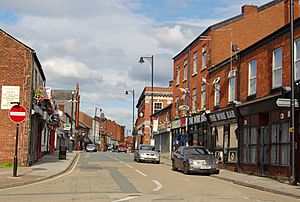
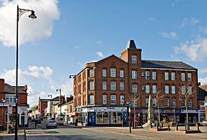 Marklands Buildings and Elliott Street |
|
| Population | 16,142 (2011 Census) |
| OS grid reference | SD690023 |
| • London | 170 mi (274 km) SE |
| Metropolitan borough |
|
| Metropolitan county | |
| Region | |
| Country | England |
| Sovereign state | United Kingdom |
| Post town | MANCHESTER |
| Postcode district | M29 |
| Dialling code | 01942 |
| Police | Greater Manchester |
| Fire | Greater Manchester |
| Ambulance | North West |
| EU Parliament | North West England |
| UK Parliament |
|
Tyldesley (pronounced "Til-slee") is a market town in Greater Manchester, England. It's located in the Metropolitan Borough of Wigan. Historically, it was part of the county of Lancashire. Tyldesley is about 8 miles (13 km) southeast of Wigan and 9 miles (14 km) northwest of Manchester. In 2011, about 16,142 people lived here.
Long ago, a Roman road passed through Tyldesley, connecting ancient Roman towns. After the Norman Conquest in 1066, Tyldesley became a small area called a "township."
During the Industrial Revolution, Tyldesley grew a lot because of factories and textile manufacture. Many people moved here to work in the cotton mills and coal mines. In the 20th century, these industries slowed down. Now, Tyldesley has changed, with new homes and businesses, especially along Elliott Street.
Contents
History of Tyldesley
What's in a Name?
The name Tyldesley comes from Old English words. It means "Tilwald's clearing," suggesting that this area was once a forest clearing belonging to someone named Tilwald. The name was first written down as Tildesleiha in 1210.
Tyldesley is on the edge of the Lancashire Plain. There's a sandstone ridge called "the Banks," which is where the Pennines hills begin. This gave the town its old name, Tildsley Banks. The land here goes from about 100 feet (30 meters) high to 250 feet (76 meters) at its highest point. Locals sometimes call Tyldesley "Bongs."
Early Times
A Roman road used to run through this area, connecting Roman camps at Wigan (called Coccium) and Manchester (called Mamucium). In 1947, two pots filled with about 550 Roman bronze coins were found near Tyldesley. These coins, made between AD 259 and AD 278, are now in the British Museum.
After the Romans left Britain, not much was written about Tyldesley. But we know Saxons lived here because of place names ending in leah, like Tyldesley, Shakerley, and Astley.
Old Manor Houses
The main manor house was Astley Hall. In 1212, it belonged to Hugh Tyldesley, who was the lord of the manors of Astley and Tyldesley. The Tyldesley family was known for having arguments with their neighbors.
Another important house was Garrett Hall, which stayed with the Tyldesley family until 1652. Later, it was sold to other families and used by tenant farmers.
There were other important houses too. The Shakerley family lived in Shakerley Old Hall. Chaddock Hall was home to a family of farmers called yeomen. Archers from Chaddock fought in famous battles like Crécy in 1346 and the Battle of Agincourt in 1415.
Cleworth Hall was another old house. In 1594, it was linked to a witchcraft trial. Two children living there were said to be "possessed by evil spirits." A man named Edmund Hartley was asked to cure them. He was later tried and found guilty of witchcraft and was hanged.
The Banks Estate Develops
In the early 1700s, Tyldesley was just a few cottages and farms. There was no church or inn. Then, in 1728, a merchant named Thomas Johnson bought the Banks Estate. He bought more land and helped develop the town of Tildsley Banks. You can still see his name in Squires Lane and Johnson Street.
The late 1700s saw a building boom. The town center was planned with a grid layout. The first inns, the Flaming Castle and the Green Dragon, opened in the late 1770s. Rows of brick houses were built for workers moving to the new factories.
The Industrial Revolution in Tyldesley
Before the Industrial Revolution, Tyldesley was mostly farms. People spun and wove cloth like muslin at home. After 1827, silk weaving became popular.
In 1772, Thomas Johnson opened a small factory for processing cotton. Later, bigger mills were built, using water from local brooks for steam power. By 1838, James Burton owned most of the town's mills. His company even owned houses and a pub for his workers.
Caleb Wright owned Barnfield Mills, which employed about 800 people. One of his mills, Barnfield No 6, was built in 1894. It was a large, multi-story mill for spinning cotton. This mill was torn down in the 1990s, and a supermarket now stands there.
Coal mining was also very important. People had been digging for coal in Shakerley since at least 1429.
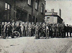
After the railway opened in 1864, coal mining became the main industry. Many collieries (coal mines) surrounded the town for over 100 years. Some of the big mining companies included Bridgewater Collieries and Astley and Tyldesley Collieries. Most mines closed after the Second World War.
Mining could be dangerous. The worst disaster happened at Yew Tree Colliery in 1858, when an explosion killed 25 miners. Other explosions and accidents also caused deaths in local mines.
Grundy's Foundry was another important business, making metal products. Its founder, John Grundy, invented a warm air heating system used in churches.
After the industries declined, the town changed. Old factory sites were cleaned up, and new houses were built. But the town center still feels like a busy market town, with its refurbished market square.
How Tyldesley is Governed
Historically, Tyldesley was part of a larger area called the Hundred of West Derby. It was one of six townships that made up the ancient parish of Leigh.
In 1863, Tyldesley got a local board of health to manage local services. This board took over the gas works, built the first swimming baths, and opened Tyldesley Cemetery. In 1894, Tyldesley became an "urban district" with its own elected council.
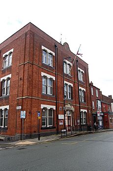
Tyldesley Town Hall was originally a club, but the council took it over in 1924. The council also opened Tyldesley Park in 1902 and a library in 1909, helped by money from Andrew Carnegie. After the World Wars, the council built new homes.
In 1974, Tyldesley became part of the Metropolitan Borough of Wigan, which is part of Greater Manchester. Today, Tyldesley is an electoral "ward" within Wigan, meaning it elects three local councillors.
For national politics, Tyldesley is part of the Leigh area, which elects a Member of Parliament (MP) to the UK Parliament.
Tyldesley's Geography
 |
Westhoughton | Bolton | Little Hulton |  |
| Hindsford, Atherton | Boothstown | |||
| Leigh | Astley | Barton Moss |
| Weather chart for Tyldesley | |||||||||||||||||||||||||||||||||||||||||||||||
|---|---|---|---|---|---|---|---|---|---|---|---|---|---|---|---|---|---|---|---|---|---|---|---|---|---|---|---|---|---|---|---|---|---|---|---|---|---|---|---|---|---|---|---|---|---|---|---|
| J | F | M | A | M | J | J | A | S | O | N | D | ||||||||||||||||||||||||||||||||||||
|
70
8
2
|
70
8
2
|
50
10
3
|
63
13
5
|
51
16
8
|
58
19
10
|
54
21
12
|
69
21
12
|
63
18
10
|
88
14
7
|
82
10
4
|
79
7
2
|
||||||||||||||||||||||||||||||||||||
| temperatures in °C precipitation totals in mm |
|||||||||||||||||||||||||||||||||||||||||||||||
|
Imperial conversion
|
|||||||||||||||||||||||||||||||||||||||||||||||
Tyldesley is located about 7.7 miles (12.4 km) east-southeast of Wigan and 8.9 miles (14.3 km) west-northwest of Manchester. It's at the eastern end of the Metropolitan Borough of Wigan.
The town is on the edge of the Lancashire Plain, just north of Chat Moss. The "Banks of Tyldesley" are where the foothills of the Pennines begin. The land rises from about 100 feet (30 meters) to 250 feet (76 meters) high. These banks are a sandstone ridge about one and a half miles long.
Underneath the ground are coal measures (layers of coal) from the Manchester Coalfield, covered by clay. Small streams like the Shakerley and Hindsford Brooks flow through the area, eventually joining the River Mersey.
Even though it was very industrial in the past, Tyldesley is now mostly a residential area. The main road, the A577, runs along the high ground where the town center is.
Population and Economy
Who Lives in Tyldesley?
In 2001, Tyldesley had a population of 34,022. There were slightly more females than males. About 27.3% of people over 16 were single, 47.8% were married, and 8.2% were divorced.
About 24% of households were one-person homes, and 46.1% were married couples living together. Many people in Tyldesley have academic qualifications, with fewer people lacking them compared to the wider Wigan area.
How People Make a Living
In 2001, the main jobs for people aged 16–74 in Tyldesley were in:
- Retail and wholesale (18.1%)
- Manufacturing (16.5%)
- Property and business services (12.1%)
- Health and social work (10.9%)
- Education (7.4%)
Compared to the rest of England, fewer people in Tyldesley worked in agriculture. Most jobs are found in areas like Chaddock Lane and Parr Brow.
Landmarks of Tyldesley
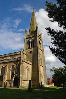
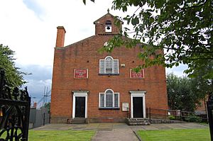
In the past, Tyldesley's skyline was full of factory chimneys and coal mine structures. Now that these industries are gone, the main landmarks are St George's Church and Top Chapel in the Market Square. Both are old, important buildings.
St George's Church is one of the few stone buildings in town, with a spire that reaches 150 feet (46 meters) high. Most buildings in Tyldesley are made of brick.
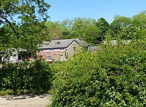
Other important old buildings include Chaddock Hall and Damhouse (also known as Astley Hall). Chaddock Hall is a private home, while Damhouse is now a heritage center.
Getting Around Tyldesley
Edward Entwistle, who was born in Tyldesley in 1815, was the driver of the world's first scheduled passenger train between Liverpool and Manchester.
In 1864, a railway line opened through Tyldesley, with a station in the town. This line, called the Tyldesley Loopline, closed in 1969.
In 1902, Tyldesley got its first trams. Because the streets were narrow, trams had to follow a one-way system. Eastbound trams went along Shuttle Street and Milk Street, while westbound trams used Elliot Street and Castle Street. This one-way system is still used by cars today. In 1931, trolley buses replaced the trams.
Today, bus services connect Tyldesley to nearby towns. A special guided busway was built on the old railway trackbed, opening in 2013. It has several stops in Tyldesley and a path for walkers, cyclists, and horse riders alongside it.
Education in Tyldesley
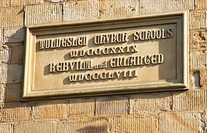
The first national school in Tyldesley opened in 1827 near St George's Church. It taught children of all ages. Over the years, many other schools opened and closed, including church schools and a British School.
Today, the main primary schools are St George's Central Primary School, Tyldesley Primary School, and Garrett Hall Primary.
For secondary education, the main school is Fred Longworth High School. Children from Tyldesley also attend other high schools in the area, such as St Mary's Catholic High School in Astley.
Religion in Tyldesley
John Wesley, a famous religious leader, preached in Shakerley several times in the 1700s. This helped start places of worship in the area.
Tyldesley's first church, Top Chapel, was built in 1789 in the Market Square. It was built for a group called the Countess of Huntingdon's Connexion. Thomas Johnson gave the land, and Lady Huntingdon helped pay for it. It's called Top Chapel because it's on the highest point in Tyldesley.
Before 1825, Tyldesley didn't have its own official church. People had to travel to nearby towns for baptisms, marriages, and burials.
St George's Church was built in 1825 on land donated by Thomas Johnson. It was paid for by the British Parliament after the victory at the Battle of Waterloo. The church was designed by Robert Smirke and consecrated (made sacred) on September 19, 1825. It can seat 1,100 people, is 112 feet (34 meters) long, and its spire is 150 feet (46 meters) high.
Over time, many other types of churches and chapels were built in Tyldesley, including those for Methodists, Baptists, and Welsh congregations.
Sports in Tyldesley
The idea for a public swimming baths came from mill owner Caleb Wright. The baths opened in Union Street in 1876. The Tyldesley Swimming Club was formed right away. Two members of the Tyldesley Swimming and Water Polo Club, Addin Tyldesley and Duncan Cleworth, even competed in the Olympic Games! The old baths closed in 1960, and a former cinema was turned into a new public pool in 1964, which is now the Pelican Centre.
Before 1895, Tyldesley had a rugby union team called Tyldesley FC. After a split in English rugby, the club became one of the first members of the Northern Rugby Football Union (now Rugby league). The club later rejoined rugby union and still plays today.
Long-distance runner Fred Norris, who worked in a local coal mine, competed in the 1952 and 1956 Olympic Games.
Culture and Community
As an industrial town, Tyldesley had many places for entertainment, like cinemas and pubs. Films were shown in the Miners' Hall from 1908. Three cinemas were built: the Theatre Royal, the Carlton, and the Majestic.
In 1902, the council created a public park. A public library was built in 1908 with help from Andrew Carnegie.
Tyldesley also has a long history of music. The Tyldesley Good Templars Band was the town's first brass band, formed in 1877. Today, the Tyldesley Band is still active.
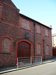
Tyldesley Little Theatre is home to an amateur dramatic society. It's a small theater with 150 seats. The town's industrial past was captured in paintings by artist Roger Hampson in the 1960s and 1970s. In 2022, Tyldesley got its first community radio station, Radio M29.
Public Services
The Greater Manchester Police force provides policing for Tyldesley from Atherton Police Station. Fire and rescue services come from Leigh and Atherton fire stations. Health services are managed by the Wigan Borough Clinical Commissioning Group, and hospital services are provided by the Wrightington, Wigan and Leigh NHS Foundation Trust.
Waste management is handled by Wigan Metropolitan Council. Electricity is supplied by Electricity North West, and United Utilities manages Tyldesley's drinking water and wastewater.
Notable People
- Ella Toone (born 1999), a professional footballer.
- Lord James Blears (1923–2016), a professional wrestler.
- Frederick Norris (1921–2006), a British long-distance runner.
See also
 In Spanish: Tyldesley para niños
 | Mary Eliza Mahoney |
 | Susie King Taylor |
 | Ida Gray |
 | Eliza Ann Grier |


