Astley, Greater Manchester facts for kids
Quick facts for kids Astley |
|
|---|---|
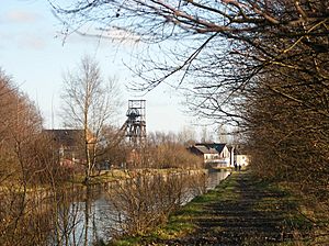 Bridgewater Canal and Astley Green pithead |
|
| Population | 11,270 |
| OS grid reference | SD699006 |
| • London | 163 mi (262 km) SE |
| Metropolitan borough |
|
| Metropolitan county | |
| Region | |
| Country | England |
| Sovereign state | United Kingdom |
| Post town | MANCHESTER |
| Postcode district | M29 |
| Post town | WARRINGTON |
| Postcode district | WA3 |
| Dialling code | 01942 |
| Police | Greater Manchester |
| Fire | Greater Manchester |
| Ambulance | North West |
| EU Parliament | North West England |
| UK Parliament |
|
Astley is a village in Greater Manchester, England. It's part of the Metropolitan Borough of Wigan. The village is crossed by the Bridgewater Canal and the A580 East Lancashire Road. Astley is close to Tyldesley and is located about 8 miles (13 km) from both Wigan and Manchester. In 2011, the Astley Mosley Common area had a population of 11,270 people.
Astley's name comes from Old English words. It likely means "east (of) Leigh" or "eastern wood or clearing." For many centuries, Astley was a small area within the larger parish of Leigh. The village was first written about in 1210. This was when its local lord gave land to a religious group called the Premonstratensian canons.
During the Middle Ages and later, important people lived at Damhouse, the main house of the area. The village grew around this house. The Bridgewater Canal reached Astley in 1795, and the Liverpool and Manchester Railway arrived in 1830. The Industrial Revolution brought big changes. A cotton mill was built in 1833, and Coal mining became a very important industry.
Later, coal mining slowed down, and the last coal was dug in 1970. The cotton mill also closed in 1955. Today, the Astley Green Colliery Museum helps people learn about Astley's industrial past.
Contents
History
What's in a Name?
The name Astley comes from Old English. It means "East Leigh," because of its location compared to the town of Leigh. The word "Leigh" means a "wood," a "clearing," or a "meadow." The earliest time Astley was written down was in 1210. Back then, it was spelled Asteleghe. Other old spellings include Asteleye (1292) and Astlegh (14th and 15th centuries).
Astley's Early Days
The oldest signs of people living here are parts of an old Roman road. This road connected Roman army camps in Wigan and Manchester. It ran north of Astley, near Tyldesley. We know that Anglo-Saxons lived in this area because of place names like Leigh, Tyldesley, and Astley. These names often end with leah, meaning a clearing in the woods.
The Manor House Story
Astley became a small area within the parish of Leigh during the early Middle Ages. It was first mentioned in 1210. This was when Hugh of Tyldesley, who owned the lands of Tyldesley and Astley, gave some land to Cockersand Abbey. In 1212, he lived at Astley Hall. This was the main house for both Astley and Tyldesley.
His family owned the Astley manor until 1353. Then, Richard Radcliff bought it. The Radcliff family lived there until 1561. After that, the land went to Anne, who married Gilbert Gerard.
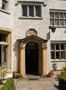
In 1606, a rich man named Adam Mort bought the manor house and land in Astley. He built the first Astley Chapel in 1631. This chapel was a smaller church for the main parish church in Leigh. He also built a grammar school that stood for over 200 years. Adam Mort's grandson, also named Adam, rebuilt Damhouse in 1650. You can still see his initials carved above the front door. The house was named after a stream that was dammed to power a mill nearby.
Adam Mort's family continued to support the chapel and school. They lived at Damhouse until 1734. Later, in 1893, the Leigh Hospital Board bought Damhouse. They used it as a hospital for people with diseases like diphtheria and scarlet fever. It became a general hospital in 1948 but closed in 1994.
The Industrial Age
Astley became more industrial in the early 1800s. Before this, most people worked in farming or made cloth at home. In 1833, James and Robert Arrowsmith built a cotton mill near the Bridgewater Canal. This factory meant fewer people worked from home. The Arrowsmith's factory closed in 1955 because mining caused damage to its foundations. This ended Astley's connection to the textile industry.
Astley was also part of the Lancashire Coalfield, so it had several coal mines. An old map from 1768 shows a "Coal Road" leading to mines like Nook and Gin Pit. Gin Pit's name comes from a "horse gin," a machine used to lift coal.
On May 7, 1908, the Pilkington Colliery Company began digging the first shaft of Astley Green Colliery. This mine was near the Bridgewater Canal. Coal was moved by a special railway or by the canal to power stations. In 1939, there was a mining accident at Astley Green where five men died. Women, called "pit brow lasses," worked at the mine sorting coal until 1955. The last coal was brought up on April 3, 1970.
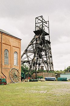
The tall headgear at Astley Green Colliery Museum is still a famous sight today. It was built in 1912 and is almost 98 feet (30 meters) high. Inside the winding house, you can see a huge steam engine that helped lift the coal.
How Astley is Governed
For a long time, Astley was part of a larger area called the Hundred of West Derby in Lancashire. It was also one of six small areas that made up the old parish of Leigh. In 1866, Astley became its own civil parish. Later, in 1933, it joined the Tyldesley Urban District.
In 1974, the local government changed. Astley became part of the Metropolitan Borough of Wigan, which is in Greater Manchester. Since 2004, Astley and Mosley Common form an electoral ward. This ward chooses three councillors to represent them on the Wigan council. As of 2012, these councillors were from the Labour Party.
For national elections, Astley is part of the Worsley and Eccles parliamentary area. This area elects one Member of Parliament (MP) to the UK Parliament.
Astley's Location and Nature
| Weather chart for Astley | |||||||||||||||||||||||||||||||||||||||||||||||
|---|---|---|---|---|---|---|---|---|---|---|---|---|---|---|---|---|---|---|---|---|---|---|---|---|---|---|---|---|---|---|---|---|---|---|---|---|---|---|---|---|---|---|---|---|---|---|---|
| J | F | M | A | M | J | J | A | S | O | N | D | ||||||||||||||||||||||||||||||||||||
|
70
8
2
|
70
8
2
|
50
10
3
|
63
13
5
|
51
16
8
|
58
19
10
|
54
21
12
|
69
21
12
|
63
18
10
|
88
14
7
|
82
10
4
|
79
7
2
|
||||||||||||||||||||||||||||||||||||
| temperatures in °C precipitation totals in mm |
|||||||||||||||||||||||||||||||||||||||||||||||
|
Imperial conversion
|
|||||||||||||||||||||||||||||||||||||||||||||||
Astley is located about 163 miles (262 km) northwest of central London. It sits on the northern edge of the Chat Moss bog, about 177 feet (54 meters) above sea level. Astley is connected to Tyldesley to the north. It is considered part of the Greater Manchester Urban Area, which is the second-largest built-up area in the United Kingdom.
Astley is about 8.3 miles (13.4 km) west-northwest of Manchester city centre. The Bridgewater Canal runs just south of the village. The A572 road and A580 roads also cross Astley from east to west. The hamlet of Astley Green is south of the village.
Astley covers an area of about 2,685 acres (10.87 km²). About 1,000 acres (4.0 km²) of this is peat bog. Astley and Bedford Mosses is a special nature area. It's one of the last parts of Chat Moss that hasn't been drained. This area is a Site of Special Scientific Interest (SSSI) because of its unique nature. Astley Moss has small streams like Astley Brook and Moss Brook.
The ground beneath Astley has different types of rock. The top layers are a mix of clay and sand. Smaller areas within Astley include Blackmoor, Astley Green, Gin Pit, and Cross Hillock. Gin Pit is a small group of houses built for coal miners.
 |
Atherton | Tyldesley | Walkden |  |
| Leigh | Boothstown | |||
| Culcheth | Chat Moss | Barton upon Irwell |
Population Facts
| Population growth in Astley from 1881 to 1931 | |||||||||||
|---|---|---|---|---|---|---|---|---|---|---|---|
| Year | 1881 | 1891 | 1901 | 1911 | 1921 | 1931 | |||||
| Population | 2,669 | 2,552 | 2,823 | 3,556 | 3,902 | 4,584 | |||||
|
Astley CP/Ch |
|||||||||||
Astley's Economy
In the past, Astley's economy was all about textile factories and coal mines. These industries grew a lot during the Industrial Revolution. Today, the main place for jobs is the Chaddock Lane Industrial Estate.
Since the 1980s, many new houses have been built between Tyldesley and Astley. Most people in Astley own their homes. Some parts of Astley are very well-off, while other areas, like Blackmoor, have more social housing. The village has a small shopping area in Blackmoor. The Astley Green Colliery Museum and the heritage center at Damhouse also bring visitors to the area.
Important Landmarks
The Astley Green Colliery Museum is a very important historical site. Its engine house and tall headgear are still standing. You can see them from far away.
Damhouse, the old manor house, is a listed building. Parts of it date back to 1595. The house was made bigger in 1650. In 1999, a group called Morts Astley Heritage Trust was formed. They work to protect Damhouse and open the nearby woods to the public.
Morleys Hall is on land that was given to Cockersand Abbey in 1210. It was once owned by the Morleys family. In 1540, it was described as a timber house on stone foundations, surrounded by a moat. It was rebuilt in 1804, but some old parts remain. Today, Morleys Hall is a private home.
Getting Around Astley
Public transport in Astley is managed by Transport for Greater Manchester. Buses connect Astley to places like Farnworth, the Trafford Centre, Tyldesley, Atherton, Wigan, and Manchester. Major roads, like the A580 "East Lancashire Road," also cross through the village. This road opened in 1934.
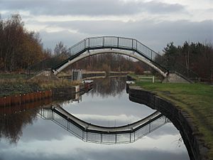
The Bridgewater Canal reached Astley in 1795. This canal helped bring trade to Astley Green. The Hope and Anchor Inn (now the Boathouse) was built there for people and horses pulling canal barges.
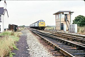
The Liverpool and Manchester Railway, built in 1830, also crosses Astley Moss. The railway track was built on a special base of branches and cotton bales to stop it from sinking into the bog. Early trains could go up to 25 miles per hour (40 km/h). Astley railway station was built in the mid-1840s.
Learning in Astley
Adam Mort started a grammar school next to the chapel in 1631. It was used until 1833. Children from poor families could go for free. A national school opened in 1841 on land given by Captain Durie of Damhouse. Meanleys Infant School opened in 1904 for the children of mining families at Gin Pit.
| School | Locality | Description | Website |
|---|---|---|---|
| St. Stephen's C.E. Primary | Astley | Primary school | website |
| Tyldesley Primary | Astley | Primary school | website |
| St. Ambrose Barlow Catholic Primary | Astley | Primary school | website |
| Holy Family Roman Catholic Primary | Boothstown | Primary school | website |
| St Mary's Catholic High | Astley | Secondary school | website |
Places of Worship
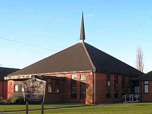
Adam Mort built Astley Chapel, which was finished in 1630. It was the first of three chapels in Astley. The chapel was rebuilt in 1760 and made bigger several times. Sadly, the church was destroyed by fire on June 18, 1961. Many old books and memorials were lost. A new church was built nearby.
Some Catholic families in the Leigh area kept their faith after the English Reformation. Secret Catholic services were held in private homes, like Morleys Hall. In 1641, a Catholic priest named Ambrose Barlow was arrested during a service at Morleys Hall. He was later executed. He is now a saint in the Roman Catholic Church. A church and school in Astley are named after him. The St Ambrose Barlow parish was created in 1965, and the church was built in 1981.
There were also two Methodist churches, but one in Lower Green closed in 2009.
Sports and Activities
The Astley and Tyldesley Miners' Welfare Club at Gin Pit is a hub for several sports groups. These include the Astley and Tyldesley Football Club, Astley and Tyldesley Cricket Club, and the Astley and Tyldesley Roadrunners. The Astley and Tyldesley Cycle Speedway Club started in 1989. They built a race track at the Miners' Welfare Club in 1991.
Public Services
The Greater Manchester Police force from Atherton Police Station keeps Astley safe. The Greater Manchester Fire and Rescue Service provides fire and rescue help from Leigh and Atherton fire stations. Hospital services are provided by the Wrightington, Wigan and Leigh NHS Foundation Trust. They have an Accident and Emergency service at Wigan Hospital. Waste management is handled by Wigan Metropolitan Council. Electricity is supplied by Electricity North West Ltd. United Utilities manages Astley's drinking water and wastewater.
 | Leon Lynch |
 | Milton P. Webster |
 | Ferdinand Smith |


