
Chat Moss facts for kids
Quick facts for kids Chat Moss |
|
|---|---|
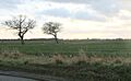
 Along Astley Road |
|

Chat Moss
|
|
| Area | 10.6 sq mi (27 km2) |
| OS grid reference | SJ713963 |
| Metropolitan borough |
|
| Metropolitan county | |
| Region | |
| Country | England |
| Sovereign state | United Kingdom |
| Post town | MANCHESTER |
| Postcode district | M44,M29,M17,WN7,WA3 |
| Dialling code | 0161 |
| Police | Greater Manchester |
| Fire | Greater Manchester |
| Ambulance | North West |
| EU Parliament | North West England |
| UK Parliament |
|
Chat Moss is a huge area of peat bog located in Greater Manchester, England. It stretches across parts of the Salford, Wigan, and Trafford. It also reaches into the St Helens area in Merseyside and Warrington in Cheshire. This large bog is about 5 miles (8 km) west of Manchester, covering an area of about 10.6 square miles (27.5 km2).
Scientists believe Chat Moss started forming about 7,000 years ago. However, peat (decayed plant material) began to build up here even earlier, around 10,000 years ago, after the last ice age ended. The peat is very deep, ranging from 24 to 30 feet (7 to 9 m). A lot of work has been done to turn this bog land into useful land, especially in the 1800s. Even today, many drainage channels are needed to stop the land from turning back into a bog.
Today, much of Chat Moss is used for farming, though farming in the area is becoming less common. A 228-acre (92 ha) part of Chat Moss, called Astley and Bedford Mosses, was made a special protected area in 1989. This area, along with nearby Risley Moss and Holcroft Moss, is also a European Union Special Area of Conservation, known as Manchester Mosses.
Chat Moss was a big problem for building the Liverpool and Manchester Railway. George Stephenson, a famous engineer, managed to build a railway line through it in 1829. He did this by "floating" the line on a base of heather and branches covered with tar and stones. This was a huge achievement! The M62 motorway, finished in 1976, also crosses the bog. The A580 road crosses it too, marking the boundary between areas like Leigh and Warrington.
Contents
History of Chat Moss
The name Chat Moss might come from St Chad, a bishop from the 600s. But it could also come from the Celtic word ced, meaning "wood," because the area was once a big lake surrounded by trees. Another idea is that it comes from an Old English name, Ceatta, and mos, meaning "swamp." In old records, it was called Catemosse in 1277 and Chatmos in 1322. Locally, "moss" is the word for a peat bog.
Daniel Defoe, a famous writer, visited Chat Moss in 1724. He described it as a "great bog or waste" that was "frightful to think of." He noted that you couldn't cross it on horseback or on foot unless it was very dry. He wondered why nature created such a "useless production."
Sometimes, peat bogs can burst, especially after heavy rain. This seems to have happened at Chat Moss in the 1500s. John Leland, who wrote during the time of King Henry VIII, described how Chat Moss "brast up" (burst open). It destroyed land and polluted rivers, carrying smelly water and moss all the way to the shores of Wales, the Isle of Man, and even Ireland!

Building the Liverpool and Manchester Railway in 1826 was a huge challenge because of Chat Moss. Engineers needed a very strong base for the railway tracks. George Stephenson was in charge. His first idea was to dump a lot of material into the bog until it reached the bottom. But the bog was too liquid, and the material just flowed away. The final solution was to build the line on a "floating" base of wood and stone. This was seen as a "great triumph of engineering." The first train crossed Chat Moss in 1830, and the railway line is still used today.
Reclaiming the Land

The first serious attempt to reclaim (make useful) Chat Moss began in the early 1800s. In 1793, William Roscoe started working on a smaller bog nearby called Trafford Moss. By 1798, he was ready to lease part of Chat Moss, but the actual work didn't start until 1805.
The methods for reclaiming the land changed over time. But three main steps were always involved:
- Digging drains to remove water.
- Building roads to bring in materials like clay, lime, or marl to make the soil firmer.
- Adding fertiliser, often human waste collected from nearby towns, to help plants grow.

For Chat Moss and Trafford Moss, a clever idea was used instead of regular roads. They built a temporary light railway with narrow tracks. This spread the weight of the wagons evenly across the bog. The tracks could be moved and relaid as needed. William Roscoe went bankrupt in 1821, but others continued his work.
Between 1831 and 1851, the population of Manchester grew a lot. This created a big problem with rubbish disposal. By the 1880s, Manchester produced over 200,000 tons of rubbish each year, with about 75% being human waste. In 1895, Manchester Corporation bought 2,502 acres (1,013 ha) of Chat Moss to use it as a rubbish disposal site.

Rubbish was carried on barges along the Manchester Ship Canal to a wharf. From there, it was loaded onto a light railway and taken into the moss for dumping. Farmers on Chat Moss had to accept a certain amount of rubbish on their land as part of their rental agreement. They even had to pay for it! This helped them reclaim more land for farming. Dumping human waste on Chat Moss stopped in 1923, but general rubbish continued to be dumped until 1966.
Once the land was drained, made stable, and fertilised, Chat Moss became excellent farmland. It supplied Manchester with salads and other vegetables. The drainage channels, which are still needed today, give the area its unique flat look with ditches instead of hedges or walls. Even with all the work, some parts of Chat Moss are still wild and remote.
During the Second World War, a plan was made to protect cities from enemy bombs. This involved lighting fake fires on open land nearby. Manchester had four of these "Starfish sites," and two were on Chat Moss. These sites had shelters for the crew and devices to make it look like streetlights or bombs exploding. They were used from 1941 to 1943.
Worsley Man
In August 1958, workers digging peat in Chat Moss near Worsley found the head of a man. He was thought to be between 26 and 45 years old when he died. Tests showed he was a Romano-British Celt and died around 121 to 251 AD, during the late Iron Age. The Worsley Man is now kept at the Manchester Museum.
Geography and Nature
Chat Moss is located at the southern edge of the Lancashire Plain. This area has Bunter sandstones and marls from the Late Triassic period. On top of these rocks is a layer of boulder clay left behind by the last ice age about 10,000 years ago. Because the land is flat and has this clay underneath, many peat bogs formed along the Mersey Valley. The bogs between the River Glaze in the west and Worsley and Eccles in the east are known as Chat Moss.

Chat Moss is a type of bog called a lowland raised bog. In areas where water doesn't drain well, plants decay slowly, creating peat. Over many years, this peat can build up and raise the level of the bog higher than the land around it. Chat Moss covers about 10.6 square miles (27.5 km2). It is about 5 miles (8 km) long and 2.5 miles (4.0 km) wide at its widest point, and it sits 75 feet (23 m) above sea level. Most of Chat Moss is in Salford, but it also extends into Wigan. By the 1990s, about 72% of the bog had been turned into farmland. About 230 acres (93 ha) of damaged bog remain, with 766 acres (310 ha) of untouched peat in four former peat mining sites. The peat is very deep, between 24 feet (7 m) and 30 feet (9 m).
The main types of bog moss found in Chat Moss are Sphagnum cuspidatum, S. imbricatum, and S. acutifolia.
A 228-acre (92 ha) part of Chat Moss, called Astley & Bedford Mosses, was made a Site of Special Scientific Interest in 1989. This area, along with Risley Moss and Holcroft Moss, is also a European Union Special Area of Conservation, known as Manchester Mosses.
The main natural areas in the moss are bog, heathland, woodland, and acidic grassland. These areas are wetter or drier depending on the local drainage. The remaining bog areas are mostly covered by common cottongrass and hare's-tail cottongrass. Bog mosses are rarer but can be found in patches. As the peat has become drier, areas have been taken over by purple moor grass and downy birch trees.
Chat Moss is also home to several bird species. It's especially important for raptors like the hen harrier, short-eared owl, and merlin in winter. Birds like the curlew and long-eared owl also breed here. There's a large heronry (a place where herons nest) in Botany Bay Wood, which is the biggest woodland area in Greater Manchester.
Waste dumped on Chat Moss in the past led to high levels of heavy metals like lead and copper in the soil. This raised concerns about crops grown there. However, the soil's high pH (how acidic or alkaline it is) stops these metals from moving around and being absorbed by the crops.
Economy and Future
Chat Moss has the largest area of prime farmland in Greater Manchester, but farming there is decreasing. In 2003, out of 54 farms on the moss, only three were growing vegetables. Others had switched to growing crops like corn, turf, or keeping horses. Chat Moss also has the largest area of natural woodland in Greater Manchester.
Most of the area is now Green Belt land. This means there are rules about what kind of buildings and developments can happen there. Some areas are still used for digging up peat for commercial use. However, Salford City Council wants to turn some of these areas back into wet mossland. Permission for peat digging ended in 2010. In 2011, Salford Council decided not to renew the permission, and a court order stopped further digging. A public inquiry in 2012 supported the council's decision, and commercial peat digging on Chat Moss has now stopped.
See also
Images for kids
-
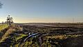
Along Astley Road
-
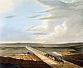
View of the railway across Chat Moss, 1833
-

A traveller's sketch of the train at Chat Moss, November 1857
-
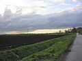
Part of Chat Moss known as Irlam Moss, showing the typical landscape of drainage ditches instead of hedges
-
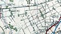
A 1937 map of Chat Moss
-
View across Chat Moss towards the village of Glazebrook
