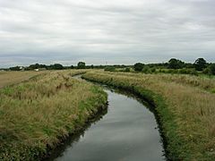
Glaze Brook facts for kids
Quick facts for kids Glaze Brook |
|
|---|---|

The Glaze Brook
|
|
| Country | England |
| Region | North West England |
| District | Wigan, Greater Manchester, Warrington, Cheshire |
| Physical characteristics | |
| Main source | Confluence of Pennington / Moss brooks |
| River mouth | River Mersey |
The Glaze Brook, also known as the River Glaze, is a small river in Greater Manchester, England. It flows for about 22 miles (35 kilometers). From Lately Common, which is south of Leigh, all the way to the River Mersey, the Glaze Brook forms the border between Greater Manchester and Cheshire.
This river gets its water from several smaller streams. These are called tributaries. Some of its main tributaries include the Astley, Bedford, Hey, Pennington, Shaw, and Westleigh Brooks.
Contents
Where the Glaze Brook Starts
The Glaze Brook begins where two smaller streams meet. These streams are the Pennington Brook and the Moss Brook. This meeting point is about 120 meters north of Hawkhurst Bridge.
The Journey of Pennington Brook
The Pennington Brook starts at the outflow of Pennington Flash. This flash (which is a type of lake) is near Aspull Common. Pennington Flash gets its water from Hey Brook. Hey Brook is actually a continuation of Borsdane Brook, which flows south from Blackrod.
How Glaze Brook Flows
After the Glaze Brook starts, it collects water from other streams. One of these is the Bedford Brook, which flows south from Leigh. It also gets water from the Black or Moss Brook, which comes from Worsley and flows west through Chat Moss.
After picking up these waters, the Glaze Brook turns southward. Eventually, it flows into the River Mersey. It joins the section of the River Mersey that is part of the Manchester Ship Canal near Cadishead.
The Land Around the River
The area that the Glaze Brook and its tributaries drain is mostly flat farmland. This area is called the river's catchment. The highest point in this lowland area is about 158 meters above sea level.
The river flows through land that is mainly used for farming. However, its smaller streams extend into areas that used to have a lot of mining and factories. In these old mining areas, the ground sometimes sinks. This sinking has created lakes, which are called "flashes." You can find these flashes at Pennington and Westleigh.
The ground beneath the river and its surroundings is made up of sandstone and coal. These layers are part of the Lancashire Coalfield.
What are Tributaries?
A tributary is a stream or river that flows into a larger stream or river. Think of it like smaller branches joining a main tree trunk. These smaller waterways bring water from a wider area into the main river.
Main Tributaries of Glaze Brook
The Glaze Brook has many tributaries that feed into it. Here are some of the important ones:
- Willow Brook
- Jibcroft Brook
- Carr Brook
- Black/Moss Brook
- Bedford Brook
- Lilford Park Brook
- Atherton Lake Brook
- Lilford Park Brook
- Bedford Brook
* Atherton Brook ** Collier Brook * Hindsford Brook ** Shakerley Brook *** Old Mill Brook **** Cutacre Brook ** Chanters Brook *** Carr Brook
-
-
- Pen Leach Brook
- Town Brook
- Astley Brook
- Elennor Brook
- Astley Brook
-
* Honksford Brook
-
- Whitehead Brook
- Stirrup Brook
- Ellen Brook
- Stirrup Brook
- Shaw Brook
- Whitehead Brook
- Pennington Brook
- Hey Brook
- Westleigh Brook
- Small Brook
- Marsh Brook
- Westleigh Brook
- Hey Brook
* Cunningham Brook ** Pennington Brook
-
-
-
- Hall Lee Brook
- Windy Bank Brook
- Nan Holes Brook
- Coffin Lane Brook
- Borsdane Brook
- Dog Pool Brook
-
-
 | Aurelia Browder |
 | Nannie Helen Burroughs |
 | Michelle Alexander |

