Cheshire Plain facts for kids
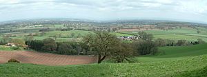
The Cheshire Plain is a large, mostly flat area of land. It is almost entirely within the county of Cheshire in North West England. This plain stretches from the River Mersey in the north to the Shropshire Hills in the south. It is surrounded by hills. To the west are the hills of North Wales. To the north-east are the foothills of the Pennines. The Wirral Peninsula is to the north-west. The plain also connects with the South Lancashire Plain near Manchester.
Contents
What is the Cheshire Plain?
The Cheshire Plain is the surface of something much deeper. It sits above the Cheshire Basin. This is a very deep area filled with layers of sediment (like sand, mud, and rocks). This basin stretches north into Lancashire and south into Shropshire.
How the Plain Formed
The plain got its current shape a long time ago. This happened between 20,000 and 15,000 years ago. Back then, huge sheets of ice covered the land. This was during the last glacial period (the last Ice Age). As the ice melted, it left behind a thick layer of glacial till. This is a mix of clay, sand, gravel, and boulders. It also left large areas of sand and gravel. These materials were carried and dropped by the melting ice and water.
What the Plain Looks Like
Most of the Cheshire Plain is used for dairy farming. This means you will see many fields with hedgerows (lines of bushes or small trees). These hedgerows divide the fields. This gives the plain a very green and organized look.
The "Cheshire Gap"
Weather experts often call the lowlands of the Cheshire Plain the Cheshire Gap. This "gap" is a natural pathway. It lies between the Clwydian Range of hills in Wales and the Peak District and South Pennines hills. Weather systems often travel through this gap. This allows them to move much further inland from the Irish Sea coast than in other places.
See also
 In Spanish: Llanura de Cheshire para niños
 | Kyle Baker |
 | Joseph Yoakum |
 | Laura Wheeler Waring |
 | Henry Ossawa Tanner |


