
Chew Valley, Greater Manchester facts for kids
Quick facts for kids Chew Valley Reservoir |
|
|---|---|
 |
|

Chew Valley Reservoir
Location in Greater Manchester
|
|
| Location | Greater Manchester |
| Coordinates | 53°31′N 1°57′W / 53.51°N 1.95°W |
| Type | Reservoir |
| Primary inflows | Chew Clough, Green Grain, Dry Clough, South Clough |
| Primary outflows | Chew Brook |
| Basin countries | United Kingdom |
Chew Valley is a beautiful area in Saddleworth, Greater Manchester, England. It's known for its stunning moorland landscapes and important reservoirs. The valley follows the path of the Chew Brook, which flows from the hills of Black Chew Head down to join the River Tame near Greenfield. Part of this valley, including the large Dovestone and Chew reservoirs, is actually inside the Peak District National Park.
Chew Reservoir: A High Achievement
One of the most interesting features of Chew Valley is the Chew Reservoir. It was finished in 1912. At the time, it was the highest reservoir ever built in England, sitting about 1,600 feet (488 meters) above sea level!
To build the reservoir's dam, workers had to transport a huge amount of clay – over 42,000 cubic yards (about 32,000 cubic meters). This clay was used to create a strong, watertight core for the dam. To move all this material, a special tram-road was built right through Chew Valley.
Today, the old tram and railway lines are gone. But their route has been turned into a popular long-distance walking path called the Oldham Way. You can even find reconstructed bridges with signs that share information, pictures, and maps about the valley's history.
-
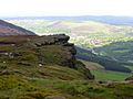
Wimberry Rocks in the Chew Valley
-
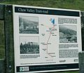
Sign showing ownership of the valley by United Utilities and old maps of the tram that once ran through the valley
-
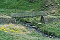
Oldham Way footpath, Chew Valley


Chew Brook: The Valley's Lifeline
The Chew Brook starts as a small stream high up on the western slopes of Black Chew Head. This hill is the highest point in Greater Manchester. As the brook flows westward down the slope, it gets bigger as other small streams join it, like the Black Chew Grain.
After flowing for about 1 kilometer through marshy moorland, the brook empties into the Chew Reservoir. This reservoir, built in 1912, was once the highest in England. (Today, the Cow Green reservoir in County Durham holds that record).
From the western end of Chew Reservoir, the brook flows down a narrow, steep valley. It curves northwest for about 2.3 kilometers before reaching another large body of water: Dovestone Reservoir.
After leaving Dovestone, the Chew Brook becomes a small river. It winds its way through the heart of Greenfield village. The journey of Chew Brook ends a short distance below Greenfield railway station, where it merges into the larger River Tame.
