Brown Knoll facts for kids
Quick facts for kids Brown Knoll |
|
|---|---|

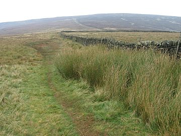
Looking towards Brown Knoll
|
|
| Highest point | |
| Elevation | 569 m (1,867 ft) |
| Prominence | 36 m |
| Parent peak | Kinder Scout |
| Listing | Dewey, TuMP |
| Geography | |
| Location | Derbyshire, England |
| Parent range | Peak District |
| OS grid | SK083851 |
| Topo map | OS Landranger 110; OL1W |
Brown Knoll is one of the highest hills in the Peak District in central England. It stands about 569 meters (1,867 feet) high. This makes it a significant landmark in the area. It's located near the top of the Edale valley and is about 3 kilometers (2 miles) southwest of Kinder Scout, which is the highest point in the Peak District.
What is Brown Knoll Like?
Brown Knoll has a rounded top and no trees. It is covered in moorland plants, like tough grasses and heather. These plants are common in high, open areas.
Paths and Trails
There are several paths around Brown Knoll. A main track runs near the top, connecting the Pennine Way and the Pennine Bridleway. These are long-distance walking and riding trails. Another smaller path branches off this main track. It crosses the very top of Brown Knoll and then goes southeast towards other hills. These hills line the southern side of the Edale valley.
Open Access Land
The area around Brown Knoll is known as "Open Access land." This means that people can freely walk and explore here. It's a great place for hiking and enjoying nature. However, it is not part of the National Trust's High Peak Estate.
 | Delilah Pierce |
 | Gordon Parks |
 | Augusta Savage |
 | Charles Ethan Porter |

