Elmley Lovett facts for kids
Quick facts for kids Elmley Lovett |
|
|---|---|
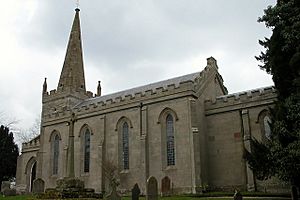 St Michael's church is a grand and medievalesque reconstruction of a much earlier church, such as its centuries-old spire |
|
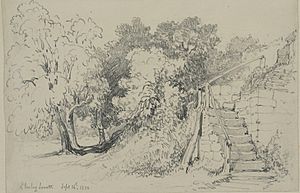 Steps and trees at Elmley Lovett, sketched in 1850 |
|
| Area | 7.82 km2 (3.02 sq mi) |
| Population | 334 (2021 census) |
| • Density | 43/km2 (110/sq mi) |
| Civil parish |
|
| District |
|
| Shire county | |
| Region | |
| Country | England |
| Sovereign state | United Kingdom |
| Post town | Droitwich |
| Postcode district | WR9 |
| EU Parliament | West Midlands |
| UK Parliament |
|
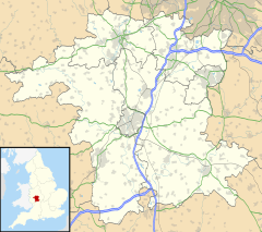
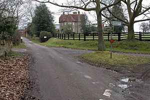
Elmley Lovett is a small village in Worcestershire, England. It is a civil parish where homes are spread out. You'll find them especially east of the Hartlebury Trading Estate. A smaller area called Cutnall Green is also part of Elmley Lovett.
Cutnall Green has a pub, a farm shop, and continues into the nearby parish of Elmbridge. The village is about 5 miles (8 km) northwest of Droitwich. Cutnall Green is a bit closer, about 4 miles (6.4 km) away.
The name "Elmley Lovett" means "clearing of the elm trees." The "Lovett" part was added in the 1200s. This happened after the Lovett family became landowners through marriage.
A special type of snowdrop flower is named after Elmley Lovett. It is called Galanthus elwesii 'Elmley Lovett'. The village has a long history and many old historical sites.
Contents
St Michael's Church
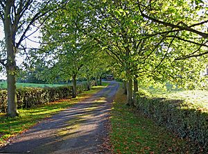
The old stone church of St Michael has been restored many times. It features four tall, narrow windows on each side of its main hall. It also has a modest bell tower topped with a tall stone spire. The church is surrounded by tall trees.
The church was largely rebuilt in 1840. However, it still has parts from the 1300s and 1400s. The church and its graveyard are not officially listed as historic by Historic England. Church records for the parish began in 1539. This church has a special covered gateway called a lychgate from 1924. It also has a kissing gate in its grounds.
From 1908 to 1925, a famous missionary and Japanese language expert, Philip Fyson, was the church's rector.
Elmley Lovett's Long History
Early Times and Roman Finds
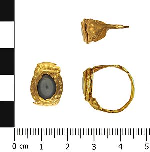
Elmley Lovett is where a collection of Roman coins was found. This collection included six Roman silver coins dating from 115 BC to 37 AD. One of them was a rare silver coin of Brutus. A Roman gold finger-ring was also found here. It dates back to the 200s AD.
In the Domesday Book of 1086, Elmley Lovett was recorded in Worcestershire. It had 30 households at that time. The area was also surrounded by woods and close to large forests. In 1086, three watermills in Elmley Lovett used the River Salwarpe.
The settlement of Elmley Lovett was first recorded in the 800s. By 1086, it had a priest, ten plough teams, three mills, and a large wooded area. This area was part of the Forest of Ombersley until about 1230. The land was eventually sold by the King to Sir Robert Acton in 1543. He was a local judge and former High Sheriff of Worcestershire.
In the 1600s, a new manor house was built. This might have been when the older moated house was left empty. The new house was south of the church. It stood until 1890 when it was taken down. Today, you can still see parts of its walls and a 1600s dovecote.
Life in the 1600s
Elmley Lovett appears in records from the 1600s. These records show how taxes were collected and how men were called up for military service. In 1621, the manor was divided among the four daughters of Sir John Acton. Elizabeth, one of these daughters, married Henry Townshend. He bought out the other daughters' shares.
Henry Townshend's diary (from 1640-1663) is a very important historical document. It tells us a lot about the 1600s. Henry Townshend supported the King during the English Civil War.
His diary begins in 1640 with soldiers being called up for the army. Elmley Lovett was one of the parishes that helped with this effort. Records show how much tax Elmley Lovett had to pay in 1629, 1641, and 1642. The amounts increased significantly over these years.
In 1640, Elmley Lovett's local officer, William Penn, was told to raise money for the army. He asked each family in the parish to pay £7 10 shillings. This was their part of a larger amount of money being raised. On April 22, 1640, three men from Elmley Lovett were chosen to join the army.
In January 1642, Elmley Lovett had to pay another £10 8 shillings and three pence. This time, 52 people were taxed, including three widows. The church's rector, Mr Edward Best, was also taxed. In August 1644, Elmley Lovett had to support Captain William Sandys and his 100 men. This cost the parish £11 4 shillings.
By October 1645, the Parliamentary army demanded £10 monthly from Elmley Lovett. They threatened to "pillage, and plunder, and your houses fired" if the money wasn't paid. In 1649, Elmley Lovett's share of a large national tax was £20.
The Moule family, who lived at Snead's Green House, were important landowners from the 1620s until the late 1800s.
From the 1800s to Today
The Elmley Lovett Volunteers were a group of soldiers from Worcestershire. They were formed to fight against Emperor Napoleon. In 1808, the Elmley Lovett Infantry had 66 members. A metal button with a crown and the letters ELV has been found.
A study of working-class people from 1790-1841 found that Elmley Lovett was a fairly wealthy parish. However, officials who helped the poor were strict in the 1820s. The study also noted that the two fee-paying schools in Elmley Lovett were not very good. They were poorly supplied, badly taught, cold, and grim.
In 1829, a major lawsuit happened between the church's rector, Rev Lynes, and a local person, Mr Lett. The lawsuit was about tithes, which were payments made to the church. The rector won the case.
In 1868, Elmley Lovett was described as being next to the small areas of Bellington and Snead's Green. The church's rectory (the rector's house) was worth £527 each year. By then, almost all of the church had been rebuilt, except for its old spire. The church had six bells.
On the north wall of St Michael's church, there is a war memorial. It remembers those who fought in the First World War (1914-1918).
During the Second World War (1939–45), people from the Royal Air Force (RAF) base at Hartlebury worshipped at St Michael's Church. A brass memorial plaque and an RAF flag were given to the church to honor this connection.
Deserted Medieval Village
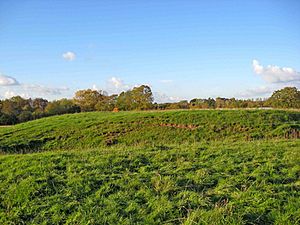
Around St Michael's churchyard, you can find the remains of a deserted medieval village. This means it was a village that people left long ago. It is now a scheduled monument, which protects its historical importance. We don't know exactly why people left, but they might have moved to Cutnall Green.
Near the church are the remains of a moated manor house. This was a large house surrounded by a ditch filled with water. Today, the moat is dry and about 2.5 meters (8 feet) deep. About 200 meters (650 feet) south of the church, you can see parts of the walls of a mansion built in 1635. This mansion was taken down in 1890. It might have replaced the older moated manor house.
South and west of the church, there are banks and ditches. These are the remains of up to four houses with their yards and gardens. South of these, you can see irregular fenced areas. These were likely used for keeping animals or for farming. There are also at least three old pathways. They run from the current road, eastwards across these old earthworks, towards the moated site and the church.
Heritage Listings
Elmley Lovett, including Sneads Green, has 20 different places listed as historic by Historic England. These listings help protect important old buildings and sites. Some of these include:
- The Churchyard Cross, south of St Michael's Church.
- The Aaron memorial, southeast of the church.
- A dovecote (a building for doves) southeast of the Old Rectory.
- Stone House and The Old Rectory.
- The Church of St Michael (which has a Grade II* listing, meaning it's very important).
- A house 50 meters east of the church.
- Cow House northwest of Lake Farmhouse.
- Swallow Cottage.
- Gate and gateposts south of Moat House.
- A barn north of Lake Farmhouse.
- Walton Cottages 1 & 2 at Pye Hill.
- Sneadgreen House and Caloow Cottage in Sneads Green.
- An outhouse south of Holly Orchard in Sneads Green.
- Green End Cottage in Sneads Green.
- Newhouse Farmhouse.
- Moat House.
- The medieval remains (from the deserted village).
- St Michael's Churchyard itself.
 | May Edward Chinn |
 | Rebecca Cole |
 | Alexa Canady |
 | Dorothy Lavinia Brown |


