
Welland facts for kids
Quick facts for kids
Welland
|
||
|---|---|---|
| City of Welland | ||

The Welland Civic Square
|
||
|
||
| Nickname(s):
The Rose City
|
||
| Motto(s):
Where Rails and Water Meet
|
||

Location of Welland in the Niagara Region
|
||

Welland
Location in Southern Ontario
|
||
| Country | Canada | |
| Province | Ontario | |
| Region | Niagara | |
| Settled | 1788 | |
| Incorporated (village) | 1858 | |
| Incorporated (city) | 1917 | |
| Area | ||
| • Land | 81.04 km2 (31.29 sq mi) | |
| Elevation | 175.30 m (575.13 ft) | |
| Population
(2021)
|
||
| • Total | 55,750 | |
| • Density | 645.3/km2 (1,671/sq mi) | |
| Time zone | UTC−5 (Eastern (EST)) | |
| • Summer (DST) | UTC−4 (EDT) | |
| Forward Sortation Area |
L3B, L3C
|
|
| Area code(s) | 905 / 289 / 365 / 742 | |
| Highways | ||

Welland is a city in the Regional Municipality of Niagara in Southern Ontario, Canada. In 2021, about 55,750 people lived here.
The city is in the middle of the Niagara region. It's only a half-hour drive to places like Niagara Falls, Niagara-on-the-Lake, St. Catharines, and Port Colborne. Welland is known as the place "where rails and water meet". This refers to the railways connecting Buffalo to Toronto and Southwestern Ontario. It also refers to the Welland Canal and Welland River. These waterways were very important for the city's growth. Welland has grown on both sides of the Welland River and Welland Canal, which link Lake Erie and Lake Ontario.
Contents
History of Welland
Early Settlement and the War of 1812
The Welland area was first settled in 1788. These settlers were United Empire Loyalists. They received land from the Crown because they lost property in the British Thirteen Colonies during and after the American Revolutionary War.
Tensions grew between Great Britain and the new United States. This led to the War of 1812. On October 19, 1814, Canadian forces met American soldiers near where Welland is today. This was the Battle of Cook's Mills. After a tough fight, the Americans went back to Buffalo, New York. This battle was one of the last in the War of 1812 on Canadian land.
The Welland Canal's Influence
The First Welland Canal was extended in 1833 to reach Lake Erie. This canal has shaped Welland's growth ever since. A wooden bridge, called an aqueduct, was built to carry the Welland Canal over the Welland River. This spot is now downtown Welland and was simply called Aqueduct. A lock was also built to let boats move between the canal and the river. A small town quickly grew around this area. It offered services to travelers and workers on the canal.
The town was later named Merrittsville. This was in honor of William Hamilton Merritt, who started the Welland Canal project. The Merrittville Highway (Niagara Road 50) still carries his name. It was the main north-south road in central Niagara before Highway 406 was built. Welland got its current name when it became an official village on July 25, 1858. It became a city in 1917.
Industrial Growth and Changes
Welland was one of the few places where railways crossed the canal. These two things helped heavy industry grow in Welland. In 1906, the Plymouth Cordage Company opened the first big industrial plant here. By the 1930s, Welland was a major industrial city and was growing fast.
By the 1960s, the city was getting too big for the canal to pass through its center. The Welland By-Pass project started in 1967 and finished in 1973. This project moved the Welland Canal away from downtown Welland to the city's edge. The new route was also shorter. After the bypass was finished, Welland's east side became like an island between the old and new canal channels.
Today, the City of Welland is working to make its downtown area better. They have plans to encourage new businesses and development.
Welland's Population
| Historical populations | ||
|---|---|---|
| Year | Pop. | ±% |
| 1871 | 1,110 | — |
| 1881 | 1,870 | +68.5% |
| 1891 | 2,035 | +8.8% |
| 1901 | 1,863 | −8.5% |
| 1911 | 5,318 | +185.5% |
| 1921 | 8,654 | +62.7% |
| 1931 | 10,709 | +23.7% |
| 1941 | 12,421 | +16.0% |
| 1951 | 15,382 | +23.8% |
| 1961 | 36,079 | +134.6% |
| 1971 | 44,397 | +23.1% |
| 1981 | 45,448 | +2.4% |
| 1991 | 47,914 | +5.4% |
| 2001 | 48,402 | +1.0% |
| 2006 | 50,331 | +4.0% |
| 2011 | 50,631 | +0.6% |
| 2016 | 52,293 | +3.3% |
| 2021 | 55,750 | +6.6% |
In 2021, the population of Welland was 55,750 people. This was a 6.6% increase from 2016. The city has a land area of about 81 square kilometers (31 square miles). This means there were about 645 people per square kilometer in 2021.
Most of Welland's population (87%) is white or European. About 8.7% are visible minorities, and 4.3% are Indigenous. The largest visible minority groups include Black (2.6%), South Asian (1.6%), and Latin American (1.3%).
Most residents (80.2%) speak English as their first language. About 7.2% speak French as their first language. Other common languages include Italian (2.1%) and Spanish (1.0%).
About 62.4% of residents are Christian. The largest Christian groups are Catholic (35.1%) and Protestant (15.1%). About 34.9% of people do not follow a religion. Other religions like Islam, Hinduism, and Sikhism make up a smaller part of the population.
Many people of Italian background moved to Welland when the Plymouth Cordage plant opened. The company built a neighborhood for its workers, now called the Plymouth Cordage Heritage District. This became the first Italian neighborhood in Welland.
| Ethnic and Cultural origins (2021) | Population | Percent |
|---|---|---|
| English | 13,060 | 23.8% |
| Irish | 9,100 | 16.6% |
| Scottish | 9,000 | 16.4% |
| Canadian | 8,935 | 16.3% |
| French n.o.s | 8,240 | 15.0% |
| German | 6,885 | 12.5% |
| Italian | 6,825 | 12.4% |
| Dutch | 3,450 | 6.3% |
| Ukrainian | 2,825 | 5.1% |
| Hungarian | 2,705 | 4.9% |
| Polish | 2,350 | 4.3% |
| British Isles n.o.s | 2,035 | 3.7% |
| Caucasian (White) n.o.s+
European n.o.s |
1,875 | 3.4% |
| French Canadian | 1,585 | 2.9% |
| Welsh | 1,195 | 2.2% |
| First Nations (North American Indian) n.o.s.+
North American Indigenous, n.o.s. |
1,260 | 2.3% |
| Métis | 1,045 | 1.9% |
| Note: "n.o.s" = not otherwise specified. Respondents could report more than one ethnic origin. | ||
Education in Welland
Welland has four public education systems. These include the Niagara Catholic District School Board and the District School Board of Niagara. There are also French public and French Catholic school boards.
The Niagara Catholic District School Board runs six elementary schools and one high school in Welland. The high school, Notre Dame, teaches students from Grade 9 to Grade 12.
The District School Board of Niagara has ten elementary schools in the city. It also operates two high schools: Welland Centennial Secondary School and Eastdale Secondary School.
Niagara College of Applied Arts and Technology has a campus in Welland. This college offers diplomas and degrees after high school.
Welland's Economy
Welland was once known for its steel, car, and textile industries. This was because it was close to the Sir Adam Beck hydroelectric station at Niagara Falls. Many manufacturing companies were the biggest employers. Companies like Union Carbide and Atlas Steel helped shape early Welland.
Some companies have closed their Welland operations. For example, John Deere closed its plant in 2008. However, businesses like Lakeside Steel still employ many residents.
The Atlas Steel Co. started in the 1920s. It was Canada's largest maker of stainless steel for a time. The plant was torn down in 2007.
The Canadian branch of the Plymouth Cordage Company opened in 1904. This company made rope and twine. The city of Welland grew up around this plant.
Welland gets its electricity from the Sir Adam Beck hydroelectric plants at Niagara Falls. Because of this, over half of Welland still had power during the big 2003 North America blackout.
Geography of Welland
Welland is located in the center of southern Niagara. Over time, the northwest part of Welland has grown close to the community of Fonthill.
The Welland Canal's Impact on Geography
Before the Welland By-Pass project, the Welland Canal went right through the middle of Welland. This created a clear divide between the east and west sides of the city. The west side grew mostly to the north, and the east side grew south. The west side also became wealthier.
Today, boats no longer cause traffic delays in the city center. The old canal channel is now the Welland Recreational Waterway. It still visually divides the city. People in Welland often use "East side" and "West side" for directions.
The communities of Cooks Mills and Dain City also have unique separations. Cooks Mills is on the other side of the By-Pass channel. This has protected it from too much city growth. However, residents must use highway tunnels to cross the canal. Dain City is in the south where the two canal channels meet. It's separated by large ramps for the Townline Tunnel, which trains use. Dain City was built for workers of the Dain Manufacturing Company (now John Deere).
There's a plan to develop the northern part of the east side. A community called Hunters Pointe is being built near the By-Pass. A new Wal-Mart store also opened nearby.
Both the east side and Dain City are like peninsulas. They are surrounded by the old and new channels of the Welland Canal. They are connected to the main land only by a small strip where the old canal was filled in near the Townline Tunnel.
Crowland was a township created in 1788. It grew around Ontario Road and the Welland Recreational Canal.
Merritt Island Park
Merritt Island is a long, narrow piece of land, about five kilometers long. It was formed when the First Welland Canal was built next to the Welland River. Now, the old canal area is Merritt Park. It has a popular four-kilometer paved trail. The part of the park closest to the city center has picnic tables and playgrounds. The island also has a main trail along the old canal, with many smaller paths.
Guerrilla Park
In downtown Welland, between the Main Street and Division Street bridges, is a small park called "Guerrilla Park." It was once neglected but was cleaned up by volunteers. Local artists and "guerrilla gardening" efforts have made it a beautiful space with gardens, outdoor paintings, and occasional events.
Welland Canal Trails
The Welland Canal Parkway Trail is a paved path for recreation. It starts in St. Catharines at Lake Ontario and ends at Lake Erie in Port Colborne. The parts of the trail in Welland are paved. The trail follows the Welland ship and recreational canals and goes through downtown Welland.
Welland's Climate
Welland has a humid continental climate. This means it has cold, snowy winters and warm, humid summers. Spring is mild and wet, and autumn is cool and wet. January is the coldest month, with an average temperature of about -4.1°C (24.6°F). July is the warmest month, with an average high of 26.8°C (80.2°F).
Welland gets about 141 cm (55.5 inches) of snow each winter. The wettest season is autumn. The highest temperature ever recorded was 37.8°C (100°F). The lowest was -32.8°C (-27°F). One very bad winter storm was the Blizzard of '77 in January 1977.
| Climate data for Welland, ON (1991–2020 normals, extremes 1872–2020) | |||||||||||||
|---|---|---|---|---|---|---|---|---|---|---|---|---|---|
| Month | Jan | Feb | Mar | Apr | May | Jun | Jul | Aug | Sep | Oct | Nov | Dec | Year |
| Record high °C (°F) | 20.0 (68.0) |
20.5 (68.9) |
27.0 (80.6) |
32.5 (90.5) |
34.0 (93.2) |
36.1 (97.0) |
37.8 (100.0) |
37.8 (100.0) |
35.0 (95.0) |
32.2 (90.0) |
25.6 (78.1) |
20.6 (69.1) |
37.8 (100.0) |
| Mean daily maximum °C (°F) | −0.1 (31.8) |
0.6 (33.1) |
5.4 (41.7) |
12.5 (54.5) |
19.7 (67.5) |
24.5 (76.1) |
26.8 (80.2) |
26.1 (79.0) |
22.4 (72.3) |
15.4 (59.7) |
8.6 (47.5) |
3.0 (37.4) |
13.7 (56.7) |
| Daily mean °C (°F) | −4.1 (24.6) |
−3.8 (25.2) |
0.7 (33.3) |
7.1 (44.8) |
13.7 (56.7) |
19.0 (66.2) |
21.5 (70.7) |
20.7 (69.3) |
17.0 (62.6) |
10.6 (51.1) |
4.5 (40.1) |
−0.7 (30.7) |
8.9 (48.0) |
| Mean daily minimum °C (°F) | −8 (18) |
−8.2 (17.2) |
−4 (25) |
1.6 (34.9) |
7.8 (46.0) |
13.5 (56.3) |
16.2 (61.2) |
15.4 (59.7) |
11.5 (52.7) |
5.7 (42.3) |
0.4 (32.7) |
−4.2 (24.4) |
4.0 (39.2) |
| Record low °C (°F) | −32.8 (−27.0) |
−31.1 (−24.0) |
−27.8 (−18.0) |
−18.3 (−0.9) |
−6.1 (21.0) |
1.1 (34.0) |
3.9 (39.0) |
0.5 (32.9) |
−2.2 (28.0) |
−8.9 (16.0) |
−20 (−4) |
−27.8 (−18.0) |
−32.8 (−27.0) |
| Average precipitation mm (inches) | 81.6 (3.21) |
52.8 (2.08) |
70.3 (2.77) |
83.1 (3.27) |
81.0 (3.19) |
85.7 (3.37) |
84.0 (3.31) |
78.7 (3.10) |
96.0 (3.78) |
88.5 (3.48) |
83.7 (3.30) |
81.6 (3.21) |
967.0 (38.07) |
| Average rainfall mm (inches) | 49.6 (1.95) |
25.8 (1.02) |
41.2 (1.62) |
72.8 (2.87) |
84.2 (3.31) |
78.8 (3.10) |
88.3 (3.48) |
82.6 (3.25) |
101.5 (4.00) |
88.8 (3.50) |
85.3 (3.36) |
45.3 (1.78) |
844.2 (33.24) |
| Average snowfall cm (inches) | 43.9 (17.3) |
23.7 (9.3) |
28.0 (11.0) |
4.7 (1.9) |
0.0 (0.0) |
0.0 (0.0) |
0.0 (0.0) |
0.0 (0.0) |
0.0 (0.0) |
0.4 (0.2) |
8.7 (3.4) |
31.7 (12.5) |
141.0 (55.5) |
| Average precipitation days (≥ 0.2 mm) | 17.9 | 13.8 | 14.7 | 14.8 | 14.5 | 14.2 | 13.6 | 12.8 | 12.6 | 14.3 | 14.1 | 15.6 | 172.8 |
| Average rainy days (≥ 0.2 mm) | 6.8 | 4.7 | 8.2 | 12.8 | 14.0 | 11.6 | 11.4 | 11.6 | 11.5 | 12.6 | 11.8 | 8.7 | 125.4 |
| Average snowy days (≥ 0.2 cm) | 9.4 | 5.7 | 5.2 | 1.3 | 0.0 | 0.0 | 0.0 | 0.0 | 0.0 | 0.13 | 2.4 | 5.8 | 29.9 |
| Source: Environment Canada | |||||||||||||
Transportation in Welland
The Welland Canal and Roads
The Welland Canal connects Lake Ontario with Lake Erie. It is the most famous way to transport goods in Welland. Until 1972, the canal went through downtown Welland. After 1972, the canal was moved to the Welland Canal Bypass, east of the city. Welland still values its canal history. You can see this in the preserved Main Street Lift Bridge.
Highway 406 is the main road into and out of Welland. It goes north to Thorold and St. Catharines. From there, you can connect to the Queen Elizabeth Way. Port Colborne is linked to Welland by Highways 140 and 58.
Two of the three tunnels under the canal are in Welland. These are the Main Street Tunnel and Townline Tunnel. They are just east of the main city area.
Welland's Railway History
Welland has a rich history with railways. The city's motto, "Where Rails and Water Meet," shows how important both were. The Canada Southern Railway (CASO) used to pass through the south end of Welland.
The relocation of the Welland Canal in the early 1970s greatly changed the local railway network. The new canal route had no bridges for trains. Instead, it had one railway tunnel. This meant many old routes had to be changed.
Today, Welland has one of only two railway crossings over the Welland Canal. The Townline Tunnel has two railway tracks. The north track is used by the Canadian Pacific Railway. The south track is also used by Canadian Pacific.
There is also a Trillium Railway line on the east side of Welland. This line runs along the old Welland Canal railway tracks. No passenger trains stop in Welland. The closest Via Rail stations are in St. Catharines and Niagara Falls.
Air Travel and Public Transit
The closest airport to Welland is the Welland/Niagara Central Airport. It's a small airport and doesn't have regular flights. However, it is an international entry point. Most people flying use larger airports like Lester B. Pearson International Airport in Toronto. Some also use Buffalo Niagara International Airport in the US, which requires crossing the border.
From 1973 to 2022, Welland Transit provided bus services in the city. In 2023, Niagara Region Transit took over Welland Transit. Services are mostly the same, but with longer hours.
Events and Festivals in Welland
- Concerts on the Canal: These are free summer concerts held on a floating stage at Merritt Park.
- Niagara Regional Exhibition: This event has been running since 1853. It's held at the Fairgrounds every fall.
- Canada Day Celebrations: This is a popular free family event held downtown at Merritt Park.
- Farmers' Market: Held downtown in the Market Square, this market has over 80 vendors. They sell food, local wines, produce, and homemade items every Saturday morning, all year round.
- Welland Dragon Boat Festival: This festival takes place in June.
- Welland Rose Festival: This is one of Niagara's oldest festivals. It promotes community involvement through events like the Rose Parade, Baby Show, and Rose Show. It celebrates roses and has many events in June.
- Canoe Polo World Championships: Welland hosted this event in 2018 at the Welland International Flatwater Centre.
- Welland FloatFest: This event started in 2016 and usually happens in July. People float on inflatables in the Welland Recreational Waterway. In 2017, FloatFest set a Guinness World Record for the longest line of touching inflatables in the canal.
- Welland Zombie Walk: This fun community event is held in October each year.
Famous People from Welland
- Stacey Allaster – former head of the Women's Tennis Association
- Paul Beeston – former president of Major League Baseball and the Toronto Blue Jays
- Paul Bissonnette – hockey commentator and former NHL player
- Cal Clutterbuck – New York Islanders player
- Brian Daboll – Head Coach for the New York Giants (NFL team)
- Sabrina D'Angelo - Goalkeeper for the Canadian Women's National Soccer Team and Arsenal
- Daniel Girardi – Retired New York Rangers and Tampa Bay Lightning hockey player
- Chris Haney – Co-inventor of the "Trivial Pursuit" board game
- Nathan Horton – former Columbus Blue Jackets player
- Peter Kormos – a long-serving politician in Ontario
- Anthony Lacavera - founder of Globalive and Wind Mobile
- Amy Ciupak Lalonde – actress
- Anna Olson – TV host of cooking shows on Food Network Canada
- Daniel Paille – former Boston Bruins hockey player
- Gilbert Parent – former Speaker of the House of Commons of Canada
- Matthew Santoro – YouTube comedian and video blogger
- Mike Smrek – former NBA basketball player
Images for kids
-
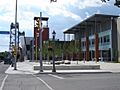
The Welland Civic Square
-
Welland's city crest
-
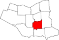
Location of Welland in the Niagara Region
