First Welland Canal facts for kids
The Welland Canal is a famous waterway in Ontario, Canada. It connects Lake Ontario and Lake Erie, allowing ships to travel around the huge Niagara Falls. Over time, five different versions of the canal have been built. The very first one, built between 1824 and 1833, is known as the First Welland Canal.
Contents
Before the Canal
The Great Lakes were like a superhighway for travel into the middle of North America. Ships could sail easily from Montreal all the way to Lake Superior. This made the lakes the best way to move people and goods across the continent.
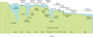
But there was a big problem: Niagara Falls! Ships couldn't get past them. So, people used a special road called a portage road. They would unload their cargo, carry it about 18 kilometers (11 miles) around the falls, and then load it onto different ships. This was a lot of hard work!
The Niagara Peninsula, a narrow strip of land between Lake Ontario and Lake Erie, seemed like a perfect spot for a canal. People thought about building one as early as 1799.
William Hamilton Merritt's Idea
In 1816, a young man named William Hamilton Merritt bought a sawmill on the Twelve Mile Creek. He also built a gristmill and a store. But the creek's water levels changed a lot, making it hard for his mills to work. In 1818, when the water was very low, Merritt thought about bringing water to his mills from the Welland River.
At the same time, the Erie Canal in the United States was almost finished. This canal would let cargo from the Great Lakes go to New York City, instead of Montreal. This was a big deal because Montreal and New York were rivals for trade. All these things made people realize how important a canal around Niagara Falls would be.
Planning the Route
In 1818, William Hamilton Merritt and some neighbors used a special tool called a water level to survey a possible canal route. They planned to connect the Twelve Mile Creek with the Welland River. They found a ridge that seemed 10 meters (33 feet) high, but it was actually twice that!
On July 4, 1818, Merritt held a meeting in St. Catharines. They decided to ask the government to build a canal that would also let boats cross the Niagara Escarpment. In 1823, an engineer named Hiram Tibbetts suggested a route. It would go from Port Robinson to Allanburg, then follow the Twelve Mile Creek to Port Dalhousie on Lake Ontario. For the steep part, he suggested an incline railway to move boats up and down.
Forming the Company
On January 19, 1824, the government created the Welland Canal Company. It had $150,000 to start, and Merritt was in charge of raising money. He traveled to the United States and Great Britain to find investors.
Later in 1824, they changed the canal route. Instead of an incline railway, they decided to use a series of canal locks to go down the escarpment in what is now Merritton. The canal would then join the Twelve Mile Creek and continue to Port Dalhousie. This new route made one of the original supporters, John DeCew, unhappy because it bypassed his property and took water from his mill.
Building the Canal
On November 30, 1824, about 200 people gathered near Allanburg for the official start of construction. The actual digging began in July 1825. Workers used natural waterways whenever they could. But for the section between Port Robinson and Allanburg, they had to dig a huge channel called the Deep Cut. This channel was over three kilometers (1.9 miles) long and sometimes 20 meters (66 feet) deep! They removed about 750,000 cubic meters (980,000 cubic yards) of earth.
As the canal was built, temporary towns called shantytowns grew up along the route to house the workers and their families. These shantytowns later became important communities like Port Dalhousie, Merritton, Thorold, Allanburg, and Port Robinson.
A New Path to Lake Erie
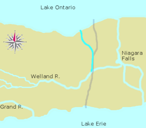
At first, the canal was meant to bring water to mills. But as it grew, it became clear it needed to be a ship route. The original plan was to follow the Welland River to the Niagara River. However, this was not ideal because the Niagara River had strong currents and was too close to the dangerous Niagara Falls.
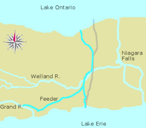
So, a second route was planned. It would branch off the canal at Port Robinson, follow Forks Creek, and then cut through Wainfleet to reach the Grand River and Lake Erie.
In September 1827, heavy rains stopped work on the Deep Cut. Many workers moved to the Wainfleet section. But the rains continued. On November 9, 1828, just two weeks before the Deep Cut was finished, the banks collapsed, killing some workers. More landslides followed. It became clear that they couldn't make the cut deep enough to use the Welland River as the main water source. They needed a higher source of water.
The Feeder Canal
Since the channel towards the Grand River was already being built, engineers suggested building a dam across the mouth of the Grand River in December 1828. From there, a new channel, called the Feeder Canal, could bring water to the main Welland Canal. An aqueduct (a bridge for water) would carry the canal over the Welland River.
The dam was moved inland by naval authorities to keep it safe. The town of Dunnville later grew up near this dam. The Feeder Canal went southeast to Stromness, then northeast across the Wainfleet Marsh. The aqueduct was built a few kilometers upstream from Port Robinson, where the canal would cross the Welland River.
Many workers from the Deep Cut moved to dig the Feeder Canal. They finished the digging in just 177 days, which was a huge achievement! Water from Lake Erie was let into the Feeder and Welland Canals in November 1829.
Like other places, shantytowns appeared along the Feeder Canal. These later became towns like Dunnville, Wainfleet, and Welland.
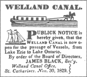
The Welland Canal officially opened on November 30, 1829, exactly five years after the first shovelful of earth was dug. Two ships, the Annie and Jane and the R.H. Broughton, sailed from Lake Ontario to Buffalo on Lake Erie in two days.
Reaching Lake Erie Directly
The route to Lake Erie through the Welland and Niagara Rivers was slow and difficult. The Feeder Canal connected directly to Lake Erie, but it was long and not big enough for large ships. By 1830, it was clear that a more direct route was needed.
In March 1831, a place called Gravelly Bay (now Port Colborne) was chosen as the new end point for the canal on Lake Erie. It was one of the closest spots on the lake and had a natural harbor for ships. The new part of the canal would be mostly straight, except for one section where it followed a ravine to avoid digging through hard rock.
The Welland Canal Company got a loan from the government. Construction started, but it was delayed by rain, difficulty clearing land, and a sickness outbreak in 1832. Digging through the Wainfleet Marsh and the rock was tough, but work sped up in late 1832 and early 1833.
On June 1, 1833, the ship Matilda became the first to travel through this new channel.
The First Canal is Complete
The combined Welland and Feeder Canals stretched about 44 kilometers (27 miles) between the two lakes. It had 40 wooden locks. Each lock was at least 33.5 meters (110 feet) long and 6.7 meters (22 feet) wide. The canal itself was at least 2.4 meters (8 feet) deep.
Today, very little of the original First Canal can be seen. However, much of the Feeder Canal still exists in the Wainfleet township.
 | George Robert Carruthers |
 | Patricia Bath |
 | Jan Ernst Matzeliger |
 | Alexander Miles |


