Welland River facts for kids
Quick facts for kids Welland River |
|
|---|---|

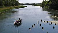
A boat on the river
|
|
| Other name(s) | Chippawa Creek |
| Country | Canada |
| Province | Ontario |
| Cities |
|
| Physical characteristics | |
| Main source | approx. 248 m (814 ft) 43°08′44″N 79°56′18″W / 43.14542°N 79.93847°W |
| River mouth | Niagara River 166 m (545 ft) 43°03′48″N 79°02′42″W / 43.06334°N 79.04504°W |
| Length | approx. 135–140 km (84–87 mi) |
| Width |
|
| Basin features | |
| Progression | Niagara River→ Lake Ontario→ Saint Lawrence River→ Gulf of Saint Lawrence |
The Welland River is a waterway in Southern Ontario, Canada. It flows through the cities of Welland and Niagara Falls. The river starts south of Hamilton, Ontario and ends when it joins the Niagara River. It was first known as the Chippawa Creek.
Contents
River History: How the Welland River Got Its Name
The Welland River was originally called the Chippawa Creek. This was because it flowed into the Niagara River near a place called Chippawa.
In 1792, the river was renamed by John Graves Simcoe. He was the first lieutenant governor of Upper Canada. This was an important leader of the government at the time. The new name, Welland, came from another river in Lincolnshire, England. Even today, some people in the Chippawa area still call it Chippawa Creek.
The famous Welland Canal was also named after this river. The first plan for the canal was to connect Lake Ontario to the Welland River. Later, the city of Welland got its name from both the river and the canal, as they both cross through the city.
O'Reilly's Bridge: A Historic Crossing
The oldest bridge over the Welland River was called O'Reilly's Bridge. It was built in 1901. This bridge connected the areas of Pelham and Wainfleet.
The story of the bridge began with a settler named Patrick O'Reilly. He moved to Wainfleet in 1806. Patrick fell in love with Sarah, who lived in Pelham. To make his trips shorter, he cut down two very tall trees and placed them across the river. After they got married, Sarah was scared to walk on the logs. So, a better bridge was built.
Over the years, O'Reilly's Bridge was improved many times. It became a unique single-lane iron bridge. This was the only one of its kind on the river. It was also one of the oldest iron bridges in Southern Ontario. In 2010, the old bridge was taken down. A new, wider bridge was built in its place.
River Geography: Where the Welland River Flows
The Welland River flows under two special water bridges called navigable aqueducts. These are part of the Welland Recreational Waterway and the new Welland Canal.
An important stream that flows into the Welland River is Coyle Creek. This creek is very beautiful, with many trees. It joins the river on its north side.
Near where the Welland River meets the Niagara River, a part of it branches off. This branch becomes a channel that helps create electricity. It flows through Niagara Falls to the Sir Adam Beck Hydroelectric Generating Stations in Queenston. The Welland River and its branches drain water from an area of about 880 square kilometers (340 square miles).
How the River Changes Direction
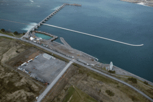
The International Control Dam is a special wall built in the Niagara River. This dam causes the Welland River to change its flow direction twice a day!
When less water flows over Niagara Falls at night, the water in the Niagara River rises. This causes the Welland River to flow backwards, sometimes as far as Wellandport. When more water is released over the falls, the Welland River changes direction again. It then flows normally towards the Niagara River.
|
 | Calvin Brent |
 | Walter T. Bailey |
 | Martha Cassell Thompson |
 | Alberta Jeannette Cassell |


