West Lincoln facts for kids
Quick facts for kids
West Lincoln
|
|
|---|---|
|
Township (lower-tier)
|
|
| Township of West Lincoln | |

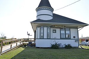
Train station in Smithville
|
|
| Motto(s):
Industry, Progress, Agriculture
|
|
| Country | |
| Province | |
| Region | Niagara |
| Area | |
| • Land | 387.81 km2 (149.73 sq mi) |
| Elevation | 181 m (594 ft) |
| Population
(2016)
|
|
| • Total | 14,500 |
| • Density | 37.4/km2 (97/sq mi) |
| Time zone | UTC-5 (EST) |
| • Summer (DST) | UTC-4 (EDT) |
| Postal Code |
L0R
|
| Area code(s) | 905, 289, 365, and 742 |
| Website | www.westlincoln.ca |
West Lincoln is a township in the Niagara Region of Ontario, Canada. A township is like a group of smaller towns and villages working together. The main parts of West Lincoln are found along what used to be Highway 20. The main office for West Lincoln is in Smithville. Smithville is located right between Hamilton and Pelham.
Exploring West Lincoln's Communities
West Lincoln is made up of many different communities. These include places like Abingdon, Allens Corner, Attercliffe, and Basingstoke. You can also find Bismark, Boyle, Caistor Centre, and Caistorville here. Other communities are Elcho, Fulton, Grassie, Kimbo, and Port Davidson. Don't forget Rosedene, Silverdale, Smithville, St. Anns, Vaughan, Warner, Wellandport, Wilcox Corners, and Winslow! Each one adds something special to the township.
Local Businesses and Fun
In Smithville, which is the heart of West Lincoln, you'll find places to shop. There's a downtown area and also the Village Square Mall. These are the two main spots for stores.
Smithville also has a cool Farmers Market. It happens every Friday afternoon during the summer. At the market, you can find lots of local goodies. Vendors sell fresh produce, homemade preserves, meat, honey, flowers, and delicious baked goods. It's a great place to find local treats!
Who Lives in West Lincoln?
| Historical population | ||
|---|---|---|
| Year | Pop. | ±% |
| 1991 | 10,864 | — |
| 1996 | 11,513 | +6.0% |
| 2001 | 12,268 | +6.6% |
| 2006 | 13,167 | +7.3% |
| 2011 | 13,837 | +5.1% |
| 2016 | 14,500 | +4.8% |
In 2021, Statistics Canada counted the people living in West Lincoln. There were 15,454 people living here. This was a jump from 14,500 people in 2016. West Lincoln covers about 387 square kilometers (about 149 square miles) of land. This means that in 2021, there were about 40 people living in each square kilometer.
 | James B. Knighten |
 | Azellia White |
 | Willa Brown |


