Port Colborne facts for kids
Quick facts for kids
Port Colborne
|
||
|---|---|---|
| City of Port Colborne | ||
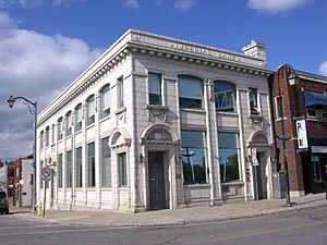
Former bank building on West Street in Port Colborne
|
||
|
||
| Motto(s):
"Gateway to Navigation"
|
||
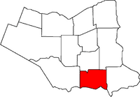
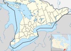
Location of Port Colborne in the Niagara Region
|
||
| Country | Canada | |
| Province | Ontario | |
| Region | Niagara | |
| Settled | 1830s | |
| Incorporated | 1870 (village) | |
| 1966 (city) | ||
| Area | ||
| • Land | 121.96 km2 (47.09 sq mi) | |
| Elevation | 175.30 m (575.13 ft) | |
| Population
(2021)
|
||
| • Total | 20,033 | |
| • Density | 164.2/km2 (425/sq mi) | |
| Demonym(s) | Port Colbornite | |
| Time zone | UTC-5 (EST) | |
| • Summer (DST) | UTC-4 (EDT) | |
| Forward Sortation Area |
L3K
|
|
| Area code(s) | 905, 289, 365, and 742 | |
| GNBC Code | FCHYP | |
Port Colborne is a city in Ontario, Canada. It is located on the shores of Lake Erie. The city is at the southern end of the Welland Canal. This area is part of the Niagara Region in Southern Ontario.
The first settlement here was called Gravelly Bay in 1832. It was later renamed after Sir John Colborne. He was a British war hero and a leader in Upper Canada. This happened when the Welland Canal opened its southern end in 1833. In 2021, about 20,033 people lived in Port Colborne.
Contents
History of Port Colborne
Before European settlers arrived, Indigenous peoples called the Onguiaahra (Neutral Iroquois) lived in this area. They used the local flint and chert for tools. When European traders brought firearms, the Six Nations of the Iroquois pushed them out around 1650. This was part of conflicts known as the Beaver Wars.
The city we know today as Port Colborne started as Gravelly Bay. It was named after the shallow, rocky bay it sits on. After the American Revolution, families loyal to Britain, called United Empire Loyalists, settled here. The town grew quickly after the Welland Canal reached Lake Erie in 1833. In 1919, there was a grain elevator explosion in Port Colborne. It sadly killed 10 people and injured 16.
As more people moved in, Welland County was created in 1845. Port Colborne became a village in 1870 and a town in 1918. It joined with the nearby Village of Humberstone in 1952. Then, in 1966, it officially became a city. In 1970, the city grew even more when Humberstone Township was added.
In 1888, American tourists from the Southern states began building summer homes here. By 1890, a whole gated community of vacationers from the US South called Port Colborne their summer home. They named it The Humberstone Club. Many large summer homes were built along the lake, and some still stand today on Tennessee Avenue. Their Southern style influenced other buildings in the area. During the American Civil War, Varina Davis, the wife of Confederacy President Jefferson Davis, lived safely in this community for three years.
Port Colborne was greatly affected by the Blizzard of 1977. Thousands of people were stuck when the city was shut down by the storm. This event is still a big memory for the local people.
Environmental Cleanup Efforts
A metal refinery, run by a company called Inco (now Vale), closed in 1984. Emissions from the refinery had left some soil with high levels of nickel, copper, and cobalt. These levels were above the safety limits set by the Ontario Ministry of the Environment.
However, studies in 1997 and 1999 found no clear health problems caused by these environmental exposures. After meetings with the city and the Ministry of the Environment, a plan was made. They decided to assess the risk to residents and figure out what Inco needed to do to clean up the affected areas.
Some residents later filed a lawsuit against Inco. They were seeking money for property value loss. In 2010, the Ontario Supreme Court ruled in favor of the residents. They awarded money to over 7,000 households in Port Colborne. However, after appeals, the Supreme Court of Canada later sided with Vale in 2012. This meant the residents did not receive the awarded money.
Geography and Climate
Port Colborne's Climate
| Climate data for Port Colborne (1981−2010) | |||||||||||||
|---|---|---|---|---|---|---|---|---|---|---|---|---|---|
| Month | Jan | Feb | Mar | Apr | May | Jun | Jul | Aug | Sep | Oct | Nov | Dec | Year |
| Record high °C (°F) | 15.0 (59.0) |
16.0 (60.8) |
24.0 (75.2) |
32.5 (90.5) |
31.5 (88.7) |
33.5 (92.3) |
35.0 (95.0) |
33.0 (91.4) |
31.0 (87.8) |
27.2 (81.0) |
20.0 (68.0) |
18.0 (64.4) |
35.0 (95.0) |
| Mean daily maximum °C (°F) | −0.4 (31.3) |
0.6 (33.1) |
4.8 (40.6) |
11.5 (52.7) |
17.9 (64.2) |
23.1 (73.6) |
25.9 (78.6) |
25.4 (77.7) |
21.3 (70.3) |
14.8 (58.6) |
8.7 (47.7) |
2.7 (36.9) |
13.0 (55.4) |
| Daily mean °C (°F) | −3.7 (25.3) |
−2.9 (26.8) |
0.8 (33.4) |
7.0 (44.6) |
13.2 (55.8) |
18.7 (65.7) |
21.9 (71.4) |
21.3 (70.3) |
17.4 (63.3) |
11.0 (51.8) |
5.5 (41.9) |
−0.4 (31.3) |
9.2 (48.6) |
| Mean daily minimum °C (°F) | −6.9 (19.6) |
−6.5 (20.3) |
−3.2 (26.2) |
2.4 (36.3) |
8.5 (47.3) |
14.4 (57.9) |
17.8 (64.0) |
17.2 (63.0) |
13.4 (56.1) |
7.3 (45.1) |
2.2 (36.0) |
−3.4 (25.9) |
5.3 (41.5) |
| Record low °C (°F) | −26 (−15) |
−25 (−13) |
−24 (−11) |
−11.5 (11.3) |
−3.5 (25.7) |
2.2 (36.0) |
6.0 (42.8) |
5.0 (41.0) |
−0.5 (31.1) |
−6.1 (21.0) |
−11.5 (11.3) |
−26 (−15) |
−26 (−15) |
| Average precipitation mm (inches) | 73.1 (2.88) |
57.0 (2.24) |
66.8 (2.63) |
76.1 (3.00) |
89.7 (3.53) |
78.9 (3.11) |
82.2 (3.24) |
82.5 (3.25) |
98.0 (3.86) |
90.4 (3.56) |
100.9 (3.97) |
88.8 (3.50) |
984.6 (38.76) |
| Average rainfall mm (inches) | 32.5 (1.28) |
26.9 (1.06) |
46.6 (1.83) |
71.9 (2.83) |
89.1 (3.51) |
78.9 (3.11) |
82.2 (3.24) |
82.5 (3.25) |
98.0 (3.86) |
89.7 (3.53) |
95.2 (3.75) |
53.2 (2.09) |
846.8 (33.34) |
| Average snowfall cm (inches) | 40.5 (15.9) |
30.1 (11.9) |
20.2 (8.0) |
4.2 (1.7) |
0.6 (0.2) |
0.0 (0.0) |
0.0 (0.0) |
0.0 (0.0) |
0.0 (0.0) |
0.8 (0.3) |
5.8 (2.3) |
35.6 (14.0) |
137.7 (54.2) |
| Average precipitation days (≥ 0.2 mm) | 15.2 | 11.1 | 12.5 | 13.8 | 13.3 | 11.2 | 10.6 | 10.3 | 11.8 | 13.4 | 15.1 | 14.9 | 153.2 |
| Average rainy days (≥ 0.2 mm) | 6.2 | 5.3 | 8.7 | 13.2 | 13.3 | 11.2 | 10.6 | 10.3 | 11.8 | 13.4 | 13.9 | 9.0 | 127.1 |
| Average snowy days (≥ 0.2 cm) | 9.6 | 6.6 | 4.5 | 1.4 | 0.08 | 0.0 | 0.0 | 0.0 | 0.0 | 0.12 | 1.9 | 7.1 | 31.3 |
| Source: Environment Canada. | |||||||||||||
Local Communities
The city of Port Colborne includes several smaller communities:
- Bethel - near Chippawa Road and Yager Road
- Cedar Bay - near Cedar Bay Road and Vimy Road
- East Village
- Elco Beach - near Wyldewood Road and Fireland 15
- Gasline - near Pinecrest Road and Vimy Road
- Humberstone - near Killaly Street and Highway 3
- Lorraine - near Weaver Road and Firelane 1
- Nickel Beach - at the end of Lake Road
- Pine Crest Point - near Pincrest Road and Firelane 2
- Pleasant Beach
- Sherkston
- Sherkston Beaches
- Shisler Point
- Silver Bay
- Sugar Loaf Point/Sugar Loaf Marina - on the west side of Gravelly Bay
Population Information
| Port Colborne | ||
|---|---|---|
| Year | Pop. | ±% |
| 1871 | 1,500 | — |
| 1901 | 1,253 | −16.5% |
| 1911 | 1,624 | +29.6% |
| 1921 | 3,415 | +110.3% |
| 1931 | 6,503 | +90.4% |
| 1941 | 6,928 | +6.5% |
| 1951 | 8,275 | +19.4% |
| 1961 | 14,886 | +79.9% |
| 1971 | 21,420 | +43.9% |
| 1981 | 19,225 | −10.2% |
| 1991 | 18,766 | −2.4% |
| 2001 | 18,450 | −1.7% |
| 2006 | 18,599 | +0.8% |
| 2011 | 18,424 | −0.9% |
| 2016 | 18,306 | −0.6% |
| 2021 | 20,033 | +9.4% |
In the 2021 Census, Port Colborne had a population of 20,033 people. This was a 9.4% increase from its 2016 population of 18,306. The city has a land area of about 122 square kilometers. This means there were about 164 people per square kilometer in 2021.
| Canada census – Port Colborne community profile | |||
|---|---|---|---|
| 2016 | 2011 | 2006 | |
| Population: | 18,306 (-0.6% from 2011) | 18,424 (-0.9% from 2006) | 18,599 (+0.8% from 2001) |
| Land area: | 121.96 km2 (47.09 sq mi) | 121.97 km2 (47.09 sq mi) | 121.97 km2 (47.09 sq mi) |
| Population density: | 150.1/km2 (389/sq mi) | 151.1/km2 (391/sq mi) | 152.5/km2 (395/sq mi) |
| Median age: | 50.0 (M: 48.8, F: 51.1) | 47.5 (M: 46.4, F: 48.6) | 44.9 (M: 43.5, F: 46.1) |
| Total private dwellings: | 9,825 | 10,083 | 8,519 |
| Median household income: | $57,244 | $49,404 | |
| References: 2016 2011 2006 earlier | |||
Economy and Jobs
Shipping and trade have always been important to Port Colborne's economy. This includes providing supplies to workers on the canal and repairing ships. For much of the early 1900s, Port Colborne was a busy industrial city. Major employers included a grain elevator, flour mills, a Vale nickel refinery, a cement plant, and a blast furnace for steel.
Recently, Port Colborne has attracted new businesses. For example, Casco Inc. and Jungbunzlauer process corn into products like sweeteners and citric acid.
The International Nickel Company (now Vale) has been a main employer since its refinery opened in 1918. They used cheap hydroelectricity from nearby Niagara Falls. The refinery made nickel for the war effort. By the 1950s, over 2,000 people worked there. Today, with fewer operations and more machines, about 170 people work at the refinery.
Marine Recycling Corporation is a company that recycles ships. They focus on environmentally friendly methods. It is located next to the Welland Canal at Gravelly Bay and has been operating since the 1970s.
Here are some of the largest private employers in Port Colborne as of 2012 (with over 50 staff):
- Port Colborne Poultry (Pinty's Delicious Foods, now Olymel), 229 employees
- Vale Canada Limited, 200 employees
- J. Oskam Steel Fabricators Ltd., 150 employees
- IMT Partnership, 108 employees
- ADM Milling, 95 employees
- Thurston Machine Co. Ltd., 85 employees
- JTL Machine Ltd., 78 employees
- Jungbunzlauer Canada Inc., 74 employees
- Brennan Paving Ltd., 70 employees
- Ingredion Canada Inc., 70 employees
Arts and Culture
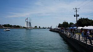
Port Colborne holds the yearly Canal Days festival. This festival celebrates the important role of the Welland Canal in the city's history. It started as a small fair at the Port Colborne Historical and Marine Museum. Now, it features live music, an antique car show, fireworks, tall ships, and international foods.
The festival also highlights Lock 8, which is one of the world's longest canal locks at 420 meters (1,378 feet). Lock 8 helps keep the water level in the Welland Canal steady. This means ships are only raised or lowered a small amount, depending on the water level in Lake Erie. Much of the festival takes place along West St., which runs next to the canal. From here, you can see the Clarence St. Bridge, a lift bridge built in 1929.
The Port Colborne Historical and Marine Museum is in the center of town. It is a great place to learn about local history. It has old buildings and artifacts. It also has a research area for studying local history.
The community has two theater groups: the professional Lighthouse Festival Theatre and the amateur Port Colborne Operatic Society. The Operatic Society has been putting on shows every year since 1945.
The Port Colborne Lions Club started in 1922. It is one of the oldest Lions Clubs in the world. It is also one of Canada's oldest service clubs that has been running continuously. The club is still active and hosts many events, like an annual carnival in the summer.
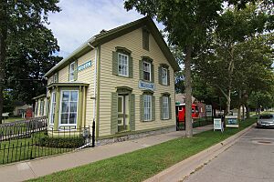
Kinnear House is a historic building linked to Helen Kinnear. She was the first woman in Canada to be appointed as a judge by the federal government. She was also the first woman to argue a case before the Supreme Court of Canada.
There's a fun optical illusion in Port Colborne called the "incredible shrinking mill." When you drive east on Lakeshore Road, the federal grain elevator seems to move farther away as you get closer to it!
Attractions and Things to Do

Tourism is a big part of Port Colborne's economy. This is because of its beautiful Lake Erie beaches, marinas, and its closeness to Niagara Falls. In 2015, the city created a committee to help bring more tourists to the area. Port Colborne is known as "Niagara's South Coast." It offers live theater, golf, trails, fishing, beaches, restaurants, and shopping areas along the Welland Canal.
Some popular places to visit in Port Colborne include:
- The Welland Canal
- Port Colborne Port Promenade
- The Friendship Trail
- HH Knoll Lakeview Park
- The Welland Canals Parkways Trail
- Nickel Beach
- Lock 8 Gateway Park
- Sugarloaf Harbour Marina
- Historical and Marine Museum
- Vale Centre (a sports complex with an arena, YMCA pool, gyms, and bocce courts)
- Thomas A. Lannan Sports Complex
Education in Port Colborne
Port Colborne has two high schools:
- Port Colborne High School (often called Port High)
- Lakeshore Catholic High School (which used to be a public high school called Lockview Park Secondary School, but it closed in 1987)
Notable People from Port Colborne
Many interesting people have come from Port Colborne, including:
- David Lametti, a federal Minister of Justice
- Tony Dekker, a singer/songwriter from the folk band Great Lake Swimmers
- Jim Gregory, a former NHL General Manager for the Toronto Maple Leafs
- Ted 'Teeder' Kennedy, a famous NHL hockey player
- Helen Kinnear, the first woman appointed as a judge by the federal government
- Joseph "Bronco" Horvath, an NHL hockey player
- Melissa McIntyre, an actress known for Degrassi: The Next Generation
- Don Simmons, an NHL hockey player
- Lynton 'Red' Wilson, former CEO of BCE Inc., chancellor of McMaster University, and an officer of the Order of Canada
- DeFranco Family, a pop music group from the 1970s
- Francis William "Dinty" Moore, a goaltender for the 1936 Canadian men's Olympic hockey team
- Lieutenant Colonel Russell Lambert Boyle, a commanding officer who died in World War I
- Alexis Davis, a mixed martial artist
- Elmer Iseler, a choral conductor
- Matt Craven, an actor
- Vance Badawey, a politician
- Bill McBirnie, an award-winning jazz flautist
See also
 In Spanish: Port Colborne para niños
 | James Van Der Zee |
 | Alma Thomas |
 | Ellis Wilson |
 | Margaret Taylor-Burroughs |


