
Hereford Mappa Mundi facts for kids
The Hereford Mappa Mundi is a very old map of the world, made around the year 1300. It's called a "mappa mundi," which is Latin for "map of the world." This map is special because it's the largest medieval map still existing today. You can see it at Hereford Cathedral in Hereford, England. Another huge map, the Ebstorf map, was sadly destroyed in 1943 during a war, but we still have photos of it.
For many years, the Hereford Mappa Mundi just hung on a wall in the cathedral, not getting much attention. During a time called the Commonwealth of England, the map was hidden under the floor of a chapel to keep it safe. In 1855, it was cleaned and fixed up at the British Museum. Later, during the Second World War, the map and other valuable old books were moved to a safe place. They were brought back to the cathedral in 1946.
In 1988, there was a money problem at the cathedral. Some people suggested selling the map to raise funds. This caused a big debate! Luckily, many people and groups, like the National Heritage Memorial Fund and Paul Getty, gave large donations. These gifts helped keep the map in Hereford. They also allowed a new library to be built to properly house the map and other old books. This new library opened in 1996. You can even see a high-quality digital version of the map online, with over 1,000 notes about places and names.
Contents
What the Map Shows
The Hereford Mappa Mundi is drawn on a single piece of vellum, which is a type of animal skin. It measures about 158 centimeters (about 5 feet) tall and 133 centimeters (about 4.4 feet) wide. This makes it the biggest medieval map we still have! The map uses black ink for most of the writing. It also has red and gold details, and blue or green colors for water. The Red Sea is even painted red!
This amazing map shows many things:
- 420 towns
- 15 stories from the Bible
- 33 animals and plants
- 32 people
- 5 scenes from old myths
At the very center of the map, you'll find Jerusalem. The map is drawn with east at the top. This means the Garden of Eden is shown in a circle at the very edge of the world, at the top. Great Britain is drawn at the bottom left, on the northwestern edge. Interestingly, the labels for Africa and Europe are swapped! Europe is written as "Africa" in red and gold, and vice versa.
The map is based on older stories and maps, not on the actual geography known in the 1300s. For example, the Caspian Sea is shown connected to the ocean around the world. But explorers like William of Rubruck had already reported in 1255 that it was a landlocked sea.
The map's circular shape, often called a "T and O" map, doesn't mean people thought the Earth was flat. People in the Middle Ages knew the Earth was round. The circular shape was just a common way to draw the known parts of the world. They believed only the Northern Hemisphere was where humans lived.
This map is also the first known map to show the mythical Saint Brendan's Island. This island then appeared on many other maps made later, like Martin Behaim's Erdapfel globe from 1492.
Who Made the Map?
The map is signed by, or thought to be made by, someone named "Richard of Haldingham and Lafford." He was also known as Richard de Bello. However, some people don't fully agree that one person could have created such a detailed map. They think that Richard of Haldingham and Lafford might have started it. Then, after he died, his younger cousin, Richard de Bello, might have finished it with his helper, Richard Swindfield.
For a long time, people believed the map was made in Lincoln, not Hereford. This is because the city of Lincoln is drawn with a lot of detail. It even shows its cathedral accurately placed on a hill near a river. Hereford, on the other hand, is only shown as a cathedral, and it looks like it was added later by a different artist. However, new studies on the wood used for the map's frame suggest it might have been made in or near Hereford after all.
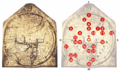
Important Places on the Map
Here are some of the places you can find on the Hereford Mappa Mundi:
- 0 – At the center: Jerusalem, with a cross above it.
- 1 – Paradise, surrounded by a wall and fire.
- 2 – The Ganges River and its delta.
- 3 – The amazing island of Taphana, possibly Sri Lanka or Sumatra.
- 4 – The Indus River and Tigris River.
- 5 – The Caspian Sea, and the land of Gog and Magog.
- 6 – Babylon and the Euphrates River.
- 7 – The Persian Gulf.
- 8 – The Red Sea (painted red!).
- 9 – Noah's Ark.
- 10 – The Dead Sea, Sodom and Gomorrah, and the Jordan River. Above it, Lot's wife.
- 11 – Egypt with the Nile River.
- 12 – The Nile River again, or maybe a hint at the ocean around the equator. Far outside, a land of strange, mythical people.
- 13 – The Sea of Azov with the Don and Dnieper River. Above it, the Golden Fleece.
- 14 – Constantinople; to its left, the Danube River's delta.
- 15 – The Aegean Sea.
- 16 – A very large delta of the Nile with Alexandria's Pharos lighthouse.
- 17 – The legendary Norwegian skier, Gansmir, with his skis.
- 18 – Greece with Mount Olympus, Athens, and Corinth.
- 19 – Crete (in the wrong place) with the Minotaur's circular labyrinth.
- 20 – The Adriatic Sea; Italy with Rome. A famous Latin saying about Rome is written here: "Rome, the head of the world, holds the reins of the round globe."
- 21 – Sicily and Carthage, which was Rome's enemy.
- 22 – Scotland.
- 23 – England.
- 24 – Ireland.
- 25 – The Balearic Islands.
- 26 – The Strait of Gibraltar (also known as the Pillars of Hercules).
In Books
The Hereford Mappa Mundi is an important part of the story in the 2007 novel Resistance by Owen Sheers.
Images for kids
-
Locations on the Hereford mappa mundi
-
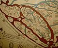
A closer look at the British Isles
-
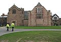
The new library at Hereford Cathedral (right) where the map is now housed


See also
 In Spanish: Mapamundi de Hereford para niños
