
Aegean Sea facts for kids
Quick facts for kids Aegean Sea |
|
|---|---|

A Topographical and bathymetric map of the Aegean Sea
|
|
| Location | Mediterranean Sea |
| Coordinates | 39°N 25°E / 39°N 25°E |
| Type | Sea |
| Etymology | From Aegeus |
| Primary inflows | Inachos, Ilisos, Spercheios, Pineios, Haliacmon, Vardar, Struma, Nestos, Maritsa |
| Primary outflows | Mediterranean Sea |
| Basin countries | Greece, Turkey; North Macedonia, Serbia, Bulgaria (drainage basins for inflow rivers) |
| Max. length | 700 km (430 mi) |
| Max. width | 400 km (250 mi) |
| Surface area | 214,000 km2 (83,000 sq mi) |
| Max. depth | 3,544 m (11,627 feet) |
| Islands | 150+ |
| Settlements | Alexandroupoli, Athens, Ayvalık, Bodrum, Çanakkale, Çeşme, Didim, Heraklion, İzmir, Kavala, Kuşadası, Thessaloniki, Volos |

The Aegean Sea is a part of the Mediterranean Sea. It's located between Greece and Turkey. It covers about 215,000 square kilometers.
In the north, it connects to the Sea of Marmara and the Black Sea. This connection happens through narrow waterways. These waterways are called the Dardanelles and Bosphorus. Many Aegean Islands are found in this sea. Big islands like Crete and Rhodes are in the south. The deepest part of the Aegean Sea is about 3,544 meters (11,627 feet) deep. This deep area is located east of Crete.
The Aegean Sea has many island groups. These include the Dodecanese, the Cyclades, and the Sporades. Other groups are the Saronic Islands and the North Aegean islands. Crete and its nearby islands are also part of this area. The Dodecanese islands are in the southeast. They include Rhodes, Kos, and Patmos. Delos and Naxos are in the Cyclades, which are in the south. Lesbos is one of the North Aegean Islands. Euboea, the second largest island in Greece, is also in the Aegean Sea.
Many parts of Greece border the Aegean Sea. Several Turkish provinces also border it to the east. These include Edirne, Çanakkale, Balıkesir, İzmir, Aydın, and Muğla Province. Some Turkish islands in the sea are Imbros, Tenedos, Cunda Island, and the Foça Islands.
The Aegean Sea has a very important history. It was especially key for Ancient Greece. People from Ancient Greece lived all around its coasts and on its islands. The islands made it easy for people to travel and trade. They connected people from different areas. They also linked Europe and Asia. Besides Greeks, Thracians lived along the northern coast.
Later, the Roman Empire took control of the area. After that, the Byzantine Empire ruled it. The Fourth Crusade weakened the Byzantine Empire's power. Eventually, the Ottoman Empire conquered most of the area. However, Crete remained a Venetian colony until 1669. The Greek War of Independence led to a Greek state in 1829. The Ottoman Empire controlled the sea for over 500 years. After its breakup, modern Turkey took its place.
The sea was once called the Archipelago. In Ancient Greek, this meant "chief sea." But now, archipelago means any group of islands. The rocks on the seabed are mostly limestone. However, they have been changed by volcanoes. Volcanic activity has happened in this area recently. The colorful sediments near Santorini and Milos islands are very interesting. These islands are in the southern Aegean.
Important cities along the Aegean coast include Athens, Thessaloniki, Volos, Kavala, and Heraklion in Greece. In Turkey, major cities are İzmir and Bodrum.
Greece and Turkey have some disagreements about the Aegean Sea. These disagreements are about things like territorial waters. They also concern national airspace and economic zones. These issues have affected how Greece and Turkey get along since the 1970s.
History of the Aegean Sea

Long ago, two main groups lived near the Aegean Sea. These were the Minoans from Crete and the Mycenaeans from the Peloponnese. Later, the famous city-states of Athens and Sparta became powerful. These were part of Ancient Greece.
Over time, many other empires and groups came to the Aegean Sea. These included the Persians, Romans, the Byzantine Empire, and people from Venice. The Seljuk Empire and the Ottoman Empire also had a presence here. The people living near the Aegean were very advanced in Ancient history. They used the sea to travel and communicate with each other.
There are seven main groups of islands in the Aegean Sea. These are the Thracian Sea group, the East Aegean group, and the Northern Sporades. Also, there are the Cyclades, the Saronic Islands, the Dodecanese, and Crete. The word archipelago used to refer specifically to these islands.
Many Aegean islands are actually parts of mountain ranges. These mountains extend from the mainland into the sea. For example, one chain goes towards Chios. Another goes across Euboea to Samos. A third chain crosses the Peloponnese and Crete to Rhodes. This last chain helps separate the Aegean Sea from the wider Mediterranean Sea.
Many islands have safe harbors and bays. However, sailing in the Aegean can be tricky. Some islands are volcanos. Others have valuable minerals like marble and iron. The larger islands often have green valleys and plains. Two big islands in the Aegean Sea belong to Turkey: Bozcaada and Gökçeada.
Images for kids
-
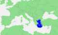
The extent of the Aegean Sea on a map of the Mediterranean Sea
-

A view of Thessaloniki, a major city in Greece
-
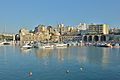
The old Venetian Arsenals in Heraklion, Crete
-
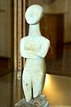
A female figure from Naxos (2800-2300 BC)
-
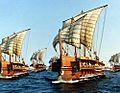
A fleet of Athenian triremes, ancient Greek warships
-
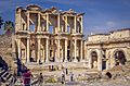
The Library of Celsus, a Roman building in the ancient port city of Ephesus
-

German Tanks in Rhodes during World War II


,_143205.jpg)


See also
 In Spanish: Mar Egeo para niños
