
Santorini facts for kids
Quick facts for kids
Santorini
Σαντορίνη
Θήρα |
|
|---|---|
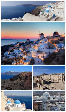 Clockwise from top: Partial panoramic view of Santorini, sunset in the village of Oia, ruins of the Stoa Basilica at Ancient Thera, the Orthodox Metropolitan Cathedral of Ypapanti (it) Cattedrale della Presentazione di Cristo (Fira) at the town of Fira, the Aegean Sea as seen from Oia, and view of Fira from the island of Nea Kameni at the Santorini caldera.
|
|

Santorini
Location in Greece
|
|
| Country | Greece |
| Administrative region | South Aegean |
| Regional unit | Thira |
| Area | |
| • Municipality | 90.69 km2 (35.02 sq mi) |
| Population
(2021)
|
|
| • Municipality | 15,480 |
| • Municipality density | 170.69/km2 (442.09/sq mi) |
| • Municipal unit | 14,393 |
| Community | |
| • Population | 1,516 (2021) |
| Time zone | UTC+2 (EET) |
| • Summer (DST) | UTC+3 (EEST) |
| Postal code |
847 00, 847 02
|
| Area code(s) | 22860 |
| Vehicle registration | EM |

Santorini (Greek: Σαντορίνη, romanized: Santoríni), also officially known as Thira (Greek: Θήρα, romanized: Thíra), is a beautiful Greek island. It's located in the southern Aegean Sea, about 200 kilometers (124 miles) southeast of mainland Greece. Santorini is the largest island in a small group of circular islands. These islands were formed by the Santorini caldera, which is a large volcanic crater.
Santorini is the southernmost island in the Cyclades group. It covers about 73 square kilometers (28 square miles) and had a population of 15,480 people in 2021. The municipality of Santorini includes other islands like Therasia, Nea Kameni, Palaia Kameni, Aspronisi, and Christiana. The total land area is about 90.623 square kilometers (35 square miles).
This island was once the site of one of the biggest volcanic eruptions ever recorded. This event, called the Minoan eruption, happened about 3,600 years ago. It took place during the time of the Minoan civilization. The eruption created the large caldera you see today. It also left behind thick layers of volcanic ash, hundreds of meters deep.
Santorini is the most active volcano in the South Aegean Volcanic Arc. Today, the main part of the volcano is a caldera filled with water. This volcanic area is about 500 kilometers (310 miles) long. Volcanic activity on Thera started around 2 million years ago.
Contents
What's in a Name?
Santorini got its name from the Latin Empire in the 13th century. It refers to Saint Irene, named after an old church in the village of Perissa. The name Santorini is a shorter version of "Santa Irini."
Before this, the island had other names. It was called Kallístē (meaning "the most beautiful one") or Strongýlē (meaning "the circular one"). The ancient name Thera was used after Theras, a Spartan leader who settled the island. This old name was brought back in the 19th century as the island's official name. However, most people still call it Santorini.
A Look Back in Time
Ancient Akrotiri: A Buried City


Since 1967, archaeologists have been digging at a place called Akrotiri. This site has shown us a lot about the Minoan civilization outside of Crete. At that time, the island wasn't called Thera.
Only a small part of a large town has been found so far. But it shows buildings with many levels, streets, and squares. Some walls still stand as high as eight meters! All of this was buried by the ash from the famous volcanic eruption. Akrotiri wasn't a palace like those on Crete. It was a complex community with amazing stonework and beautiful wall paintings. A workshop for looms suggests they made textiles for trade. This Bronze Age civilization was very successful between 3000 and 2000 BC. It reached its peak from 2000 to 1630 BC.
Many houses in Akrotiri were big, some even three stories tall. Their streets, squares, and walls were kept safe by the layers of volcanic ash. Some stone staircases are still in place. They also found huge ceramic storage jars (called pithoi), mills, and pottery.
The most famous finds are the wall paintings, or frescoes. They kept their original colors because they were buried under meters of volcanic ash. These artworks show that the people of Akrotiri were skilled and quite wealthy. Some frescoes show two antelopes, a man holding fish, and boats with dolphins. Others show women sitting under canopies. There's also a famous fresco of "Saffron-gatherers" offering crocus flowers to a seated woman, who might have been a goddess.
The town also had a very advanced drainage system. Pipes with running water and water closets found at Akrotiri are the oldest ever discovered! The pipes had two systems, meaning they used both hot and cold water. The hot water probably came from the volcano's heat.
The well-preserved ruins of Akrotiri are often compared to Pompeii in Italy. The site was closed for almost seven years after a canopy collapsed in 2005. It reopened in April 2012.
The earliest signs of people living here are from the Late Neolithic period (around 4000 BC or earlier). But around 2000–1650 BC, Akrotiri became a major Bronze Age port in the Aegean Sea. Objects found there came from places like Crete, Anatolia, Cyprus, Syria, and Egypt.
When Did the Big Eruption Happen?


The Minoan eruption is a very important event for figuring out the timeline of the second millennium BC in the Aegean. This is because signs of the eruption are found all over the region.
Archaeologists first thought the eruption happened around 1500 BC. But radiocarbon dating (a scientific way to date old things) suggests it happened between 1645–1600 BC. Tree ring data also points to 1628 BC. Because of these differences, scientists are still working to pinpoint the exact date.
Life in Ancient Times
After the Bronze Age, Phoenicians settled on Thera. The historian Herodotus wrote that they called the island Callista. Later, in the 9th century BC, a group called the Dorians built a main Greek city on Mesa Vouno mountain. They named the city and the island after their leader, Theras. Today, this city is known as Ancient Thera.
In ancient Greek stories, the island of Thera was said to be given by the sea god Triton to a Greek hero named Euphemus. The story says Euphemus threw a clod of dirt into the sea, and it grew into an island for his descendants. The island was later named Thera after Euphemus's descendant, Theras.
In the 5th century BC, Thera sided with Sparta against Athens during the Peloponnesian War. Later, during the Hellenistic period, the island became an important naval base for Ptolemaic Egypt.
Medieval and Ottoman Rule

Like other Greek lands, Thera was ruled by the Romans. When the Roman Empire split, the island became part of the Byzantine Empire. The volcano erupted again in 727 AD. This scary event was seen as a sign from above.
The name "Santorini" first appeared around 1153–1154. After the Fourth Crusade, the island was taken over by the Duchy of Naxos. Later, it was controlled by Venetian families. Because of the Venetians, Santorini became home to many Catholic people. It still has a Catholic bishopric today.
From the 15th century, the Ottoman Empire recognized Venice's control over the island. However, Ottoman raids continued until they finally captured Santorini in 1576. Santorini kept some special rights in the 17th century. It was briefly captured by the Russians in 1768–1774 but returned to Ottoman control.
The 19th Century and Independence
In the early 1800s, Santorini was an important shipping center. Many islanders were farmers and sailors who traded their goods, especially wine. Education also improved, with monasteries becoming important learning centers.
In 1821, Greece began its fight for independence from the Ottoman Empire. Santorini played a role, sending sailors and supplies to the Greek fleet. The island faced challenges, including disagreements over taxes and leadership. However, it eventually became part of the new Greek state.
Santorini officially became part of the independent Kingdom of Greece in 1832. The island also joined a revolt against King Otto of Greece in 1862, which led to his overthrow.
World War II and After
During World War II, Italian forces occupied Santorini in 1941. Then, the Germans took over in 1943. In 1944, British commandos raided the German base on Santorini. Sadly, five local people, including the mayor, were shot in revenge.
After the war, Santorini's economy faced difficulties. Many factories closed, and people moved to Athens for work. To help the island, the Union of Santorini Cooperatives was formed in 1947. They worked to process and sell the island's farm products, especially its wine.
In the early 1950s, tourism began to grow. Wealthy visitors came on yacht cruises. The island's children would welcome them with flowers. A shipping owner named Evangelos P. Nomikos and his wife helped build the Hotel Atlantis in 1952. It became the most luxurious hotel in the Cyclades.
In 1954, Santorini had about 12,000 people and few tourists. The only ways to get around were by jeep, a small bus, or traditional donkeys and mules.
The 1956 Earthquake
On July 9, 1956, a powerful earthquake struck near Santorini. It was one of the largest earthquakes in Greece in the 20th century. It caused huge damage to Santorini. An aftershock, 13 minutes later, caused most of the destruction and injuries. A tsunami also hit the island, with waves up to 3 meters (10 feet) high in some areas.
The Greek Prime Minister visited the island to see the damage. Many countries offered help. The Greek military dropped food, tents, and supplies from the air. Camps were set up for people who lost their homes.
On Santorini, 53 people died and 100 were injured. About 35% of the houses collapsed, and 45% were badly damaged. Most public buildings were destroyed. The newly built Hotel Atlantis survived and was used as a temporary hospital. The worst damage was along the caldera edge, especially in Oia, where parts of the ground fell into the sea. The earthquake left many people very poor, and many left the island to find new opportunities.
Tourism Today

Tourism has grown a lot in recent years, boosting Santorini's economy and population. Many travel magazines and websites have named Santorini one of the world's top islands. About 2 million tourists visit every year. Santorini is now focusing on tourism that protects the environment and offers special activities like conferences and sports.
The island's pumice quarries were closed in 1986 to protect the caldera. In 2007, the cruise ship MS Sea Diamond ran aground and sank inside the caldera. Today, Santorini is very popular with couples from Asia who come to take pre-wedding photos with the beautiful landscape as a backdrop.

Island Geography
How Santorini Was Formed

Santorini is part of a group of islands called the Cyclades. The island itself sits on an older, non-volcanic base rock. This base is mostly made of limestone and schist.
The volcanoes on Santorini are caused by the Hellenic subduction zone southwest of Crete. This is where the African Plate is sliding under Greece and the Aegean Sea. This movement creates the Hellenic arc, which includes Santorini and other volcanoes.


Santorini itself was formed by many volcanic eruptions and collapses of the caldera. The inner coast around the caldera is a steep cliff, over 300 meters (984 feet) high. You can see layers of hardened lava there, with towns built right on top! The land then slopes down towards the outer parts of the island. The outer beaches are smooth and shallow. The color of the beach sand depends on the type of lava. There are beaches with red, black, and white sand or pebbles. The water at the darker beaches is warmer because the lava absorbs heat.
The Santorini area includes a group of islands created by volcanoes: Thera, Thirasia, Aspronisi, Palea, and Nea Kameni.

Santorini has erupted many times, some very powerfully. There have been at least twelve big explosive eruptions, and at least four of them formed calderas. The most famous is the Minoan eruption. The eruptions have produced different types of rock, from basalt to rhyolite. The rhyolite eruptions are the most explosive.
The earliest eruptions happened on the Akrotiri Peninsula between 650,000 and 550,000 years ago. Over the last 360,000 years, there have been two major cycles of eruptions, each ending with two caldera-forming events. The Kameni islands in the middle of the lagoon are the newest part of the volcano. Much of them are hidden underwater.

The Famous Minoan Eruption
During the Bronze Age, Santorini was the site of the Minoan eruption. This was one of the largest volcanic eruptions in human history. It happened on a small island just north of the current Nea Kameni island. The caldera itself was formed hundreds of thousands of years ago when the center of a circular island collapsed after an eruption.
Before the Minoan eruption, the caldera was almost a complete circle, with only a small entrance. The eruption destroyed parts of this circle, creating two new channels.
On Santorini, you can find a layer of white volcanic ash from this eruption. It's up to 60 meters (200 feet) thick! This layer is divided into three distinct bands, showing different stages of the eruption. In 2006, scientists discovered that the Santorini eruption was much bigger than previously thought. It blasted out 61 cubic kilometers (14.6 cubic miles) of magma and rock. This created an estimated 100 cubic kilometers (24 cubic miles) of ash. Only a few other eruptions in the last 5,000 years have released more material into the atmosphere.

Some people have wondered if the Minoan eruption inspired ancient stories like Atlantis or the Exodus. However, current archaeological research does not support these ideas.
Recent Volcanic Activity
After the Minoan eruption, volcanic activity has focused on the Kameni islands in the center of the lagoon. These islands have formed since the Minoan eruption. The first one appeared above the sea in 197 BC. Nine eruptions have been recorded since then, with the most recent ending in 1950.
In 1707, an underwater volcano broke the sea surface, forming Nea Kameni. Eruptions continue there, with the last one in 1950. Although the volcano is currently quiet, steam and carbon dioxide are still released from its crater.
In 2011 and 2012, small tremors and strange gas smells were reported. Satellite images showed that the magma chamber under the volcano had swollen by 10 to 20 million cubic meters. This also caused parts of the island's surface to rise by 8 to 14 centimeters (3 to 5.5 inches). Scientists say this was like 20 years of normal volcanic activity happening in a short time.
Weather in Santorini
Santorini has a hot, dry climate with mild, wet winters. The average yearly rainfall is about 280 millimeters (11 inches). The average yearly temperature is around 19 °C (66 °F).
| Climate data for Santorini | |||||||||||||
|---|---|---|---|---|---|---|---|---|---|---|---|---|---|
| Month | Jan | Feb | Mar | Apr | May | Jun | Jul | Aug | Sep | Oct | Nov | Dec | Year |
| Mean daily maximum °C (°F) | 14.0 (57.2) |
14.7 (58.5) |
15.8 (60.4) |
19.5 (67.1) |
23.5 (74.3) |
27.8 (82.0) |
29.9 (85.8) |
30.1 (86.2) |
27.1 (80.8) |
22.6 (72.7) |
19.3 (66.7) |
15.4 (59.7) |
21.6 (71.0) |
| Daily mean °C (°F) | 11.9 (53.4) |
12.5 (54.5) |
13.5 (56.3) |
16.5 (61.7) |
20.3 (68.5) |
24.3 (75.7) |
26.5 (79.7) |
26.7 (80.1) |
24.1 (75.4) |
20.0 (68.0) |
16.9 (62.4) |
13.3 (55.9) |
18.9 (66.0) |
| Mean daily minimum °C (°F) | 9.7 (49.5) |
10.4 (50.7) |
11.1 (52.0) |
13.4 (56.1) |
17.0 (62.6) |
20.8 (69.4) |
23.1 (73.6) |
23.4 (74.1) |
21.1 (70.0) |
17.3 (63.1) |
14.6 (58.3) |
11.3 (52.3) |
16.1 (61.0) |
| Average rainfall mm (inches) | 56.2 (2.21) |
45.4 (1.79) |
48.8 (1.92) |
10.4 (0.41) |
6.9 (0.27) |
1.9 (0.07) |
0.04 (0.00) |
2.8 (0.11) |
3.5 (0.14) |
17.9 (0.70) |
36.6 (1.44) |
51.8 (2.04) |
282.24 (11.1) |
| Source: National Observatory of Athens Monthly Bulletins (Jul 2013-Mar 2023) | |||||||||||||
Santorini's Economy
Santorini's main industry is tourism, especially in the summer. Farming is also important, and the island has a wine industry. Before the 1960s, when tourists started arriving, Santorini's economy was based on farming and trade.
Farming on the Island
.jpg)
In the mid-19th century, Santorini traded a lot with other countries, especially Russia, where it exported all its wine. Because of its unique soil (made of volcanic ash) and climate, Santorini grows special and valuable crops. One example is the Santorini cherry tomato.
Viticulture (grape growing) has a long history on the island, going back to ancient times. However, with the rise of tourism, grape growing has slowly decreased. Still, it remains the most important part of Santorini's farm production.
The Wine Industry


Santorini is known for its small wine industry. It uses a local grape called Assyrtiko, along with other white and red varieties. The grapevines are very old and resistant to a disease called phylloxera. This is thought to be because of the well-drained volcanic soil.
To grow in the hot, dry climate, the vines are planted far apart. They get most of their water from dew. They are often trained into low, spiraling basket shapes, with the grapes hanging inside to protect them from the winds.
The island's most famous wine is the sweet and strong Vinsanto (meaning "holy wine"). This dessert wine is made from sun-dried grapes and aged in barrels for many years. It becomes a sweet, dark, amber-orange wine with flavors of citrus, minerals, nuts, raisins, figs, honey, and tea.
White wines from Santorini are very dry. They have a strong citrus smell and mineral flavors from the volcanic soil. It's not easy to grow grapes here because of the hot, dry conditions. The amount of wine produced per area is much lower than in places like France or California. Santorini's wines are protected by special "Vinsanto" and "Santorini" labels.
Local Brewing
The Santorini Brewing Company started making beer on the island in 2011. It's located in the island's wine region.
How Santorini is Governed
The municipality of Thera (officially "Thira") includes all the towns and villages on Santorini and Therasia islands. It was formed in 2011 by combining the old Oia and Thera municipalities.
Oia is now a "community" within the Thera municipality. It includes the areas of Therasia and Oia.
The municipality of Thera also includes 12 other local areas on Santorini island: Akrotiri, Emporio, Episkopis Gonia, Exo Gonia, Imerovigli, Karterados, Megalohori, Mesaria, Pyrgos Kallistis, Thera (the main town), Vothon, and Vourvoulos.

Towns and Villages
- Akrotiri
- Ammoudi
- Athinios
- Emporio
- Finika
- Fira
- Firostefani
- Imerovigli
- Kamari
- Karterados
- Messaria
- Monolithos
- Oia
- Perissa
- Pyrgos Kallistis
- Vothonas
- Vourvoulos
What to See and Do
Unique Architecture
The traditional buildings in Santorini are similar to those on other Cyclades islands. They are low, cube-shaped houses made of local stone. They are usually whitewashed or painted with colors from volcanic ash. In recent years, these colors have become more common than pure white, following the island's traditional style before the 1956 earthquake.
A special feature is the hypóskapha. These are parts of houses dug sideways or downwards into the soft pumice rock. These rooms are great because the air-filled pumice provides natural insulation. They stay cool in summer and warm in winter. They are also perfect for storing things, especially for wine cellars, known as Kánava wineries.
When the big earthquake hit in 1956, half the buildings were destroyed. Many underground homes along the caldera edge had to be left because the ground was unstable. A lot of Santorini's people moved to Athens after the earthquake.

,_Greece-2.jpg)
Old Fortifications
In the 15th and 16th centuries, pirates were a big threat to the Cyclades islands. They would steal crops and capture people to sell as slaves. Santorini's small bays were also good hiding spots for pirates. To protect themselves, islanders built their villages in high, hard-to-reach places. Their outer walls had no openings, forming a protective barrier around the village.
They also built other types of defenses:
- Casteli (castles): These were large, fortified settlements. There were five on the island: Agios Nikolaos (at Oia), Akrotiri, Emborio, Pyrgos, and Skaros. Each casteli had a church dedicated to Agia Theodosia, the saint who protected castles.
- Goulas: These were multi-story, rectangular towers, usually the tallest part of a kasteli. There were four goulas on the island. They were used for watching out and as safe places for islanders to hide.
- Viglio: These were small watchtowers along the coast. They always had guards who would watch for pirate ships and raise an alarm if one was seen.
Island Services
Electricity
Electricity for Santorini and Therasia mainly comes from the Thira Autonomous Power Station in Monolithos. This station uses diesel engines and gas turbines. The two islands have a total power capacity of 75.09 MW from heat generation and 0.25 MW from renewable sources. A project is underway to connect the island to the mainland power system by 2023 using an underwater cable.
In August 2018, a fire at the power station caused a complete power outage on both islands. Within four days, electricity was restored to most homes. Extra generators were brought in to help.
The Hellenic Electricity Distribution System Operator (HEDNO S.A.) distributes electricity around the island. A cable connects the power systems of Thirasia and Santorini.
Getting Around Santorini
The main bus station is in Fira, the island's capital. Buses run very often to almost all places around the island and to most tourist spots.
Santorini is connected to other Cyclades islands and to Piraeus (on the Greek mainland) by ferry every day, all year round. In summer, there can be up to 5 direct ferry crossings daily.
Airport

Santorini has a major airport, which is rare for a Cyclades island. It's about 6 kilometers (3.7 miles) southeast of Fira. The main runway is 2125 meters (6,972 feet) long. It can handle various aircraft like Boeing 757s and Airbus A320s. Airlines like Olympic Air, Aegean Airlines, and Ryanair fly here. During summer, other airlines also have charter flights. You can get to and from the airport by bus, taxi, hotel pickup, or rental car.
Land Travel
Bus services connect Fira to most parts of the island.
Ports

Santorini has two ports: Athinios (for ferries) and Skala (the Old Port). Cruise ships anchor off Skala. Passengers take smaller local boats to shore at Skala. From there, they can reach Fira by cable car, on foot, or by donkeys and mules. However, using donkeys for tourists has raised concerns from animal rights groups about animal welfare. Tour boats also leave from Skala to visit Nea Kameni and other places.
Water and Waste
Water has always been scarce on Santorini. This is because the island gets little rain, has no rivers, and its soil is mostly volcanic ash. Also, summer temperatures are high. There was only one natural spring. So, people collected rainwater from roofs and courtyards into underground tanks. In the 20th century, water was also brought in from other parts of Greece. Because of the lack of water, islanders grew crops like vines and olives that could survive on just the morning dew.
Many old water tanks stopped being used after the 1956 earthquake. As tourism grew, the old ways of collecting water couldn't meet the demand. So, desalination plants were built. These plants turn seawater into fresh water, providing water to most residents. However, this water is not safe to drink directly.
The first desalination plant was built in Oia in 1992. By 2020, this plant had six units and could produce 2800 cubic meters (740,000 gallons) of water per day. There are also other desalination plants around the island.
The local company DEYA Thiras manages the water supply and sewage systems for Santorini and Therasia. They are responsible for planning, building, and maintaining the desalination plants, wells, and wastewater treatment plants.
Famous People from Santorini
- Aristeidis Alafouzos, a businessman
- Giannis Alafouzos, former president of a football club
- Mariza Koch, a singer
- Spyros Markezinis, a politician
- Themison of Thera
See also
 In Spanish: Santorini para niños
