
Peloponnese facts for kids
Quick facts for kids
Peloponnese
Πελοπόννησος
|
|
|---|---|
|
Traditional region of Greece
|
|
.svg)
Peloponnese (blue) within Greece
|
|
| Country | |
| Capital | Patras |
| Area | |
| • Total | 21,549.6 km2 (8,320.3 sq mi) |
| Population | |
| • Total | 1,155,019 |
| • Density | 53.59816/km2 (138.8186/sq mi) |
| Demonym(s) | Peloponnesian |
| ISO 3166 code | GR-E |
The Peloponnese is a large piece of land almost surrounded by water, located in Greece. It is the southern part of Greece, connected to the mainland by a narrow strip of land called the Isthmus of Corinth.
This region is full of mountains and beautiful coastlines. The highest mountain is Mount Killini.
The Peloponnese has four smaller peninsulas pointing south: Messenia, the Mani Peninsula, Cape Malea (also called Epidaurus Limera), and the Argolid.
Two groups of islands are found near the Peloponnese. To the east are the Argo-Saronic Islands. To the west are the Ionian Islands. The island of Kythira is also nearby, often considered part of the Ionian Islands.
People have lived in the Peloponnese since ancient times. Its name means Island of Pelops. Pelops was a hero from Greek mythology who was said to have taken over the region. During the Middle Ages and the Ottoman Empire, the peninsula was known as the Morea.
Contents
Geography of Peloponnese


The Peloponnese covers about 21,550 square kilometers (8,320 square miles). It is the southernmost part of mainland Greece. Even though the Corinth Canal was built in 1893, making it technically an island, it is still seen as a peninsula.
It connects to the rest of Greece in two ways. One is the natural Isthmus of Corinth. The other is the Rio–Antirrio bridge, finished in 2004.
The peninsula has many mountains inside and a coastline with many bays. The four peninsulas pointing south are the Messenian, the Mani, the Cape Malea, and the Argolid. Mount Taygetus in the south is the highest mountain, reaching 2,407 meters (7,897 feet). Other important mountains include Cyllene, Aroania, Erymanthos, and Parnon. The whole area often experiences earthquakes.
The longest river is the Alfeios in the west, which is 110 kilometers (68 miles) long. The Evrotas in the south is 82 kilometers (51 miles) long. The Pineios in the west is 70 kilometers (43 miles) long. Large flat areas are mostly in the west, the Evrotas valley, and the Argolid. The Peloponnese is famous for its many amazing beaches, which attract many tourists.
Two groups of islands are off the coast. The Argo-Saronic Islands are to the east. The Ionian Islands are to the west. The island of Kythira is off the Cape Malea peninsula. The island of Elafonisos used to be part of the peninsula. It was separated by a big earthquake in 365 AD.
Since ancient times, the Peloponnese has been divided into seven main regions: Achaea (north), Corinthia (northeast), Argolis (east), Arcadia (center), Laconia (southeast), Messenia (southwest), and Elis (west). Each region has a main city. The largest city is Patras in Achaea, with about 170,000 people. Kalamata in Messenia has about 55,000 people.
History of Peloponnese


Ancient Times and Mythology
People have lived on this peninsula since very early times. Its modern name comes from an old Greek mythology story. The hero Pelops was said to have conquered the whole area. So, Peloponnesos means "Island of Pelops."
The Mycenaean civilization was the first major civilization in mainland Greece and Europe. It was powerful in the Peloponnese during the Bronze Age. Their main city was Mycenae in the northeast. This civilization suddenly ended around 1200 BC. Many cities and palaces show signs of being destroyed. The time after this, called the Greek Dark Ages, has no written records.
Classical Greece
In 776 BC, the first Olympic Games were held at Olympia in the western Peloponnese. This date often marks the start of the classical period of Greek history. During this time, the Peloponnese was very important in ancient Greece. It had some of the strongest city-states and was where many big battles happened.
Major cities like Sparta, Corinth, Argos, and Megalopolis were all in the Peloponnese. It was also the home of the Peloponnesian League, a group of allied cities led by Sparta. Soldiers from the peninsula fought in the Persian Wars. The Peloponnesian War (431–404 BC) also took place here. Most of the Peloponnese, except Sparta, joined Alexander the Great's fight against the Persian Empire.
In 146 BC, the Peloponnese, along with the rest of Greece, was taken over by the growing Roman Republic. The Romans destroyed the city of Corinth and killed many of its people. The Romans created a province called Achaea, which included the Peloponnese and central Greece. During the Roman period, the peninsula was still wealthy but became a quiet area, away from the main events of the larger Roman Empire.
Middle Ages
Byzantine Rule and Slavic Settlement
After the Roman Empire split in 395 AD, the Peloponnese became part of the Byzantine Empire. A wall called the Hexamilion wall was built across the Isthmus of Corinth to protect it. In the 6th century, there were still many cities. But later, building stopped in most places. This was likely due to plagues, earthquakes, and invasions by Slavic people.
The number of Slavs who settled here in the 7th and 8th centuries is still debated. It is now thought to be much smaller than once believed. Slavs did live in much of the peninsula, but their names for places appeared over many centuries. Many of these names were mixed with Greek words.
Fewer Slavic names are found on the eastern coast. This area stayed under Byzantine control. It became part of the thema of Hellas around 690 AD. Some historians believe Slavs arrived in southern Greece in the late 6th century. However, newer research suggests they arrived after 700 AD. They might have been allowed to settle in areas where people had left.
Relations between Slavs and Greeks were mostly peaceful. There were some small rebellions. The Greek population in the Peloponnese also continued to live there. This was especially true in Mani and Tsakonia, where few or no Slavs settled. Slavs were farmers and likely traded with Greeks who lived in towns. Greek villages also continued to exist in the countryside.
The Byzantine government tried to regain control of the Slavic tribes in 783 AD. A general named Staurakios marched from Constantinople. He took many prisoners and made the Slavs pay taxes.

From the mid-9th century, after a Slavic revolt and attack on Patras, the Byzantines worked to make the area more Greek again. In 805 AD, the Byzantine governor of Corinth fought the Slavs, defeated them, and allowed the original Greek people to reclaim their lands. They regained control of Patras, and Greeks were resettled in the region. Many Slavs were moved to Asia Minor. Many Greeks from Asia, Sicily, and Calabria were moved to the Peloponnese. By the early 900s, the entire Peloponnese became a new thema called Peloponnesos. Its capital was Corinth.
By the end of the 9th century, the Peloponnese was mostly Greek again in culture and government. Only a few small Slavic tribes remained in the mountains, like the Melingoi and Ezeritai. These tribes stayed somewhat independent until the Ottoman times. However, they were the exception. Even the Melingoi and Ezeritai could speak Greek and were Christian.
A study in 2017 showed that people from the Peloponnese have very little Slavic DNA. They are much more similar to people from Sicily and southern Italy.
The coastal areas of the Peloponnese also suffered from Arab raids. This happened after the Arabs captured Crete in the 820s. After Byzantium took Crete back in 961, the region became rich again. Farming, trade, and city industries grew.
Frankish Rule and Byzantine Reconquest


In 1205, after the Fourth Crusade destroyed the Byzantine Empire, Crusaders led by William of Champlitte and Geoffrey I of Villehardouin marched south. They conquered the Peloponnese, facing some local Greek resistance. The Franks then created the Principality of Achaea. The Venetians took control of important ports like Navarino and Coron. They held these ports until the 15th century. The Franks made the name Morea popular for the peninsula. This name might come from the mulberry tree (morea), whose leaves look like the peninsula.
Frankish power in the peninsula weakened after the Battle of Pelagonia. William II of Villehardouin had to give up the new fortress and palace at Mystras, near ancient Sparta, to the Byzantines. This Greek area (later a semi-independent Despotate) slowly took back more land. By 1430, they had conquered the Frankish principality. During this time, the Arvanites also moved and settled in Central Greece and the Peloponnese.
The Ottoman Turks started raiding the Peloponnese around 1358. Their raids became stronger after 1387. They plundered the peninsula and forced both the Byzantine rulers and the remaining Frankish rulers to accept Ottoman control and pay taxes. This lasted until the Ottomans were defeated at the Battle of Ankara in 1402. This stopped Ottoman power for a while.
Ottoman attacks on the Morea started again after 1423. Even though the Hexamilion wall was rebuilt, the Ottomans broke through it in 1446. This forced the rulers of the Morea to accept Ottoman control again. In 1458, the Ottomans took a third of the Peloponnese. Sultan Mehmed II ended the Despotate in 1460. The last Byzantine stronghold, Salmeniko Castle, held out until July 1461. Only the Venetian fortresses like Modon, Coron, Navarino, Monemvasia, Argos, and Nauplion remained free from Ottoman control.
Ottoman and Venetian Rule
The Venetian fortresses were captured in a series of wars between the Ottomans and Venetians. The first war (1463–1479) saw much fighting in the Peloponnese. Argos was lost. Modon and Coron fell in 1500 during the second war. Coron and Patras were captured in 1532 by Andrea Doria. This led to another war where the last Venetian lands in mainland Greece were lost.


After the Ottoman conquest, the peninsula became a province called a sanjak. Its capital changed over time, from Corinth to Nauplion. In the mid-17th century, the Morea became its own larger province called an eyalet, with Patras as its capital. Until 1570, Christians kept some rights, and few converted to Islam.
Most of the fertile land was controlled by Muslims, but they were a small group. Christian communities had a lot of self-rule. However, during Ottoman rule, many Christians moved from the plains to the mountains. This led to the rise of the klephts, who were armed rebels in the mountains. The government created armatoloi to fight the klephts.
In 1683, the "Great Turkish War" began. The Venetians, led by Francesco Morosini, took over the entire peninsula by 1687. The Ottomans recognized this in the Treaty of Karlowitz (1699). The Venetians called their province the "Kingdom of the Morea". But their rule was not popular. When the Ottomans invaded in 1715, most local Greeks welcomed them. The Ottomans easily and quickly took back the land. Venice recognized this in the Treaty of Passarowitz in 1718.
The Peloponnese then became the center of the Morea Eyalet. Its capital was first Nauplion, then Tripolitza.
The Christians of Morea rebelled against the Ottomans in 1770 with Russian help. This was called the "Orlov Revolt". But it was quickly and cruelly put down. As a result, the total population decreased, and the Muslim population grew. However, the Treaty of Kuchuk-Kainarji gave Christians the right to trade under the Russian flag. This led to a lot of economic growth for the local Greeks. This, along with more contact with Western Europe and the ideas of the French Revolution, set the stage for the Greek War of Independence.
Modern Greece


The people of the Peloponnese played a huge part in the Greek War of Independence. The war actually started in the Peloponnese when rebels took Kalamata on March 23, 1821. The Greek fighters quickly gained ground. The whole peninsula was under Greek control within months. Only a few coastal forts and the main Turkish army in Tripolitsa remained. The fighting was very harsh, with terrible acts on both sides. Eventually, all the Muslim people were either killed or fled to the forts. The capture of Tripolitsa in September 1821 was a major turning point.
Rivalries among the Greek rebels led to a civil war in 1824. This allowed the Ottoman Egyptian ruler Ibrahim Pasha to land in the peninsula in 1825. The Peloponnese saw fierce fighting and much destruction after Ibrahim's Egyptian troops arrived. Because of the terrible acts committed by Ibrahim, the UK, France, and Russia decided to help the Greeks. The important naval Battle of Navarino happened in 1827 off Pylos. A combined British, French, and Russian fleet completely defeated the Turkish-Egyptian fleet. Later, a French army removed the last Turkish-Egyptian forces from the peninsula in 1828. The city of Nafplion, on the east coast, became the first capital of the independent Greek state.
During the 19th and early 20th centuries, the region became quite poor and cut off economically. Many people moved to bigger cities in Greece, like Athens, or to other countries such as the United States and Australia. The Peloponnese was badly affected by the Second World War and the Greek Civil War. It experienced some of the worst events in Greece during those conflicts. Living standards greatly improved across Greece after the country joined the European Union in 1981.
In late August 2007, large parts of the Peloponnese suffered from wildfires. These fires caused severe damage to villages and forests. They also led to the deaths of 77 people. The full impact of the fires on the environment and economy is still being understood. It is considered the biggest environmental disaster in modern Greek history.
Regional Units


The Peloponnese is divided into several regional units:
- Arcadia – 100,611 people
- Argolis – 108,636 people
- Corinthia – 144,527 people (excluding some parts east of the Corinth Canal)
- Laconia – 100,871 people
- Messenia – 180,264 people
- Achaea – 331,316 people
- Elis – 198,763 people
- Islands (only the municipality Troizinia and part of Poros)
Cities

Here are the main modern cities in the Peloponnese (2011 census data):
- Patras – 214,580 people
- Kalamata – 85,130 people
- Corinth – 58,280 people
- Tripoli – 46,910 people
- Argos – 42,090 people
- Pyrgos – 48,370 people
- Aigio – 49,740 people
- Sparta – 22,600 people
- Nafplio – 33,260 people
Archaeological Sites


The Peloponnese has many important archaeological sites. They range from the Bronze Age to the Middle Ages. Some of the most famous include:
- Bassae (an ancient town with the Temple of Epikourios Apollo, Greece's first UNESCO World Heritage Site)
- Corinth (an ancient city)
- Epidaurus (an ancient religious and healing center, also a UNESCO World Heritage Site)
- Koroni (a medieval seaside fortress and city walls)
- Kalamata Acropolis (a medieval fortress within the modern city)
- Messene (an ancient city)
- Methoni (a medieval seaside fortress and city walls)
- Mistra (a medieval Byzantine fortress-town near Sparta, a UNESCO World Heritage Site)
- Monemvasia (a medieval fortress-town)
- Mycenae (a fortress-town of the famous Mycenaean civilization, a UNESCO World Heritage Site)
- Olympia (the site of the Ancient Olympic Games, a UNESCO World Heritage Site)
- Sparta
- Pylos (home to the Palace of Nestor and a well-preserved medieval fortress)
- Pavlopetri (the oldest underwater city in the world, dating from 3,500 BCE)
- Tegea (an ancient religious center)
- Tiryns (an ancient fortified settlement, a UNESCO World Heritage Site)
- Diros caves (caves with findings from 4000 – 3000 BC)
Cuisine
The Peloponnese has many special foods:
- Hilopites (a type of pasta)
- Kalamata (olive) (famous olives)
- Kolokythopita (pumpkin pie)
- Piperopita (pepper pie)
- Syglino (smoked pork from Mani Peninsula)
- Diples (a sweet dessert)
- Galatopita (a milk pie dessert)
Several famous Peloponnese wines have a special status called "Protected Designation of Origin" (PDO). The Mantineia region makes a white wine from the Moschofilero grape. The Nemea wine region is known for red wines from the Agiorgitiko grape. A strong red wine is also made near Patras from Mavrodafni grapes.
Images for kids
-
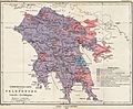
Ethnographic map of the Peloponnese, 1890

See also
 In Spanish: Peloponeso para niños
