
Maritsa facts for kids
Quick facts for kids Maritsa |
|
|---|---|

The source valley of the Maritsa river in the Rila Mountains with Marichini Lakes
|
|
| Other name(s) | Évros, Meriç |
| Countries | |
| Physical characteristics | |
| Main source | Rila Mountains, Bulgaria 2,378 m (7,802 ft) |
| River mouth | Aegean Sea, 14.5 km (9.0 mi) east of Alexandroupoli 40°43′50″N 26°2′6″E / 40.73056°N 26.03500°E |
| Length | 480 km (300 mi) |
| Basin features | |
| Basin size | 53,000 km2 (20,000 sq mi) |

The Maritsa River (also known as Meriç in Turkish and Evros in Greek) is a really important river in Southeast Europe. It flows through the Balkans region. It's about 480 kilometers (298 miles) long, making it the longest river that flows entirely within the Balkan Peninsula. It's also one of the largest rivers in Europe when you look at how much water it carries.
The Maritsa starts in Bulgaria and flows through its upper and middle parts. Then, its lower section forms a big part of the border between Greece and Turkey. The area where all its water collects, called its drainage area, is huge, about 53,000 square kilometers (20,463 square miles). Most of this area is in Bulgaria (66.2%), with parts in Turkey (27.5%) and Greece (6.3%). This river is super important for the historical region of Thrace.
The Maritsa River begins in the Rila Mountains in Western Bulgaria, specifically from the Marichini Lakes. It flows east-southeast, winding its way between the Balkan Mountains and the Rhodope Mountains. Along its path in Bulgaria, it passes by cities like Plovdiv and Dimitrovgrad.
When it reaches Edirne in Turkey, the river meets two of its main branches, the Tundzha and Arda rivers. East of Svilengrad, Bulgaria, the Maritsa flows eastward, creating a natural border between Bulgaria (on the north side) and Greece (on the south side). After that, it forms the border between Turkey and Greece. From Edirne, it turns south and continues to be the border between Greece (on the west) and Turkey (on the east) all the way to the Aegean Sea. It flows into the Aegean Sea near Enez, forming a river delta (a triangular landform at the mouth of a river).
The upper valley of the Maritsa is a key route for travel from east to west in Bulgaria. Even though you can't travel by boat on the river, its water is used to produce electricity and for watering crops.
Contents
River Names: Maritsa, Meriç, Evros
The Maritsa River has had different names throughout history. One of its oldest known names was Euros, which meant "wide" in ancient Greek. Over time, this name changed to Ebros in the Thracian language, and then to Hebrus in ancient Greek and Latin.
Later, the name Maritsa became common. Some people think this name might come from a mountain near the river's mouth called Merit(h)us in ancient times. Today, in modern Greek, the river is often called Evros, which is a return to its ancient name. In Turkish, it's known as Meriç.
Historical Events and the Maritsa
The Maritsa River has been important in history. In 1371, a famous battle called the Battle of Maritsa took place here. It was a big victory for the Ottoman Empire against Serbian rulers.
Because the Maritsa River forms a natural border between Turkey and Greece, it has become a route for people trying to travel between countries.
Maritsa River Branches


The Maritsa River has many smaller rivers that flow into it. These are called tributaries. They join the Maritsa from either its left or right side as it flows downstream.
- Left tributaries:
- Topolnitsa (joins near Pazardzhik)
- Luda Yana (joins near Ognyanovo)
- Stryama (joins near Sadovo)
- Sazliyka (joins near Simeonovgrad)
- Tundzha/Tunca (joins in Edirne)
- Ergene (joins near İpsala)
- Right tributaries:
- Chepinska reka (joins near Septemvri)
- Vacha (joins near Stamboliyski)
- Chepelarska reka (joins near Sadovo)
- Harmanliyska reka (joins near Harmanli)
- Arda/Ardas (joins near Edirne)
- Erythropotamos/Luda reka (joins near Didymoteicho)
Flooding Along the River


The lower part of the Maritsa River, where it forms the border between Greece and Turkey, often experiences floods. For about four months each year, the low-lying lands around the river can be covered in water. This causes a lot of damage to farms and buildings, costing millions of Euros.
There have been big floods recently, like in 2006, 2007, 2014, and the largest one in 2021. Experts think several things might cause these floods. This includes more rainfall due to climate change, fewer trees in the Bulgarian part of the river's area, more buildings in the flood plains, and sometimes it's hard for the three countries to talk to each other quickly about flood warnings.
Fun Facts About the Maritsa
- A mountain peak in Antarctica is named Maritsa Peak after this river! It's on Livingston Island in the South Shetland Islands.
- La Maritza is also the name of a famous 1968 song. It was written by Jean Renard and Pierre Delanoë and sung by Sylvie Vartan.
- There's even a valley on Mars called Hebrus Valles, named after the ancient name of this river.
- The Bulgarian Maritsa motorway also gets its name from the river. This highway generally follows the river's path from Chirpan to the Turkish border.
Gallery
-
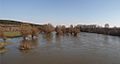
Spring freshet of Maritsa River at Harmanli
-
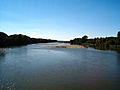
View from the river, Edirne.
-
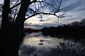
The river viewed from Turkey. Greek land visible on the right.
-
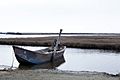
Boat on the delta.


