
Livingston Island facts for kids

Map of Livingston Island
|
|

Livingston
Location in South Shetland Islands

Livingston
Location in Antarctica
Location in the South Shetland Islands##Location in Antarctica
|
|
| Geography | |
|---|---|
| Location | Antarctica |
| Coordinates | 62°36′S 60°30′W / 62.600°S 60.500°W |
| Archipelago | South Shetland Islands |
| Area | 798 km2 (308 sq mi) |
| Length | 73 km (45.4 mi) |
| Width | 36 km (22.4 mi) |
| Highest elevation | 1,700.2 m (5,578.1 ft) |
| Highest point | Mt Friesland |
| Administration | |
| Administered under the Antarctic Treaty System | |
| Demographics | |
| Population | ca. 80 (summer only) |
| Pop. density | 0.1 /km2 (0.3 /sq mi) |
| Ethnic groups | Spaniards, Bulgarians, Chileans, Americans and Argentines |
| Highest elevation entry refers to the maximum value recorded, which is subject to possible variation as the island's highest summits are ice-covered. | |
Livingston Island (also known by its Russian name Smolensk) is an island in Antarctica. It's located in the Southern Ocean and is part of the South Shetland Islands. This island was the first land ever found south of 60° south latitude in 1819. This discovery was a big deal! It ended a long search for a mythical southern land and started the real exploration of Antarctica. The name Livingston has been used since the early 1820s, but nobody knows exactly where it came from.
Geography of Livingston Island
Livingston Island is in West Antarctica. It's about 110 km (68 mi) northwest of the Antarctic mainland. It's also 809 km (503 mi) south-southeast of Cape Horn in South America.
The island is part of the South Shetlands. This is a chain of islands stretching 510 km (317 mi). It's separated from the nearby Antarctic Peninsula by Bransfield Strait. The Drake Passage separates it from South America. The South Shetlands have a total land area of about 3,687 km² (1,424 sq mi). The main islands include Clarence, Elephant, King George, Nelson, Robert, Greenwich, Livingston, Deception, Snow, Low and Smith. There are also many smaller islands and rocks.
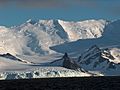
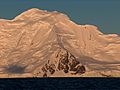
Livingston is separated from Greenwich Island by the 3.3 km (2.1 mi) wide McFarlane Strait. To the west, the 5.9 km (3.7 mi) wide Morton Strait separates it from Snow Island. Deception Island is only 18 km (11 mi) southwest of Livingston. Deception Island is an active volcano. Its last eruptions were in 1967, 1969, and 1970. Its flooded crater forms a sheltered harbor called Port Foster. Livingston Island itself has several extinct volcanoes. These include Rezen Knoll and Edinburgh Hill.


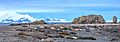
The island is 73 km (45 mi) long from west to east. Its width changes from 5 km (3 mi) to 36 km (22 mi). Livingston is the second largest island in the South Shetlands. Its surface area is about 798 km² (308 sq mi).
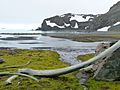
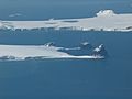
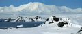
The coastline is very uneven. It has many large bays like South Bay and Hero Bay. There are also peninsulas like Hurd Peninsula and Byers Peninsula. Many small islands and rocks are found in the waters around Livingston. Some larger ones are Rugged Island and Half Moon Island.
.jpg)

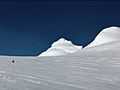
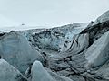
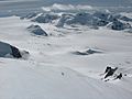
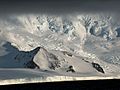
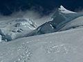
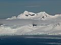
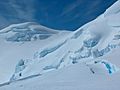
Most of the coastline is made of ice cliffs. These cliffs have been shrinking in recent years. This reveals new beaches and small islands. Most of the island is covered by an ice cap. This is a thick layer of ice. Some areas are very icy and hard to reach. Other parts are smooth and good for walking or skiing. However, hidden cracks in the ice, called crevasses, are always a danger.
The island also has layers of ash from volcanoes on nearby Deception Island. You can also find "rock glaciers" here. These are rocks frozen in ice.


Besides the large Byers Peninsula, some coastal areas are free of ice. These include Cape Shirreff and Hannah Point. Many streams flow in these ice-free areas during summer. Byers Peninsula alone has over 60 streams and lakes.
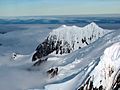
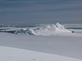
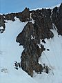
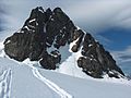
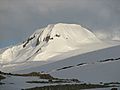
The main mountains on the island are the Tangra Mountains. They are 32 km (20 mi) long. Mt Friesland is the highest peak, rising to 1,700.2 m (5,578 ft). Other mountain ranges include Bowles Ridge and Vidin Heights. The ice on the mountains can change. In 2016, St. Boris Peak was almost as high as Mount Friesland.
The first people to climb Mount Friesland were Francesc Sàbat and Jorge Enrique in 1991. Other peaks in the Tangra Mountains were first climbed by Bulgarian explorers.
Captain Robert Fildes, a sealer, described the island in 1821:
On advancing from the northward toward Livingston's or the Main Island, the land will appear in mountains of a vast height, and covered entirely with snow; the base of them terminating in perpendicular ice cliffs. The whole has an awfully grand, though terrific and desolate, appearance; the snowy mountains showing themselves, one over another, far above the clouds, and exciting in the mind a devotional reverence on the wonders of the Almighty: and even if surrounded on all sides with rocks and breakers, the mind is forced into pious contemplation on the grandeur of the scene.
Climate of Livingston Island

Livingston Island has a polar tundra climate. This means it's very cold and dry. The weather is affected by several things. These include its location in the narrowest part of the Southern Ocean. Also, the Tangra Mountains help shape the local weather. The island's ice cap also plays a role. Temperatures get colder as you go higher up the mountains.

The weather here changes very quickly. It's often windy, humid, and cloudy. An Australian climber once said, "Livingston got just about the worst weather in the world." Strong storms can happen at any time of year. Whiteouts, where you can't see anything due to snow, are common. Temperatures stay pretty steady, not changing much during the day. The highest temperature recorded was 19.9 °C (67.8 °F). The lowest was −22.4 °C (−8.3 °F).
The Antarctic Peninsula region got warmer in the late 1900s. But in the early 2000s, it started to cool down. Livingston Island has cooled by about 0.8 °C (1.4 °F) between 2004 and 2016. This means snow stays on the ground longer in coastal areas.
It can rain or snow on Livingston Island at any time. But in winter, most of the precipitation is snow.
| Climate data for Juan Carlos I Antarctic Base (12 m AMSL), 1988–2007 | |||||||||||||
|---|---|---|---|---|---|---|---|---|---|---|---|---|---|
| Month | Jan | Feb | Mar | Apr | May | Jun | Jul | Aug | Sep | Oct | Nov | Dec | Year |
| Record high °C (°F) | 15.5 (59.9) |
11.0 (51.8) |
9.4 (48.9) |
8.7 (47.7) |
5.5 (41.9) |
5.9 (42.6) |
5.0 (41.0) |
6.9 (44.4) |
10.8 (51.4) |
10.6 (51.1) |
10.2 (50.4) |
15.0 (59.0) |
15.5 (59.9) |
| Daily mean °C (°F) | 2.6 (36.7) |
2.3 (36.1) |
1.3 (34.3) |
−0.3 (31.5) |
−1.5 (29.3) |
−3.8 (25.2) |
−4.6 (23.7) |
−4.4 (24.1) |
−3.4 (25.9) |
−2.3 (27.9) |
0.3 (32.5) |
1.4 (34.5) |
−1.0 (30.2) |
| Record low °C (°F) | −3.2 (26.2) |
−4.7 (23.5) |
−10.9 (12.4) |
−10.7 (12.7) |
−12.8 (9.0) |
−18.0 (−0.4) |
−22.4 (−8.3) |
−18.9 (−2.0) |
−16.9 (1.6) |
−15.0 (5.0) |
−8.9 (16.0) |
−7.0 (19.4) |
−22.4 (−8.3) |
| Average precipitation mm (inches) | 44.8 (1.76) |
58.5 (2.30) |
47.3 (1.86) |
43.0 (1.69) |
29.3 (1.15) |
10.1 (0.40) |
4.0 (0.16) |
7.7 (0.30) |
17.6 (0.69) |
45.3 (1.78) |
30.8 (1.21) |
38.8 (1.53) |
377.2 (14.85) |
| Average precipitation days | 16 | 17 | 15 | 16 | 11 | 6 | 4 | 6 | 12 | 17 | 13 | 15 | 148 |
| Average relative humidity (%) | 81 | 83 | 80 | 82 | 82 | 82 | 83 | 83 | 84 | 78 | 80 | 79 | 81.4 |
| Source: IPY | |||||||||||||
Flora and Fauna of Livingston Island

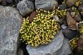
Charles Darwin, a famous scientist, visited nearby areas in 1832. He noticed that the South Shetland Islands, even though they are at the same latitude as southern Norway, only have some lichens, moss, and a little grass. This is because the ground underneath is frozen.
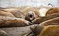
The coastal areas of Livingston Island are home to many plants and animals. You can find fur seals, elephant seals, Weddell seals, and leopard seals here. There are also different kinds of penguins, like chinstrap, gentoo, Adélie, and macaroni penguins. Many other seabirds, such as skuas and Antarctic terns, nest on the island in summer.
Scientists have found 110 types of lichens and 50 types of mosses near the Spanish base. This is the most plant diversity found in any single spot in Antarctica!
History of Livingston Island
Livingston Island was the first land discovered in what we now call Antarctica. In 1819, an English merchant named William Smith saw Williams Point on the island. This was the first time anyone had seen land south of 60° south latitude. This area is now part of the Antarctic Treaty System.
A Russian explorer named von Bellingshausen noted how surprising it was that this land was found so late. Ships had been sailing around Tierra del Fuego for over 200 years!

A few months after Smith's discovery, a Spanish warship called the San Telmo sank off Livingston Island in a storm. All 644 people on board were lost. They were the first recorded people to die in Antarctica. Parts of the ship were later found by sealers.

In December 1819, William Smith returned to the South Shetlands with Lieutenant Edward Bransfield. They were there to survey the new lands. On January 30, 1820, they saw the mountains of the Antarctic Peninsula. They didn't know that Russian explorers had already discovered the continent three days earlier.
A year later, Russian explorers arrived at Livingston Island. They saw many British and American ships. These ships were there for seal hunting. This industry started in 1819-1820.

Early sealers spent a lot of time on the island. They built stone huts or used caves for shelter. For a while, Livingston Island was the most populated place in Antarctica! Over 200 people lived there during the sealing rush from 1820-1823. The main sealer "settlements" were on Byers Peninsula and at Cape Shirreff. Archaeologists have found 26 shelter structures on Byers Peninsula alone. There were even some women among the early inhabitants. A grave of a young woman was found at Cape Shirreff, dating back to the early 1800s. Remains of huts and tools are still found on Livingston Island. It has the second-highest number of historical sites in Antarctica.
After sealing, whaling became a big industry in the 20th century. Livingston Island wasn't directly involved, but a whaling station operated on nearby Deception Island. Both sealing and whaling eventually stopped because too many animals were hunted. Then, in the 1970s, the fishing industry began.

A very important event for Livingston Island was the signing of the Antarctic Treaty in 1959. This treaty put the region south of 60° south latitude under shared control. It allowed for free scientific exploration. The treaty also froze any claims of ownership over Antarctic land. (For example, Britain, Chile, and Argentina had all claimed Livingston Island.) This treaty has helped countries work together in Antarctica. It also protects the environment and marine life.
Place Names on Livingston Island


Many places on Livingston Island are named after its early history. Some are named after ship captains like James Sheffield and Charles Barnard. Others are named after people like the shipowner James Byers. Some names come from sealing vessels, such as Huron and Williams.
Some place names describe the area. For example, Devils Point and Hell Gates are dangerous places where ships were lost. False Bay was sometimes confused with South Bay in bad weather. The Robbery Beaches are where American sealers had their sealskins stolen by the British. However, the origin of names like Livingston and Mount Friesland is still a mystery.


"Livingston" was the third name for the island. It replaced "Friesland Island" and "Smolensk." These older names are now used for Mount Friesland and Smolensk Strait. The name "Livingston" has nothing to do with the famous explorer David Livingstone, who was a child when the island was named.
Some place names are given by Argentina and Chile. For example, Charrúa Ridge and Scesa Point. Several Argentine names remember the crew of a plane that crashed on the island in 1976. Other names come from Spanish and Bulgarian explorers and scientists. These include Española Cove and Mount Reina Sofía. Hespérides Point is named after a Spanish research ship.
Scientific Bases and Camps


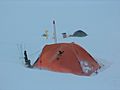
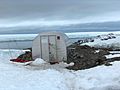
The first modern research camp on Livingston Island was British Station P in 1957-1958. Today, there are several scientific bases. The Juan Carlos I Base (Spain) and St. Kliment Ohridski (Bulgaria) were set up in 1988. The Doctor Guillermo Mann Base (Chile) and Cape Shirreff Field Station (USA) started in the 1990s. Cámara Base (Argentina) is on nearby Half Moon Island. Scientists from many countries visit these bases.
All four bases are used during the summer season. They can house about 92 people in total. This means about 80 people can be on Livingston Island itself. The actual number of people changes as some stay for only part of the season.


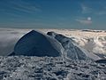
Scientists also use temporary field camps in remote areas. Camp Byers (Spain) is on Byers Peninsula. Camp Academia (Bulgaria) is high up in the Huron Glacier area. It's a good base for exploring the Tangra Mountains. This camp is named after the Bulgarian Academy of Sciences. It even has a summer post office!
Protected Areas and Sites


To protect Antarctica, the Antarctic Treaty System has strict rules. It sets aside special protected areas where access is only allowed for science and with special permission.
Livingston Island has two such protected areas, created in 1966. These are Antarctic Specially Protected Areas ASPA 149 Cape Shirreff and San Telmo Island and ASPA 126 Byers Peninsula. Byers Peninsula is the largest ice-free area in the South Shetlands. Cape Shirreff is a smaller peninsula.
These areas protect fossils that show how Antarctica is linked to other southern continents. They also protect many plants and animals, including seal and penguin colonies. These colonies are studied by scientists. Byers Peninsula is also an Important Bird Area because of its breeding colonies of Antarctic terns and kelp gulls. ASPA 149 has the largest Antarctic fur seal breeding colony in the region. Fur seals are no longer hunted and have returned to their old homes.


The protected area of Byers Peninsula was expanded in 2016. It now includes all ice-free land west of Clark Nunatak. Two special zones within these areas have even stricter rules. This is to prevent humans from bringing germs or other pollution.
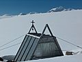
There are also two Historic Sites or Monuments on the island. The San Telmo Cairn at Cape Shirreff remembers the 644 people lost on the San Telmo in 1819. The Lame Dog Hut at the Bulgarian base is the oldest preserved building on Livingston Island. It's now a museum about the island's history.
Tourism on Livingston Island


Tourism in Antarctica started in 1957-1958. Now, tens of thousands of tourists visit every year. Most of them visit the South Shetlands and the nearby Antarctic Peninsula. Popular spots on Livingston Island include Hannah Point and Half Moon Island. Tourists usually arrive on cruise ships. They use small inflatable boats called Zodiacs to land on shore. They walk along marked trails, led by guides, to see the beautiful scenery and wildlife. Zodiac boats are great for moving around in icy waters. This is only possible in summer, as the sea freezes in winter. Yacht visits and extreme sports like kayaking are also becoming popular.
_30.jpg)
Some cruise ships visit the Bulgarian base. Tourists can see the Livingston Island Museum, which opened in 2012. They can also visit the old and new chapels of St. Ivan Rilski. This was the first Eastern Orthodox building in Antarctica. There's also a monument to the Cyrillic alphabet here. The way Bulgarian place names are written in English was developed for Livingston Island in 1995.
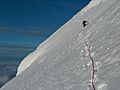
The northeastern slopes of the Tangra Mountains are popular for backcountry skiing and climbing. Skiers are dropped off by Zodiac boats from cruise ships.

Honours
Several places in Bulgaria are named after Livingston Island. These include "Livingston Island Square" in Samuil and Kula, and "Livingston Island Street" in cities like Sofia and Yambol.
Images for kids
-
Hurd Peninsula and Rozhen Peninsula from Hannah Point
-
Elephant seals on Liverpool Beach
-
Polish Bluff from Argentina Cove
-
Antarctic pearlwort, one of the two native flowering plants
-
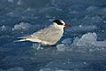
Antarctic tern at Cape Shirreff
-
St. Boris Peak from Mt Friesland
-
Helmet Peak
-
Pliska Ridge and Burdick Ridge
-
Orpheus Gate
-
Volcanic ash layers in Perunika Glacier
-
Bowles Ridge
-
Kubrat Knoll, Inott Point and Edinburgh Hill
-
Komini Peak
-
Atanasoff Nunatak
-
Yambol Peak
-
Ongal Peak
-
Elena Peak and Yavorov Peak
-
Zograf Peak
-
Needle Peak
-
Delchev Peak
-
Rezen Knoll
-
On a survey mission
-
Wedding in Livingston Island's waters
-
Livingston Island's Christmas tree
-
Spanish refuge at Mount Reina Sofía
-

The old Spanish base
-
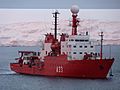
BIO Hespérides in South Bay
-
The old St. Ivan Rilski Chapel
-
Tangra Mountains from Chilean and US base vicinity
%E2%80%93Southern_elephant_seal_(Mirounga_leonina)_01.jpg)


.jpg)


Maps

- Islas Shetland del Sur de Isla 25 de Mayo a Isla Livingston. Mapa hidrográfico a escala 1:200000. Buenos Aires: Servicio de Hidrografía Naval de la Armada, 1980
- Islas Livingston y Decepción. Mapa topográfico a escala 1:100000. Madrid: Servicio Geográfico del Ejército, 1991
- L. Ivanov. St. Kliment Ohridski Base, Livingston Island. Scale 1:1000 topographic map. Sofia: Antarctic Place-names Commission of Bulgaria, 1996. (First Bulgarian Antarctic topographic map; original version)

- L. Ivanov. Livingston Island: Central-Eastern Region. Scale 1:25000 topographic map. Sofia: Antarctic Place-names Commission of Bulgaria, 1996
- S. Soccol, D. Gildea and J. Bath. Livingston Island, Antarctica. Scale 1:100000 satellite map. The Omega Foundation, USA, 2004
- L. Ivanov et al. Antarctica: Livingston Island and Greenwich Island, South Shetland Islands (from English Strait to Morton Strait, with illustrations and ice-cover distribution). Scale 1:100000 topographic map. Sofia: Antarctic Place-names Commission of Bulgaria, 2005
- L. Ivanov. Antarctica: Livingston Island and Greenwich, Robert, Snow and Smith Islands. Scale 1:120000 topographic map. Troyan: Manfred Wörner Foundation, 2010. ISBN: 978-954-92032-9-5 (First edition 2009. ISBN: 978-954-92032-6-4)
- L. Ivanov. Antarctica: Livingston Island and Smith Island. Scale 1:100000 topographic map. Manfred Wörner Foundation, 2017. ISBN: 978-619-90008-3-0
See also
 In Spanish: Isla Livingston para niños
