Port Foster facts for kids
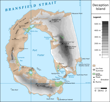
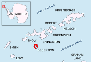
Port Foster is a very safe harbour in Antarctica. It is found on Deception Island in the South Shetland Islands. This special harbour is actually inside a volcano!
Contents
A Look Back: Port Foster's Past
Early Days and Names
Sailors who hunted seals knew about this harbour way back in 1820. At first, they called it Port Williams. This name came from the ship Williams, which belonged to Captain William Smith. Some also called it Yankee Harbor because many American seal hunters used it as a safe place to stop.
How Port Foster Got Its Name
Later, the harbour was named Port Foster. It was named after Henry Foster. He was the captain of a ship called the HMS Chanticleer. Captain Foster led the first scientific trip to Deception Island. This happened between January and March in 1829.
His team set up their base in Pendulum Cove. They took important measurements of gravity and magnetism. They also created the very first topographic map of the area. This map showed the shape of the land. They measured temperatures and studied the water depths too.
Names That Still Exist
Some of the old names for the harbour are still used today. But now, they refer to other places nearby. For example, you can find Williams Point and Yankee Harbor in the same group of islands.
What Port Foster Looks Like

The middle of Deception Island is a giant hole called a caldera. This caldera was made by a huge volcanic eruption a long time ago. After the eruption, the hole filled with water. This created the large, bowl-shaped harbour of Port Foster. It is about 10 by 7 km (6.2 by 4.3 mi) in size.
Neptune's Bellows: The Entrance
The only way into Port Foster is through a narrow opening. This entrance is only 560 m (1,840 ft) wide. It is called Neptune's Bellows. Imagine a giant's breath pushing ships through!
Special Underwater Life
The bottom of Port Foster, called the benthic zone, is very interesting for scientists. This is because the volcanic activity often changes the environment. These natural changes make it a unique place for different kinds of sea life to live.
Two parts of this area are specially protected. They are known together as Antarctic Specially Protected Area (ASPA) No.145. This helps keep the unique ecosystem safe.
See also
 In Spanish: Puerto Foster para niños
- Stancomb Cove
- Stanley Patch
- Wensleydale Beacon
 | James Van Der Zee |
 | Alma Thomas |
 | Ellis Wilson |
 | Margaret Taylor-Burroughs |


