
Deception Island facts for kids

Map of Deception Island
|
|

Deception Island
Location in South Shetland Islands

Deception Island
Location in Antarctica
Location in the South Shetland Islands##Location in Antarctica
|
|
| Geography | |
|---|---|
| Location | Antarctica |
| Coordinates | 62°58′37″S 60°39′00″W / 62.97694°S 60.65000°W |
| Area | 72 km2 (28 sq mi) |
| Length | 12 km (7.5 mi) |
| Width | 12 km (7.5 mi) |
| Highest elevation | 542 m (1,778 ft) |
| Highest point | Mount Pond |
| Administration | |
| Administered under the Antarctic Treaty System | |
| Demographics | |
| Population | 0 |
| Deception Island | |
|---|---|

Entrance to Deception Island, with Livingston Island in the background
|
|
| Highest point | |
| Elevation | 576 m (1,890 ft) |
| Prominence | 576 m (1,890 ft) |
| Geography | |
| Location | Antarctica |
| Geology | |
| Mountain type | Caldera |
| Last eruption | August 1970 |
Deception Island is a unique island in Antarctica. It's part of the South Shetland Islands, located near the Antarctic Peninsula. This island is actually the top of an active volcano. Its special shape creates a large, safe natural harbor.
Because it's an active volcano, Deception Island has had eruptions. These eruptions caused damage to scientific stations in 1967 and 1969. In the past, the island was a busy place for whaling. Today, it's a popular spot for tourists and a base for scientific research. Both Argentina and Spain have research stations here. Even though different countries have claimed the island, it is managed under the Antarctic Treaty System. This system ensures the area is used for peaceful scientific research.
Contents
Exploring Deception Island's Geography

.jpg)
Deception Island is shaped like a horseshoe or a ring. It's about 15 kilometers (9 miles) wide. The highest point is Mount Pond, which is 539 meters (1,768 feet) tall. More than half of the island is covered by thick glaciers.
Port Foster: The Flooded Volcano Center
The middle of the island is a huge bay called Port Foster. This bay was formed when the volcano's center collapsed and filled with sea water. Port Foster is about 10 kilometers (6 miles) long and 7 kilometers (4 miles) wide.
The only way into Port Foster is through a narrow opening called Neptune's Bellows. It's only about 500 meters (1,640 feet) wide. Inside this entrance, there's a dangerous rock called Raven's Rock, which is just below the water.
Unique Features of the Island
Just inside Neptune's Bellows is Whalers Bay. It has a large black sand beach. You can also find several maars (volcanic craters) around the island. Some of these craters have lakes inside them. Other interesting places include Mount Kirkwood, Fumarole Bay, Sewing-Machine Needles, and Telefon Bay.
Scientists have studied nearby Ardley Island. They found that penguin populations there crashed several times over 7,000 years. This was due to big volcanic eruptions from Deception Island. The island has had several large eruptions in the last 10,000 years.
Deception Island's Volcanic Nature
Deception Island is the visible part of a large, active shield volcano. The island experiences frequent small earthquakes from depths less than 10 kilometers (6 miles). Major eruptions happened in 1839–42, 1967, 1969, and 1970.
The island's rocks show its volcanic history. Some parts are made of volcanic ash and lava. Other parts show layers from explosive eruptions. The large bay, Port Foster, formed when the volcano's top collapsed. This happened either during a huge eruption or because of movements in the Earth's crust.
A Look Back: Deception Island's History

The first time Deception Island was officially seen was in January 1820 by British sealers. The first person to visit and explore it was an American sealer named Nathaniel Palmer in November 1820. He stayed for two days and explored the central bay. Palmer named it "Deception Island" because it looked like a normal island from the outside. But its narrow entrance, Neptune's Bellows, showed it was actually a ring around a flooded volcano.
Sealing and Whaling Era
In the early 1800s, Deception Island became important for fur-sealing. It was a perfect natural harbor, mostly free from ice and strong winds. This made it a good meeting point for ships. However, too many seals were hunted, and the industry quickly ended around 1825.
Later, in the early 1900s, whaling became big. Whalers needed sheltered places and fresh water. Deception Island had both. In 1906, a Norwegian-Chilean whaling company started using Whalers Bay as a base.
Many other whalers followed. Hundreds of men lived on the island during the Antarctic summers. In 1908, the British government declared the island part of the Falkland Islands Dependencies. They set up postal services and appointed a magistrate to collect fees and manage whaling. A cemetery was built in 1908, and a radio station in 1912.
In 1912, a permanent shore-based whaling station was built. This was the only successful shore-based whaling operation in Antarctica. However, new whaling ships that could process whales at sea meant companies no longer needed shore bases. By 1931, commercial whaling on Deception Island stopped.
Scientific Research and Volcanic Impact
On November 16, 1928, Hubert Wilkins made the first flight in Antarctica from a runway at Whalers Bay.
After the whaling era, the island was empty for a decade. During World War II, British ships destroyed oil tanks on the island to prevent them from being used by enemies. In 1942, Argentina claimed the island, but Britain removed their signs the next year.
In 1944, a British expedition set up a permanent scientific base called Station B. However, the volcano became active again in 1967 and 1969. These eruptions destroyed the British and Chilean scientific stations. The island was abandoned for several years. The last major eruption was in August 1970.
Today, there are two scientific stations that operate only in the summer: the Spanish Gabriel de Castilla Base and the Argentinian Decepción Station. You can still see remains of old structures at Whalers Bay, like rusting boilers and a damaged aircraft hangar.
Visiting Deception Island: Tourism

The first commercial cruise ship visited Deception Island in January 1966. By 1999, over 10,000 tourists had visited the island. It's a popular stop in Antarctica.
Research Stations on Deception Island
Several countries have had research stations on Deception Island.
Aguirre Cerda Station
President Pedro Aguirre Cerda Station was a Chilean base. It opened in 1955 but was evacuated in December 1967 due to volcanic eruptions.
Deception Station
Deception Station is an Argentine base. It was founded in 1948 and was a year-round station until the 1967 volcanic eruptions. Since then, it has been used only during the summer.
Gabriel de Castilla Base
Gabriel de Castilla Base is a Spanish research station. It was built in 1990 and operates during the summer.
Gutiérrez Vargas Refuge
The Gutiérrez Vargas Refuge was a Chilean refuge near Aguirre Cerda Station. It was built in 1956 to provide safety in case of fire. It was abandoned in 1967 due to the volcanic eruption. You can still see its remains on the beach.
Station B
Station B was a British scientific base. It was occupied from 1944 until December 1967, when an eruption forced them to leave. It was used again briefly in 1968-1969 before more volcanic activity caused it to be abandoned permanently.
Deception Island's Environment


_43.jpg)

Deception Island is a favorite tourist spot in Antarctica. People come to see its many colonies of chinstrap penguins. They also enjoy digging into the warm sands on the beach for a natural hot bath. Mount Flora on the island is special because it's where the first fossilized plants in Antarctica were found.
In 2007, a cruise ship ran aground near Deception Island, and some fuel spilled. However, tests later showed that the water and sand were clean, with no signs of oil.
The island has very different local climates. Near volcanic areas, the air can be as hot as 40°C (104°F), and water can reach 70°C (158°F).
Protected Areas for Nature
Eleven land sites on Deception Island are protected as an Antarctic Specially Protected Area (ASPA 140). These areas are important because the island has the most rare plant species in Antarctica. The frequent volcanic activity creates new ground for plants to grow.
- Collins Point (Site A) has old vegetation with many different plant types.
- Crater Lake (Site B) has unique plants, including thick mosses.
- A hill at Fumarole Bay (Site C) has rare mosses growing on warm soil near volcanic vents.
- Fumarole Bay (Site D) has the most diverse plant life on the island.
- West Stonethrow Ridge (Site E) supports rare mosses, liverworts, and lichens.
- Telefon Bay (Site F) is a good place to watch how plants and animals grow on new land formed in 1967.
- Pendulum Cove (Site G) is another area where scientists study how mosses and lichens grow on new land.
- Mount Pond (Site H) has amazing moss, liverwort, and lichen communities.
- Perchue Cone (Site J) is a volcanic cone with rare mosses.
- Ronald Hill to Kroner Lake (Site K) is another area where many different plants are growing on new land, and the lake shore has unique algae.
- South East Point (Site L) has the largest group of Antarctic pearlwort in the Antarctic.
Also, two marine areas in Port Foster (ASPA 145) are protected to save their sea bottom communities.
Important Bird Area
Baily Head, a prominent point on the east side of the island, is an Important Bird Area (IBA). This is because it has a very large breeding colony of chinstrap penguins, with 100,000 pairs! Other birds that nest here include brown skuas, Cape petrels, and snowy sheathbills.
Images for kids
-
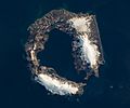
Landsat 8 satellite photograph taken on 23 March 2018

See also
 In Spanish: Isla Decepción para niños
