
Deception Pass facts for kids
Quick facts for kids Deception Pass State Park |
|
|---|---|

Aerial view of Deception Pass looking southeast
|
|

Located in the northern Puget Sound region, Deception Pass (circled in red) connects the Strait of Juan de Fuca (to the west) to Skagit Bay (to the east). Fidalgo Island is to the north and Whidbey Island is to the south.
|
|
| Type | State park |
| Location | Anacortes and Oak Harbor, Washington, United States |
| Area | 3,854 acres (1,560 ha) |
| Created | 1922 Developed by the Civilian Conservation Corps in the 1930s |
| Operated by | Washington State Parks |
| Visitors | 2,000,000+ annually |
| Open | Year-round |
| Website | Deception Pass State Park |
Deception Pass is a narrow waterway, called a strait, in the northwest part of Washington. It separates Whidbey Island from Fidalgo Island. This strait connects Skagit Bay, which is part of Puget Sound, with the Strait of Juan de Fuca. Two large bridges, known together as the Deception Pass Bridge, cross over Deception Pass. These bridges were added to the National Register of Historic Places in 1982 because of their historical importance.
Contents
Discovering Deception Pass

The area around Deception Pass has been home to different Coast Salish tribes for thousands of years. The first Europeans to see Deception Pass were from a Spanish expedition in 1790. They called it Boca de Flon.
Later, in 1792, a group of sailors led by Joseph Whidbey explored and mapped Deception Pass. They were part of the Vancouver Expedition. George Vancouver named it "Deception" because the strait had tricked him. He first thought Whidbey Island was connected to the mainland, like a peninsula.
Here's how the "deception" happened:
- In May 1792, Vancouver was anchored near the south end of Whidbey Island.
- He sent Joseph Whidbey to explore the waters to the east, now called Saratoga Passage.
- Whidbey sailed into Skagit Bay, which was shallow and hard to navigate. He didn't find the strait that connected to the other side.
- It seemed like Skagit Bay was a dead-end. So, Vancouver thought Whidbey Island and Fidalgo Island were one long piece of land connected to the mainland.
- In June, the expedition sailed north along the west coast of Whidbey Island. Vancouver sent Whidbey to explore inlets leading east again.
- This time, Whidbey found a "very narrow and intricate channel" that was full of rocks.
- This channel led to Skagit Bay, proving that Whidbey Island was actually an island, not a peninsula!
- Vancouver felt he and Whidbey had been tricked by the tricky strait. He wrote that because of Whidbey's discovery, he named the land "Whidbey's Island" and the northern passage into Skagit Bay, "Deception Passage."
A small island called Ben Ure Island is located in Deception Pass, just east of the bridges.
Between 1910 and 1914, a rock quarry was operated by people serving time from a prison. It was on the Fidalgo Island side of the pass. About 40 people lived in nearby buildings. Guards watched as they cut rock into gravel. This gravel was then loaded onto boats at the bottom of the cliff. The rock was taken by boat to the Seattle waterfront. The camp was taken down in 1924. Even though it's no longer a quarry, you can still find parts of the old camp. It's a dangerous area, and some accidents have happened when visitors went onto the steep cliffs.
On July 31, 1935, the Deception Pass Bridge was finished. This bridge is 976-foot (297 m) long. It connected Whidbey Island to a tiny island called Pass Island, and then Pass Island to Fidalgo Island. Before the bridge, people used a ferry boat to travel between Fidalgo and Whidbey islands.
Amazing Currents
Deception Pass is known for its dramatic water. The ocean's tides create fast-moving currents and whirlpools under the twin bridges. During both high and low tides, the water can flow as fast as 8 knots (9.2 mph). The currents flow in opposite directions depending on the tide.
This swift current can create standing waves, large whirlpools, and swirling eddies. You can see this amazing sight from the walking paths on the bridges. You can also see it from the trail below the larger south bridge. Boats often wait on either side of the pass for the current to slow down or change direction before they go through. Some adventurous kayakers even go there during big tide changes to surf the standing waves. They brave the challenging water conditions, which are like Class 2 and 3 rapids.
Diving in the Pass
Diving in Deception Pass is very challenging and only for experienced divers. There are only a few times each year when the tides are just right for a special kind of dive. Divers can float with the current from a cove, under the bridge, and back to the cove as the tide changes. These dives need careful planning by divers who understand currents and dangerous conditions.
However, because of the strong tides, Deception Pass has some of the most colorful and lively underwater scenes in the Pacific Northwest. The walls and bottom are covered with colorful sea creatures. You can see lingcod, greenlings, and barnacles everywhere.
Deception Pass State Park

Deception Pass is surrounded by the 3,854-acre (1,560 ha) Deception Pass State Park. This is one of the most visited state parks in Washington, with over two million visitors every year.
Park History
The park officially started in 1923. At that time, 1,600 acres (650 ha) of land that used to be a military area was given to Washington State Parks. The park's facilities were greatly improved in the 1930s. The Civilian Conservation Corps (CCC) built roads, trails, and buildings to help develop the park.
In 1950, the road to West Beach was built. This opened up a long stretch of beach for many vehicles. The old fish hatchery at Bowman Bay became part of the park in the early 1970s. The park's old entrance was closed in 1997. A new entrance was created at the intersection of Highway 20 and Cornet Bay road. This made it easier to get into and out of the park.
Things to Do and See
The park has many fun things to do. These include campgrounds, hiking trails, beaches, and tidepools. Several miles of the Pacific Northwest Trail are inside the park. A notable part of this trail crosses Deception Pass on the Highway 20 bridge.
The Cornet Bay Retreat Center offers cabins and places for dining and recreation. Cornet Bay also has boat launches and good fishing spots. Bowman Bay has a special center that tells the story of the Civilian Conservation Corps in Washington state. Near this center, there is a statue honoring the CCC. You can find similar statues in 30 different states. Fishing is popular in Pass Lake, which is on the north side of the bridge. You can also rent boats and take guided tours of the park.
Park Islands
The park includes ten islands. These are Northwest Island, Deception Island, Pass Island, Strawberry, Ben Ure, Kiket, Skagit, Hope, and Big and Little Deadman Islands. Ben Ure Island is partly owned by private individuals. This island is not open to the public. However, there is a small cabin you can rent through the state park. It can only be reached by rowboat.

Images for kids
-
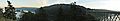
View looking south from Pass Island. From left to right, are visible Strawberry Island, part of Ben Ure Island, the bulk of Whidbey Island and the south span of the Deception Pass Bridge.
-
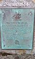
Plaque explaining the history of Deception Pass: Deception Pass - Named By Captain George Vancouver 10 June 1792. Feeling That He Had Been "Deceived" As To The Nature Of The Inner Waterway, Port Gardner (Now Saratoga Passage) he Wrote On His Chart "Deception Pass."

