Puget Sound facts for kids
Quick facts for kids Puget Sound |
|
|---|---|
| x̌ʷəlč (Lushootseed) | |
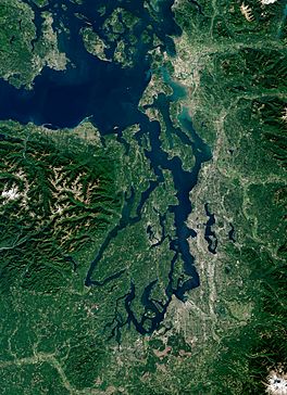
Satellite view of Puget Sound and surrounding waterways, taken by Sentinel-2 in September 2018
|
|
 |
|
| Location | Puget Sound Lowlands, Washington, U.S. |
| Coordinates | 47°36′N 122°24′W / 47.6°N 122.4°W |
| Etymology | Peter Puget |
| Part of | Salish Sea |
| Primary inflows | Deschutes River, Nisqually River, Puyallup River, Duwamish River, Cedar River, Snohomish River, Stillaguamish River, Skagit River |
| Primary outflows | Admiralty Inlet, Deception Pass avg: 41,000 cu ft/s (1,200 m3/s) max: 367,000 cu ft/s (10,400 m3/s) min: 14,000 cu ft/s (400 m3/s) |
| Catchment area | 12,138 sq mi (31,440 km2) |
| Max. length | 100 mi (160 km) |
| Max. width | 10 mi (16 km) |
| Surface area | 1,020 sq mi (2,600 km2) |
| Average depth | 450 ft (140 m) |
| Max. depth | 930 ft (280 m) |
| Water volume | 26.5 cu mi (110 km3) |
| Settlements | Seattle, Tacoma, Olympia, Everett, Bremerton |
Puget Sound (pronounced PYOO-jit) is a large body of water on the northwestern coast of Washington. It's a complex system of connected waterways and basins, like a giant puzzle of water. Puget Sound is part of the larger Salish Sea.
It connects to the open Pacific Ocean through the Strait of Juan de Fuca. The main way in is Admiralty Inlet. There are also smaller connections like Deception Pass and the Swinomish Channel.
Puget Sound stretches about 100 miles (160 km) from north to south. Its average depth is about 450 feet (140 m). The deepest spot is 930 feet (280 m) deep, near Jefferson Point. The main part of the Sound, between Whidbey Island and Tacoma, is about 600 feet (180 m) deep.
In 2009, the name Salish Sea was created. It includes Puget Sound, the Strait of Juan de Fuca, and the Strait of Georgia. Sometimes, people use "Puget Sound" to also mean nearby waters like Bellingham Bay and the San Juan Islands.
The term "Puget Sound" can refer to the water itself or the whole area around it. Big cities like Seattle, Tacoma, Olympia, and Everett are located on its shores. Puget Sound is the second-largest estuary in the United States, after Chesapeake Bay. An estuary is where fresh river water mixes with salty ocean water.
Contents
How Puget Sound Got Its Name
In 1792, a British explorer named George Vancouver explored these waters. He named the southern part "Puget's Sound" after one of his officers, Peter Puget. Later, this name was used for the entire area.
Native American tribes in the region have their own name for Puget Sound. They call it Whulge (or Whulj), which means "sea, salt water, ocean, or sound" in their Lushootseed language.
What Exactly Is Puget Sound?
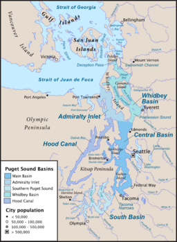
Different groups define Puget Sound in slightly different ways. The USGS says Puget Sound includes all the waters south of three main entrances from the Strait of Juan de Fuca. These entrances are at Admiralty Inlet, Deception Pass, and the Swinomish Channel. This definition includes places like Hood Canal and Possession Sound.
Another group, the NOAA, divides Puget Sound into five areas. Their "Northern Puget Sound" area is much larger. It even includes parts of the Strait of Juan de Fuca and the Strait of Georgia.
So, when people say "Puget Sound," they might be talking about slightly different areas. However, the term Salish Sea now helps to describe the larger water system.
How Glaciers Shaped Puget Sound
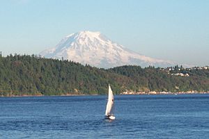
Long ago, huge sheets of ice called glaciers covered the Puget Sound area many times. The most recent time was about 15,000 years ago. A giant ice sheet, called the Puget Lobe, spread south. It was about 3,000 feet (900 m) thick near Seattle! This ice covered the lowlands between the Olympic and Cascade mountains.
Around 14,000 years ago, the ice started to melt and retreat. By 11,000 years ago, it was gone from this area. As the ice melted, it carved out the land. This is how places like Lake Washington, Lake Sammamish, Hood Canal, and the main Puget Sound basin were formed. The melting ice also left behind a lot of rock and dirt, which makes up the soil in the region today.
The huge weight of the ice pushed the land down. After the ice melted, the land slowly rose back up. This process, along with rising sea levels, caused the Puget Sound area to fill with water, sometimes fresh and sometimes salty.
Deep Basins and Sills
The Puget Sound system has four deep areas, like giant bowls, connected by shallower underwater ridges called sills.
- Hood Canal (west of the Kitsap Peninsula)
- Whidbey Basin (east of Whidbey Island)
- South Sound (south of the Tacoma Narrows)
- The Main Basin (which includes Admiralty Inlet and the Central Basin)
These sills act like underwater speed bumps. They control how water flows between the Strait of Juan de Fuca and Puget Sound. Important sills are at Admiralty Inlet, the entrance to Hood Canal, and the Tacoma Narrows.
Water Flow and Tides
Puget Sound is a large saltwater estuary. It gets fresh water from rivers flowing down from the Olympic and Cascade Mountains. The amount of fresh water changes a lot with the seasons.
The Sound has a shoreline of about 1,332 miles (2,144 km). Its water area is about 1,020 square miles (2,640 km²). A huge amount of water, about 1.26 cubic miles (5.2 km³), flows in and out of Puget Sound with each tide. The fastest tidal currents, up to 9 to 10 knots (17 to 19 km/h), happen at Deception Pass.
The tides in Puget Sound are "mixed." This means there are two high tides and two low tides each day, but they are not all the same height. The difference between the highest high tide and the lowest low tide gets bigger as you go further into Puget Sound. For example, it's about 8.3 feet (2.5 m) at Port Townsend, but it increases to about 14.4 feet (4.4 m) at Olympia, at the very southern end of the Sound.
Puget Sound is also considered the start of the Inside Passage, a famous water route along the coast.
Amazing Animals and Plants of Puget Sound


Puget Sound is home to many different kinds of plants and animals.
Marine Plants
Important marine plants include eelgrass and various types of kelp. Bull kelp forms large underwater forests.
Marine Mammals
You can find harbor seals in Puget Sound. Orcas, also known as "killer whales," are famous here. While you might see them in Puget Sound, they are more common around the San Juan Islands to the north.
Fish Species
Many fish live in Puget Sound. Different types of salmon, trout, and char are well-known. These include chinook, chum, coho, pink, and sockeye salmon. You can also find steelhead trout and bull trout.
Smaller "forage fish" like Pacific herring and surf smelt are important because they are food for bigger animals. Larger fish like Pacific cod and walleye pollock also live here. There are also about 28 different kinds of rockfish!
Other fish you might find include sturgeons, lampreys, and various sharks, rays, and skates.
Invertebrates
Puget Sound has many marine invertebrates, which are animals without backbones. These include sponges, sea anemones, clams, sea snails, crabs, starfish, and sea urchins. Dungeness crabs are common. Many types of clams and oysters live here, too. The geoduck clam (pronounced "gooey duck") is a very large clam that is considered a special food in some countries.
Birds
Many seabirds call Puget Sound home. These include grebes, loons, and auks like the pigeon guillemot. You can also see brant geese, seaducks like the long-tailed duck, and cormorants. A special type of great blue heron lives here and does not migrate. Bald eagles are also common in the Puget Sound area.
History of Puget Sound
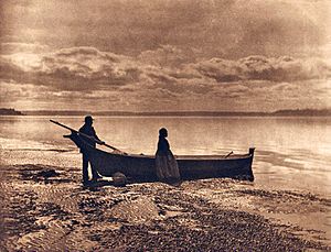
Indigenous peoples, such as the Lushootseed-speaking tribes, have lived in the Puget Sound region for thousands of years. The earliest signs of people here date back to between 14,000 and 6,000 BCE.
In 1792, British Royal Navy captain George Vancouver explored Puget Sound. He claimed the area for Great Britain and named it after his officer, Peter Puget. He also named the whole region "New Georgia" after King George III.
For a while, both Britain and the United States claimed this land. This was settled in 1846 with the Oregon Treaty, and Puget Sound became part of the U.S.
The first non-Indigenous settlement in the area was Fort Nisqually. It was a fur trading post built by the Hudson's Bay Company in 1833. This company also started farming to get resources. Later, the timber industry (lumber) became very important.
The first American settlers arrived in 1845 and founded Tumwater. In 1853, Washington Territory was formed. In 1888, the Northern Pacific railroad reached Puget Sound, connecting the region to the eastern United States. Washington became a state in 1889.
Getting Around Puget Sound
The Washington State Ferries (WSF) system is a state-run ferry service. It connects the many of Puget Sound to the mainland. It also links the Olympic Peninsula and Kitsap Peninsula. These ferries carry both people and cars. It is the largest ferry operator in the United States.
Protecting Puget Sound's Environment
Over the last 30 years, the number of people living around Puget Sound has grown a lot. Sadly, this has led to a decrease in many plant and animal species. Fish like salmon, and marine animals like orcas, have seen their populations drop.
This decline is caused by several things:
- More people living in the area.
- Pollution entering the water.
- Changes to habitats along the shore.
- Climate change.
Because of these problems, there have been changes to fishing rules. Also, more species are being added to the Endangered Species Act to protect them. Many plans are now in place to help these species recover and manage the environment better.
The main environmental issues are toxic chemicals, too many nutrients (which can cause low oxygen in the water), and changes to the habitats near the shore.
In 1978, there was an accident where some radioactive water was released into Puget Sound from a submarine. This was a mistake during maintenance.
See also
 In Spanish: Estrecho de Puget para niños
 | Jackie Robinson |
 | Jack Johnson |
 | Althea Gibson |
 | Arthur Ashe |
 | Muhammad Ali |


