
Nisqually River facts for kids
Quick facts for kids Nisqually River |
|
|---|---|

Nisqually River near Ashford during a flood in 2006 that destroyed a campground in Mount Rainier National Park
|
|


Location of the mouth of the Nisqually River in Washington
|
|
| Country | United States |
| State | Washington |
| District | Nisqually Indian Reservation, Fort Lewis |
| Physical characteristics | |
| Main source | Nisqually Glacier Mount Rainier 4,809 ft (1,466 m) 46°47′39″N 121°44′54″W / 46.79417°N 121.74833°W |
| River mouth | Puget Sound Nisqually National Wildlife Refuge 0 ft (0 m) 47°6′31″N 122°42′11″W / 47.10861°N 122.70306°W |
| Length | 81 mi (130 km) |
| Basin features | |
| Basin size | 517 sq mi (1,340 km2) |
| Tributaries |
|

The Nisqually River is a river in west-central Washington in the United States. It is about 81 miles (130 kilometers) long. This river collects water from part of the Cascade Range mountains, including the southern side of Mount Rainier. It then flows into the southern part of Puget Sound. The area where it meets Puget Sound is called the Nisqually Delta. In 1971, this delta was named a special protected place called the Nisqually Delta National Natural Landmark.
The Nisqually River also forms borders between different counties. It separates Pierce and Lewis counties, and also Pierce and Thurston counties.
Contents
Journey of the Nisqually River
Where the River Begins
The Nisqually River starts high up in the southern part of Mount Rainier National Park. Its water comes from the melting ice of the Nisqually Glacier on Mount Rainier.
Flowing Through Towns and Dams
As the river flows, it passes through small towns like Ashford and Elbe. You can see it alongside Route 706. Further down, the river's flow is controlled by two dams. The Alder Dam was finished in 1944, and the LaGrande Dam was rebuilt in 1945. These dams create large lakes, called reservoirs, like Alder Reservoir. Before these dams were built, certain fish could not swim upstream past where the LaGrande Reservoir is now.
Journey to Puget Sound
After Elbe, the river turns northwest. It flows through rolling hills and passes near McKenna, Washington. It also goes through Fort Lewis and the Nisqually Indian Reservation. The river then flows under Interstate 5 and enters the Nisqually River Delta. This delta is home to the Nisqually National Wildlife Refuge. The entire delta, including land owned by the government and private citizens, was made a National Natural Landmark in 1971. The Nisqually River finally reaches the Nisqually Reach part of Puget Sound about 15 miles (24 kilometers) east of Olympia.
History of the Nisqually River Area
The Nisqually People and Their Land
The Nisqually River is very important to the Nisqually tribe. The river is even named after them. This area was their traditional home, though they also lived in other parts of southern Puget Sound.
Treaties and Changes
In 1854, a very important agreement called the Treaty of Medicine Creek was signed near the river's delta. This treaty was between the Washington territory government and the native tribes of Puget Sound. After the treaty, the Nisqually people were moved from their river home to a reservation near Puget Sound.
However, the Nisqually tribe, led by brave leaders like Chief Leschi, resisted these changes. Because of their efforts, a new reservation was created on the river. This new reservation was three times larger than the first one.
Fort Lewis and Fishing Rights
In 1917, the U.S. Army took over the Nisqually reservation. They asked people to leave their homes and later used most of the reservation land to build Fort Lewis.
Later, in the 1960s and 1970s, the Nisqually tribe fought for their fishing rights on the river. These rights were promised in the Treaty of Medicine Creek but had been ignored. Nisqually tribal members, working with the nearby Puyallup tribe, faced many challenges, including harassment and arrest, to fish in their traditional waters. This struggle led to a major court decision in 1974, known as the Boldt Decision. This decision confirmed that several native tribes in Washington had the right to catch up to 50% of the salmon that returned to their traditional fishing areas.
River Life and Ecology
A special type of tree called "Nisqually-1" (a Populus trichocarpa) once grew on the bank of the Nisqually River. Scientists studied its entire genetic code, or genome, and published their findings in 2006.
Rivers and Creeks Joining the Nisqually
Many smaller rivers and creeks flow into the Nisqually River. These are called tributaries. Some of them include:
- Van Trump Creek
- Paradise River
- Muck Creek
- Yelm Creek
- Tanwax Creek
- Ohop Creek
- Mashel River
- Little Nisqually River
- East Creek
- Mineral Creek
- Big Creek
- Kautz Creek
Towns Along the Nisqually River
Several towns are located along the Nisqually River:
Images for kids
-
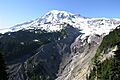
Mount Rainier and headwaters of the river from the Nisqually Glacier
-
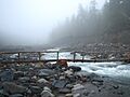
The upper Nisqually River in Mount Rainier National Park
-
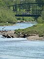
I-5 crosses the Nisqually River near its mouth


