Kautz Creek facts for kids
Quick facts for kids Kautz Creek |
|
|---|---|

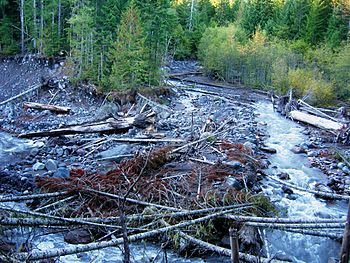
Kautz Creek in Mount Rainier National Park, photographed in 2006.
|
|
| Country | United States |
| State | Washington |
| National parks | Mount Rainier National Park |
| Physical characteristics | |
| Main source | Kautz Glacier, Mount Rainier |
| River mouth | Nisqually River |
| Length | 6 mi (9.7 km) |
| Basin features | |
| Tributaries |
|
Kautz Creek is a stream that flows from the Kautz Glacier on Mount Rainier in Mount Rainier National Park, Washington. It's like a smaller river that joins a bigger one, called the Nisqually River. Kautz Creek flows southwest from Mount Rainier for about 6 miles (9.7 km) before it meets the Nisqually River. You can find where it joins near the Mount Rainier Highway.
This creek is famous for its powerful floods. These floods happen because of a lot of melting ice from the glacier in summer. The creek's path often changes because of these floods. There's also a cool 400-foot (120 m) waterfall called Kautz Creek Falls. This waterfall formed as the Kautz Glacier slowly moved back over the last 50 years. The creek was named after A. V. Kautz, who was an army officer and a mountain climber.
How Kautz Creek Flows
The path of Kautz Creek is very steep and narrow. This is because the water has cut through soft ground. This ground was left behind by past mudflows and landslides. The creek flows in a deep ditch. This ditch is about 100 to 200 feet (30 to 61 m) wide and up to 75 feet (23 m) deep. During big floods, the creek's path often shifts and changes.
Powerful Mudflows and Floods
Kautz Creek is well-known for its history of big floods and mudflows. A mudflow is like a very thick, fast-moving river of mud, rocks, and water.
One of the biggest floods happened on October 2 and 3, 1947. Heavy rains caused a huge rush of water and mud from the Kautz Glacier. This type of flood, called a jökulhlaup, is a sudden release of water from a glacier. It was the largest flood since Mount Rainier National Park was created.
This flood was similar to a volcanic lahar, which is a destructive mudflow. It moved a massive amount of earth and boulders. Imagine 40,000,000 cubic metres (1.4×10⁹ cu ft) of dirt and rocks, with some boulders as big as 13 feet (4.0 m) across! This giant mudflow traveled for 6 miles (9.7 km). It buried the Nisqually-Longmire Road under 30 feet (9.1 m) of mud and rocks. It also carved a new canyon that was 300 feet (91 m) deep.
Other large mudflows have happened in the Kautz Creek area. These include events in 1961, 1985, and 1986. Smaller mudflows happen even more often. In November 2006, the creek overflowed its banks again. This destroyed parts of the Kautz Creek Trail.
 | Aurelia Browder |
 | Nannie Helen Burroughs |
 | Michelle Alexander |

