Thurston County, Washington facts for kids
Quick facts for kids
Thurston County
|
||
|---|---|---|

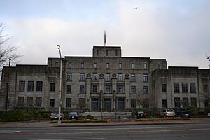
Former Thurston County Courthouse
|
||
|
||

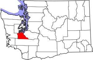
Location within the U.S. state of Washington
|
||
 Washington's location within the U.S. |
||
| Country | ||
| State | ||
| Founded | January 12, 1852 | |
| Named for | Samuel Thurston | |
| Seat | Olympia | |
| Largest city | Lacey | |
| Area | ||
| • Total | 774 sq mi (2,000 km2) | |
| • Land | 722 sq mi (1,870 km2) | |
| • Water | 52 sq mi (130 km2) 6.7%% | |
| Population
(2020)
|
||
| • Total | 294,793 | |
| • Estimate
(2023)
|
299,003 |
|
| • Density | 408/sq mi (158/km2) | |
| Time zone | UTC−8 (Pacific) | |
| • Summer (DST) | UTC−7 (PDT) | |
| Congressional districts | 3rd, 10th | |
Thurston County is a county located in the state of Washington. In 2020, about 294,793 people lived here. The main city, also called the county capital, is Olympia. Olympia is also the state capital of Washington.
Thurston County was created on January 12, 1852. It was formed from a larger area called Lewis County by the government of Oregon Territory. At first, it covered a huge area, including the entire Puget Sound region and the Olympic Peninsula. Later that same year, on December 22, several other counties were created from Thurston County. These included Pierce, King, Island, and Jefferson counties. The county is named after Samuel R. Thurston. He was the first person to represent the Oregon Territory in the U.S. Congress.
Thurston County is part of the Olympia–Tumwater, WA Metropolitan Statistical Area. This means it's a major city area. It's also included in the larger Seattle–Tacoma, WA Combined Statistical Area.
Contents
History of Thurston County
The southern part of Puget Sound has always been home to several Native American groups. These include the Nisqually, Squaxin, and Upper Chehalis people. Scientists have found old remains at Tumwater Falls that are 2,500 to 3,000 years old. This area was once a settlement with several longhouses, which are large traditional homes.
Early European Exploration and Settlement
The first Europeans to explore the southern Puget Sound were Peter Puget and Joseph Whidbey. They were part of the British Vancouver Expedition in May 1792. Later, the Hudson's Bay Company set up a trading post called Fort Nisqually in 1833. This was on the east side of the Nisqually Delta. At this time, the Oregon Country was shared by both British and American governments.
Permanent European settlers arrived in what is now Thurston County in 1845. A group of pioneers led by Michael Simmons and George Bush came to the area. Several families settled near Tumwater Falls. They called their new home "New Market." This became the first European settlement in Western Washington.
How Thurston County Was Formed
The area north of the Columbia River was first part of the Vancouver District. This was later renamed Clark County. In 1845, Lewis County was created from this area. The entire region became part of the United States after the Oregon Treaty was signed in 1846. Two years later, it became the Oregon Territory.
In December 1851, 54 people from Olympia asked the Oregon Territorial Legislature to create a new county. They wanted to name it Simmons County, after Michael Simmons. However, the legislature changed the name to Thurston County. This was suggested by Asa Lovejoy to honor Samuel Thurston, the first delegate to the U.S. Congress from Oregon Territory. Interestingly, Samuel Thurston had never actually visited the area.
Thurston County was officially created on January 12, 1852. Olympia was chosen as its main city. At first, it included the entire Olympic Peninsula and Puget Sound region. It stretched north to the border with British North America and east to the Cascade Mountains.
Changes to County Borders
On December 22, 1852, the northern parts of Thurston County were divided. This created Island, Jefferson, King, and Pierce counties. In February 1853, a part of Thurston County south of the Chehalis River was given to Lewis County. This happened a month before Washington Territory was created with Olympia as its capital.
Later, in March 1854, Sawamish County (now Mason County) was formed from the northwestern parts of Thurston County. A month after that, Chehalis County (now Grays Harbor County) was created from the western half. Over the 1860s, there were several small land changes between Thurston and its neighbors. The county's borders became what they are today by 1873. In 1861, voters decided not to move the county seat from Olympia to Tumwater or West Olympia.
Growth and Development
Olympia remained the capital of Washington when it became a state in 1889. Local people built a train line to connect with the Northern Pacific Railroad. They also approved a project to make the harbor deeper. This was to help Olympia become a bigger trade center.
The 150-foot (46 m) tall Thurston County Courthouse was finished in 1892. The state government bought it in 1901 to use as the state capitol building. The modern Washington State Capitol started being built in 1923 and was finished in 1928. It included many government buildings and monuments.
Thurston County mostly relied on the logging industry for a long time. But in the 1950s, the state government became the county's biggest employer. Some state agencies tried to move their offices to Seattle. However, in 1954, the Washington Supreme Court ruled that their main offices had to stay in the Olympia area.
Modern Changes
The first part of Interstate 5 in Thurston County opened in December 1958. This was the 6.5-mile (10.5 km) Olympia Freeway, which helped cars bypass the city's downtown. Other parts of the freeway opened over the next ten years. It extended through Lacey and Tumwater. Building it destroyed parts of the historic downtown in Tumwater.
Interstate 5 helped "bedroom communities" grow around Thurston County. These are places where people live but often work in a bigger city nearby. The county's population grew very fast from the 1950s to the 1970s. The first suburban shopping center, the South Sound Center in Lacey, opened in October 1966. Lacey became a city soon after. The Evergreen State College, a public college in western Olympia, opened in 1972.
Geography of Thurston County
Thurston County covers a total area of 774 square miles (2,000 km2). About 722 square miles (1,870 km2) of this is land, and 52 square miles (130 km2) (6.7%) is water.
Neighboring Counties
- Pierce County – to the northeast
- Lewis County – to the south
- Grays Harbor County – to the west
- Mason County – to the north and northwest
Main Roads
Natural Features
Thurston County has many rivers, lakes, and other natural spots.
- Black River
- Budd Inlet
- Capitol Lake
- Capitol Peak
- Capitol State Forest
- Chehalis River
- Deschutes River
- Eld Inlet
- Henderson Inlet
- Lake Lawrence
- Long Lake
- Mima Mounds
- Nisqually River
- Puget Sound
- Skookumchuck River
- Summit Lake
- Totten Inlet
Protected Natural Areas
- Nisqually National Wildlife Refuge is a special place for wildlife.
Plants and Animals
The Golden Paintbrush flower grows in the county. This plant was listed as an endangered species in 1997. But thanks to conservation efforts, this 12 in (30 cm) tall prairie flower was removed from the list in 2023.
South Thurston County has several wildlife and land preserves. These include the Black River Habitat Management Area, the Glacial Heritage Preserve, and the Scatter Creek Wildlife Area.
People of Thurston County
| Historical population | |||
|---|---|---|---|
| Census | Pop. | %± | |
| 1860 | 1,507 | — | |
| 1870 | 2,246 | 49.0% | |
| 1880 | 3,270 | 45.6% | |
| 1890 | 9,675 | 195.9% | |
| 1900 | 9,927 | 2.6% | |
| 1910 | 17,581 | 77.1% | |
| 1920 | 22,366 | 27.2% | |
| 1930 | 31,351 | 40.2% | |
| 1940 | 37,285 | 18.9% | |
| 1950 | 44,884 | 20.4% | |
| 1960 | 55,049 | 22.6% | |
| 1970 | 76,894 | 39.7% | |
| 1980 | 124,264 | 61.6% | |
| 1990 | 161,238 | 29.8% | |
| 2000 | 207,355 | 28.6% | |
| 2010 | 252,264 | 21.7% | |
| 2020 | 294,793 | 16.9% | |
| 2023 (est.) | 299,003 | 18.5% | |
| U.S. Decennial Census 1790–1960 1900–1990 1990–2000 2010–2020 |
|||
Thurston County has the sixth-largest population among Washington's counties. It is also one of the fastest-growing counties in the state. From 2010 to 2020, the county became more diverse. The number of people who identify as Hispanic or Latino grew by 63.2%.
The county's largest city is Lacey, with over 60,000 people. Lacey's population grew larger than Olympia's in the early 2020s. The smallest town in Thurston County is Bucoda, with 620 residents. More than 145,000 people live in areas of the county that are not part of any city. These areas are mostly between Olympia and Lacey.
Thurston County is part of the Olympia–Lacey–Tumwater Metropolitan Statistical Area (MSA). This MSA was one of the fastest-growing in the U.S. in the 2010s. Its population increased by 2.24% each year. A 2024 study found that Thurston County had the highest number of middle class households among U.S. metropolitan areas. About 66% of households had adults earning about double the national average income. Thurston County is also part of the larger Seattle–Tacoma, WA Combined Statistical Area.
Population in 2020
In 2020, there were 294,793 people living in Thurston County. There were 115,397 households and 76,717 families. The population density was about 408.0 inhabitants per square mile (157.5/km2).
The racial makeup of the county was:
- 73.2% White
- 3.2% African American
- 1.5% Native American
- 5.9% Asian
- 1.1% Pacific Islander
- 3.5% from other races
- 11.6% from two or more races
Hispanic or Latino people made up 9.8% of the population. About 20.5% of residents were under 18 years old. Also, 5.1% were under 5 years old, and 19.3% were 65 or older.
Education in Thurston County
Many school districts provide education for students from kindergarten to 12th grade in Thurston County. Some of these districts also cover parts of other counties.
- Centralia School District
- Griffin School District
- North Thurston Public Schools
- Olympia School District
- Rainier School District
- Rochester School District
- Tenino School District
- Tumwater School District
- Yelm Community Schools
Thurston County also has three colleges and universities:
- Evergreen State College
- Saint Martin's University
- South Puget Sound Community College
Parks and Fun Activities
The county has several rail trails. These are paths made from old railroad lines. The Chehalis Western Trail is the longest in the county. Other trails include the Karen Fraser Woodland Trail and the Yelm-Rainier-Tenino Trail. These are great for walking, biking, and enjoying nature.
Culture in Thurston County
Arts and Music Scene
Olympia was a very important place for indie music in the late 1900s. Many grunge, punk, and indie rock bands started there in the 1980s and 1990s. The indie record label K Records and the Evergreen State College's radio station KAOS helped many groups become famous. Both were started by musician Calvin Johnson.
Local News and Media
The main newspaper for Thurston County is The Olympian. It is based in Olympia and owned by the McClatchy Company. It prints three times a week. The Olympian started in 1891. It later joined with other local newspapers to become the only daily paper in the county.
Other newspapers in the past included The Columbian, started in 1852, and The Washington Standard, published weekly from 1860 to 1921. Because Olympia is the state capital, it used to have many news offices from newspapers across the state. By 2021, most of these offices had fewer reporters.
The county also has several weekly and online news publications. The Nisqually Valley News is published weekly in Yelm. The Tenino Independent has been published weekly since 1922. The Journal of Olympia, Lacey & Tumwater (JOLT) is an online news group that started in 2020.
Libraries for Everyone
Thurston County is part of the Timberland Regional Library system. This public library system serves five counties in southwestern Washington. Its main office is in Tumwater. Thurston County has seven library locations and a special bookmobile service.
Thurston County helped start the Timberland system. It began as a test project in 1964 and became a permanent library district in 1968. The oldest public library in the county opened in 1896. It was started by the Woman's Club of Olympia. They gave their collection of 900 books to the city in 1909. A permanent Carnegie library in Olympia opened in 1914. It had 1,500 books and was used until a new library building opened in 1978.
County Infrastructure
Getting Around: Transportation
Interstate 5 is a major highway that goes through Thurston County. It runs north and south along the U.S. West Coast. This highway connects Washington, Oregon, and California. It passes through Grand Mound, Tumwater, Olympia, and Lacey. It continues south to Portland, Oregon, and north to Tacoma and Seattle. Interstate 5 was built in the 1950s and 1960s. It replaced U.S. Route 99, which was the original main north-south highway.
Several other highways cross Interstate 5 in Thurston County. These roads connect to other parts of Washington state. For example, U.S. Route 12 goes west from Grand Mound to Aberdeen. U.S. Route 101 goes around most of the Olympic Peninsula. It also connects to Aberdeen through State Route 8. State Route 510 travels along the Nisqually River to Yelm. There, it meets State Route 507.
Thurston County has two public transportation systems. Intercity Transit has 18 bus routes that serve Olympia, Lacey, Tumwater, and Yelm. They also have "The One," a fast bus service in Olympia and Lacey. Plus, there are express buses to Lakewood that connect to other transit systems. Since 2020, all Intercity Transit routes have been free to ride.
Rural Transit is another service for communities south of Olympia and Tumwater. It is also free and connects with Lewis County Transit in Centralia.
Train Travel
Amtrak offers passenger train service through Thurston County. Trains stop at Centennial Station in southern Lacey. This station opened in 1993 and is mostly run by volunteers. The Cascades train has daily trips to Seattle, Portland, and Vancouver. The Coast Starlight train runs daily between Seattle, Sacramento, the San Francisco Bay Area, and Los Angeles. These trains use tracks owned by the BNSF Railway, which mostly runs freight trains.
Airports
The county has one public airport, Olympia Regional Airport. It is owned by the Port of Olympia. This airport is used for small planes, business flights, air ambulances, and government use. It has two runways and a control tower. The Olympia airport was considered as a possible location for a new passenger airport. This new airport would help with crowding at Seattle–Tacoma International Airport.
Healthcare Services
Thurston County has two main hospitals with a total of about 500 beds. The largest is Providence St. Peter Hospital near Lacey. It has 390 beds and is run by Providence Health & Services. It started in Olympia in 1887 and moved to its current location in 1971.
The Capital Medical Center in Olympia has 107 beds. It is run by MultiCare Health since 2021. It also has an emergency room in Lacey. This hospital was built in 1985 to help with the need for more hospital beds in the South Puget Sound area.
Communities in Thurston County

Cities in Thurston County
Towns in Thurston County
Census-Designated Places
These are areas that are like towns but are not officially incorporated as cities.
Unincorporated Communities
These are smaller communities that are not part of any city or town.
- Boston Harbor
- Driftwood
- Delphi
- East Olympia
- Gate
- Indian Summer
- Kellys Corner
- Lake Lawrence
- Littlerock
- Maytown
- Mushroom Corner
- Offutt Lake
- Saint Clair
- Schneiders Prairie
- Skookumchuck
- South Bay
- Steamboat Island
- Vail
Ghost Towns
- Tono is a former town that is now abandoned.
See also
 In Spanish: Condado de Thurston (Washington) para niños
 | Georgia Louise Harris Brown |
 | Julian Abele |
 | Norma Merrick Sklarek |
 | William Sidney Pittman |


