
San Francisco Bay Area facts for kids
Quick facts for kids
San Francisco Bay Area
|
|
|---|---|
.jpg)  .jpg) .jpg)     Clockwise from top: The Golden Gate Bridge, Muir Woods National Monument, Napa Valley vineyards, Sather Tower at UC Berkeley with the Bay in the background, the Stanford University Oval, the Palo Alto Baylands Nature Preserve, downtown San Jose's skyline, and San Francisco Chinatown with the Bay Bridge in the background
|
|

Location of the Bay Area within California.
The nine-county Bay Area. Additional counties in the larger fourteen-county combined statistical area. |
|
| Country | United States |
| State | California |
| Subregions |
|
| Core cities | Oakland San Francisco San Jose |
| Other municipalities | |
| Area | |
| • Nine-county | 6,966 sq mi (18,040 km2) |
| • San Jose-San Francisco-Oakland, CA Combined Statistical Area | 10,191 sq mi (26,390 km2) |
| Highest elevation | 4,360 ft (1,330 m) |
| Lowest elevation | −13 ft (−4.0 m) |
| Population
(2020)
|
|
| • Nine-county | 7.76 million |
| • Nine-county density | 1,115/sq mi (431/km2) |
| • San Jose-San Francisco-Oakland, CA Combined Statistical Area | 9.71 million |
| • San Jose-San Francisco-Oakland, CA Combined Statistical Area density | 953/sq mi (368/km2) |
| Demonym(s) | Bay Arean |
| Time zone | UTC−08:00 (Pacific) |
| • Summer (DST) | UTC−07:00 (PDT) |
| Area codes | 408/669, 415/628, 510/341, 650, 707, 925 |
The San Francisco Bay Area, often called the Bay Area, is a busy region in Northern California. It surrounds the San Francisco, San Pablo, and Suisun Bay areas, which are where rivers meet the ocean.
The Bay Area is usually defined by nine counties that touch these bays: Alameda, Contra Costa, Marin, Napa, San Mateo, Santa Clara, Solano, Sonoma, and San Francisco. Sometimes, other nearby counties are also included.
About 7.75 million people live in the nine-county Bay Area. It has many cities, towns, and parks, all connected by a big transportation system. The larger area, which includes fourteen counties, is the second-biggest in California and the fifth-biggest in the United States, with 9.67 million people. The Bay Area is very diverse, with people from many different backgrounds.
Humans have lived in the Bay Area for a very long time, with evidence going back 8,000–10,000 years. In 1769, the Ohlone people lived here when Spanish explorers arrived. Later, the United States took control in 1846. The California Gold Rush brought many people, and San Francisco became an important port. A big earthquake in 1906 destroyed much of San Francisco, but the region quickly rebuilt. After World War II, the Bay Area became a center for finance and technology, making it a very rich area.
Even though it's a busy urban place, the San Francisco Bay is very important for nature. It helps filter pollution and is home to many endangered species. The area also has beautiful coast redwoods. The land here is complex because of millions of years of tectonic plate movements. The Bay Area has six major earthquake faults, so big earthquakes are a risk. The weather is usually mild and great for outdoor activities like hiking and cycling. The Bay Area also has five professional sports teams and many universities, like Stanford University and the University of California, Berkeley.
Contents
Sub-regions
.svg)
East Bay

The eastern side of the bay, including Alameda and Contra Costa counties, is called the East Bay. It has two main parts:
- The inner East Bay is closer to the bay. It includes cities like Oakland, Hayward, Fremont, Berkeley, and Richmond. This area is more crowded, with older buildings, and a very diverse population. It has the Bay Area's largest seaport, the Port of Oakland, and the headquarters of Pixar Animation Studios.
- The outer East Bay is further inland. It includes areas like Lamorinda (Lafayette, Moraga, Orinda), Central Contra Costa County (Walnut Creek, Concord), East Contra Costa County (Antioch, Pittsburg), and the Tri-Valley (Dublin, Pleasanton, Livermore, San Ramon). This area grew a lot after World War II and is connected to the inner East Bay by BART and highways.
North Bay

The area north of the Golden Gate Bridge is known as the North Bay. This includes Marin County, Sonoma County, Napa County, and parts of Solano County. The city of Fairfield is often seen as the easternmost city here.
Marin County is one of the wealthiest areas in California. The North Bay is more rural than other parts of the Bay Area, with lots of open space, farms, and vineyards. Santa Rosa is the largest city in the North Bay. This region is separated from the rest of the Bay Area by water, with bridges like the Golden Gate Bridge and Richmond-San Rafael Bridge connecting it.
Peninsula

The area from San Francisco down to Silicon Valley is called The Peninsula. This includes San Francisco and towns in San Mateo County, plus the northwestern part of Santa Clara County. It also has coastal towns like Pacifica and Half Moon Bay.
This area is very diverse. Many towns here grew quickly after World War II as more people moved in. Since the 1980s, cities like Palo Alto, Los Altos, and Woodside have seen a lot of growth due to the technology boom in Silicon Valley. Many new residents are from other countries, adding to the diversity.
While "peninsula" technically means the whole San Francisco Peninsula, locally, "The Peninsula" usually refers to the areas south of San Francisco city.

San Francisco itself is surrounded by water on three sides. It's a very crowded city, with about 870,000 people living in a small area. This makes it the second most densely populated major city in North America, after New York City. Because there's not much land, housing prices are very high.
South Bay

The southern part of the Bay Area is mostly known as Silicon Valley, or the Santa Clara Valley. This includes San Jose and nearby cities like Santa Clara, Milpitas, Cupertino, Mountain View, and Sunnyvale.
Before World War II, Silicon Valley was mostly farmland. After the war, it grew rapidly as technology companies moved in. Today, it's a major tech center, home to companies like AMD, Adobe, Intel, Netflix, Apple, Google, and Facebook. Because of the tech industry, the San Jose area has many millionaires and billionaires.
San Jose is the largest city in the Bay Area and the tenth most populous city in the United States. It's also the oldest city in California and was its first capital. San Jose is known for being environmentally friendly, recycling a lot of its waste. The city has grown a lot, but it tries to control growth to protect open spaces.
San Jose is home to professional sports teams like the San Jose Sharks (hockey) and the San Jose Earthquakes (soccer). The San Francisco 49ers football team moved to a new stadium in Santa Clara in 2014. The South Bay has a large transportation system, including freeways, buses, light rail, and the San Jose International Airport.
Outer Bay
Whether Santa Cruz, San Benito, and San Joaquin counties are part of the Bay Area depends on who you ask. Some groups that manage the Bay Area only include the nine core counties. However, the U.S. government includes these three counties in its larger definition of the Bay Area.
Santa Cruz and San Benito counties are often seen as part of the California Central Coast, while San Joaquin County is usually part of the California Central Valley. However, these areas are closely connected to the Bay Area through jobs and history. San Joaquin County has grown as some of its cities have become places where people live and commute to the Bay Area for work.
History
Demographics
| Historical population | |||
|---|---|---|---|
| Census | Pop. | %± | |
| 1860 | 114,074 | — | |
| 1870 | 265,808 | 133.0% | |
| 1880 | 422,128 | 58.8% | |
| 1890 | 547,618 | 29.7% | |
| 1900 | 658,111 | 20.2% | |
| 1910 | 925,708 | 40.7% | |
| 1920 | 1,182,911 | 27.8% | |
| 1930 | 1,578,009 | 33.4% | |
| 1940 | 1,734,308 | 9.9% | |
| 1950 | 2,681,322 | 54.6% | |
| 1960 | 3,638,939 | 35.7% | |
| 1970 | 4,628,199 | 27.2% | |
| 1980 | 5,179,784 | 11.9% | |
| 1990 | 6,023,577 | 16.3% | |
| 2000 | 6,783,760 | 12.6% | |
| 2010 | 7,150,739 | 5.4% | |
| 2020 | 7,765,640 | 8.6% | |
| Note: Nine-County Population Totals | |||

.png)

In 2010, the nine-county Bay Area had about 7.15 million people. About 32% of them were born in other countries. The population is very diverse, with many different racial and ethnic groups.
Cities like Vallejo, Suisun City, Oakland, and Richmond are among the most diverse in the United States.
White residents are the majority in Marin, Napa, and Sonoma counties, and in parts of the East Bay. The Latino population is spread throughout the Bay Area, with the largest numbers in Santa Clara County. Many people of Salvadoran and Guatemalan descent live in San Francisco's Mission District.
The Asian-American population is one of the largest in the U.S. They make up a large part of the population in Santa Clara and Alameda counties. Large groups include people of Chinese, Filipino, Indian, and Vietnamese heritage. Daly City has a very high percentage of Asian-American residents. San Jose has the largest Vietnamese population of any city outside of Vietnam.
The African-American population has largely moved from San Francisco to parts of the East Bay and North Bay, such as Antioch and Fairfield.
Because the Bay Area's economy relies on technology, many residents have advanced education. About 87.4% have a high school degree, and 46% have a college degree or higher.
The Bay Area is one of the wealthiest regions in the United States, thanks to the strong economies of San Jose, San Francisco, and Oakland. However, the high cost of living, especially for housing, means that many people, even those with good incomes, find it expensive to live here. There's a big gap between the richest and poorest residents.
Climate


The Bay Area has a mild and generally pleasant climate. Temperatures usually stay moderate throughout the year. Summers are warm and dry, while winters are mild and wet. The weather is great for outdoor activities.
Ecology

Even with all the cities and industries, the San Francisco and San Pablo Bays are very important for nature in California. Many fish, like Dungeness crab and salmon, use the bay as a place to grow up. The remaining salt marshes are crucial habitats for many endangered species and help clean the water.
The bay is also a key stop for millions of waterfowl (birds that live near water) along the Pacific Flyway. Two endangered bird species, the California least tern and the California clapper rail, live here.
The water temperature in the Bay ranges from about 8°C (46°F) to 23°C (73°F). Pollution, like mercury from old industrial uses, can be a problem in the bay. In 2007, an oil spill from a ship caused a lot of damage to the environment.
Salmonids in the Bay Area
Steelhead (Oncorhynchus mykiss) and coho salmon (Oncorhynchus kisutch) populations have decreased a lot in California. These fish are important, and efforts are being made to protect them. For example, in places like Lagunitas Creek, people are working to restore wetlands and add wood to the creeks to help salmon find shelter.
Much of the Don Edwards San Francisco Bay National Wildlife Refuge is made of salt ponds. These ponds are still used to produce salt, but they also provide food for waterfowl, like brine shrimp. Some of these ponds are being restored to natural wetlands to help the environment.
Aquatic mammals in the Bay Area


Some water mammals have recently returned to the Bay Area. These include the California golden beaver and the North American river otter. Sea otters used to live in the bay but were hunted until they disappeared around 1817.
Sometimes, large whales like Humphrey the Whale, a humpback whale, have accidentally entered the bay. They were safely guided back to the ocean. Recently, Bottlenose dolphins and harbor porpoises have also returned to the bay after being absent for about 50 years. This is a good sign that the bay's water quality has improved.
Birds of the Bay Area

Western burrowing owls are a special concern in California because their numbers have dropped a lot. They need flat, grassy areas to live, but these areas are often developed for buildings. There are very few breeding burrowing owls left in some Bay Area counties. Efforts to protect them are ongoing, but it's challenging when their habitats are lost.
In 2012, a bald eagle nest was seen on the San Francisco Peninsula for the first time in almost 100 years. Bald eagles were once common here but disappeared due to habitat loss and pollution. Now, they are slowly returning.
Osprey birds, which were once rare visitors, are now nesting in more places around the Bay Area, even in urban spots. They often build nests on man-made structures. The wild turkey population has also grown a lot since they were introduced in the 1960s and 70s.
Geology and landforms

Multiple Terranes
The Bay Area's land is very complex. It's made up of at least six different types of land pieces (called terranes) that have been pushed together over millions of years by plate tectonics. This means you can find many different kinds of rocks and soils here, including sandstone, limestone, serpentine, and even signs of old volcanoes.
Vertical Relief
The region has many hills and mountains, not just flat plains. This has made it difficult to build cities and connect different areas. It costs a lot to build roads, tunnels, and bridges across the varied landscape.


Several mountains offer amazing views of the Bay Area. These include Mount Tamalpais in Marin County, Mount Diablo in Contra Costa County, and Mount Hamilton in Santa Clara County, which has the famous Lick Observatory. These mountains are part of large ridge systems that run parallel to the major earthquake faults.
Major Waterways
The Bay Area has many important rivers and creeks that flow into the bay, including the San Joaquin River, Sacramento River, and Napa River. These waterways are vital for the region's ecology and water supply.
Earthquake Faults
The Bay Area is crossed by six major earthquake fault systems, plus hundreds of smaller ones. These faults are under stress because of the movement of the Pacific Plate and the North American Plate. The most famous is the San Andreas Fault, but others include the Hayward Fault Zone and Calaveras Fault.
Natural hazards
Earthquakes

The Bay Area faces a high risk from large earthquakes. Two major ones were the 1906 San Francisco earthquake and the 1989 Loma Prieta Earthquake. The risk is high because:
- There are many active faults in the region.
- There's a high chance of a major earthquake in the next 30 years.
- Some soils, especially near the bay, can make shaking worse.
- Many areas built on old marshlands can turn to liquid during an earthquake (called soil liquefaction).
- Many older buildings might not hold up well in a big earthquake.
- Some areas are built on landslide-prone ground or directly over fault lines.
- Fires can spread quickly after an earthquake if water systems are damaged.
- The coastal location means there's a risk of tsunamis from the Pacific Ocean.
To make the area safer, buildings are being strengthened, and people are learning about earthquake safety. For example, the eastern part of the San Francisco–Oakland Bay Bridge was completely rebuilt to be more earthquake-resistant.
Flooding
Sometimes, local areas can flood when there's a lot of rain and the ground gets soaked. This happens more often in the North Bay. In some places, old river channels are being restored to natural wetlands to help prevent flooding.
Windstorms and Wildfires
From late November to early March, strong Pacific storms can bring heavy rain and strong winds. These winds can knock down trees and power lines, causing electricity outages.
In spring and fall, strong winds called Diablo winds can blow from inland. These winds are very dangerous for wildfires, especially in the fall when plants are very dry. Famous fires like the 1991 Oakland Firestorm were made worse by these winds.
Mudslides and Landslides
Some areas built on unstable ground can have mudslides or landslides, especially after heavy rains or if the land has been changed for development. These are usually small, but larger ones have happened in the Santa Cruz Mountains.
Transportation

Getting around the San Francisco Bay Area involves a big system of roads, bridges, highways, trains, tunnels, airports, and ferries. Many different groups work together to manage all this transportation.
The Bay Area has a large network of freeways and highways, but they often get very crowded. Some parts of the freeway system in San Francisco are missing because people protested against building more highways through the city. After the 1989 earthquake, some damaged freeway sections were removed instead of rebuilt, which helped improve neighborhoods like the Embarcadero.
There are over two dozen public transit agencies in the Bay Area. The Bay Area Rapid Transit (BART) is a train system that connects five counties, including San Francisco and Oakland with an underwater tunnel. Other train systems like Caltrain and ACE connect different parts of the region. Amtrak also provides train service.
Within San Francisco, Muni Metro runs a system of streetcars and subways. In Santa Clara County, VTA operates a light rail system. Buses and ferries also help people get around. Most of these systems use a special card called the Clipper Card for easy payment.
Culture
The Bay Area is a lively place with many cultural events, including annual festivals. Many famous writers live here, creating a strong local literary scene.
Art
Sports

| Team | Sport | League | Venue |
|---|---|---|---|
| San Jose Earthquakes | Soccer | Major League Soccer | Avaya Stadium |
| San Francisco 49ers | Football | National Football League – National Conference | Levi's Stadium |
| Oakland Raiders | Football | National Football League – American Conference | O.co Coliseum |
| San Francisco Giants | Baseball | Major League Baseball – National League | AT&T Park |
| Oakland Athletics | Baseball | Major League Baseball – American League | O.co Coliseum |
| Golden State Warriors | Basketball | National Basketball Association | Oracle Arena |
| San Jose Sharks | Ice hockey | National Hockey League | SAP Center at San Jose |
| San Francisco Nighthawks | Soccer | Women's Premier Soccer League | Kezar Stadium |
| San Jose Giants | Baseball | Minor League Baseball – California League | San Jose Municipal Stadium |
- NCAA Division I College Sports
- California Golden Bears
- Saint Mary's College Gaels
- San Francisco Dons
- San Jose State Spartans
- Santa Clara Broncos
- Stanford Cardinal
Motorsports
- Infineon Raceway in Sonoma hosts major car races like NASCAR Sprint Cup Series and IndyCar Series events.
Music
Classic Rock
San Francisco was a center for the hippie movement in the 1960s and its music. Bands like The Grateful Dead, Jefferson Airplane, and singer Janis Joplin were famous during the Summer of Love in 1967. Other bands like Creedence Clearwater Revival and Journey also came from the Bay Area.
Heavy Metal
In the 1980s and early 1990s, the Bay Area was a huge hub for thrash metal music. Famous bands like Metallica, Exodus, and Testament started or became big here. Many other metal bands also formed in the area.
Alternative Rock
Many popular post-grunge bands from the 1990s, like Third Eye Blind, Counting Crows, and Smash Mouth, came from the Bay Area. They had many hit songs played on the radio.
Punk
The Bay Area has a strong history of punk music. Bands such as the Dead Kennedys, Green Day, and Rancid were important in the punk scene from the 1970s to today.
Rap and Hip Hop
The Bay Area is known as the birthplace of the hyphy movement in hip hop, which started in the 1990s. Rappers like Andre "Mac Dre" Hicks, Too Short, and E-40 helped create this unique style. Famous rapper Tupac Shakur also lived in the Bay Area.
Media
The Bay Area is one of the biggest media markets in the United States. Major newspapers include the San Francisco Chronicle and the San Jose Mercury News. There are many local TV channels and radio stations serving the area.
Regional counties, cities, and suburbs

Counties
- Alameda County (737 sq. mi., excluding water)
- Contra Costa County (720 sq. mi., excluding water)
- Marin County (520 sq. mi., excluding water)
- Napa County (754 sq. mi., excluding water)
- San Francisco County (47 sq. mi., excluding water)
- San Mateo County (449 sq. mi., excluding water)
- Santa Clara County (1,291 sq. mi., excluding water)
- Solano County (829 sq. mi., excluding water)
- Sonoma County (1,576 sq. mi., excluding water)
Cities and towns
- List of cities and towns in the San Francisco Bay Area
Economy
.jpg)
The Bay Area's main cities each have different important industries. San Francisco is known for its financial industry, tourism, and conventions. The East Bay, especially Oakland, has heavy industry, metalworking, and shipping. San Jose is the center of Silicon Valley, famous for its technology industry. The North Bay is important for farming and wine.
The Bay Area has the second-highest number of Fortune 500 companies in the U.S., after New York City. Many major companies have their headquarters here, including tech giants like Google, Facebook, Apple Inc., Intel, and Oracle. Other big companies include Chevron (energy), Wells Fargo (finance), and Gap Inc. (clothing). The Port of Oakland is one of the largest shipping ports in the U.S.
Even with all this wealth, there is still poverty in the Bay Area. Housing prices have risen very quickly, making it hard for many people to afford to live here. This has led to some low-income neighborhoods becoming more expensive. Programs like rent control and housing assistance try to help.
Poverty is also growing in the suburban areas of the Bay Area, not just in the cities. This might be because people are moving to cheaper homes in the suburbs. People with lower incomes in the Bay Area often struggle with food and health because so much of their money goes to rent.
Sports and recreation


The Bay Area is home to six major professional sports teams:
- The San Francisco 49ers (football) play at Levi's Stadium and have won five Super Bowls.
- The San Francisco Giants (baseball) play at Oracle Park and have won eight World Series titles.
- The A's (baseball) play at the Oakland Coliseum and have won nine World Series titles.
- The Golden State Warriors (basketball) play at the Chase Center and have won five NBA Finals.
- The San Jose Sharks (ice hockey) play at the SAP Center.
- The San Jose Earthquakes (soccer) play at Avaya Stadium and have won the MLS Cup twice.
Besides major league teams, there are also minor league teams in hockey, baseball, and soccer.
For college sports, six Bay Area universities are in NCAA Division I, the highest level. The California Golden Bears and Stanford Cardinal are big rivals, especially in football, where they play for the Stanford Axe in the "Big Game".
The Bay Area's climate is perfect for outdoor activities like hiking, cycling, and jogging. San Francisco has many bike paths and public tennis courts. Boating, sailing, and windsurfing are popular on San Francisco Bay. The Bay Area also hosted the 2013 America's Cup sailing race.
Education
Colleges and Universities


The Bay Area has many colleges and universities. The most famous are Stanford University, University of California, Berkeley, and University of California, San Francisco. These are considered some of the best universities in the world.
The first college in the Bay Area, Santa Clara University, was founded in 1851. San Jose State University started in 1857 and is the oldest public college on the West Coast. Many Bay Area residents have college degrees, making it one of the most educated areas in the country.
U.S. News & World Report ranks Stanford as the highest in the Bay Area and seventh in the U.S. UC Berkeley is ranked twentieth overall and has been the top public university for many years.
San Francisco also has two other University of California schools: University of California, San Francisco (for health and science graduate studies) and University of California, Hastings College of the Law (the oldest law school in California). San Francisco State University is also in the city. Other California State University campuses are in Hayward and Vallejo.
The California Community Colleges System has many community colleges in the Bay Area. De Anza College in Cupertino is known for its high success rate.
Universities like Stanford and UC Berkeley are very important to the Bay Area's culture and economy. They offer many public programs and bring in a lot of money to the region.
Primary and Secondary Schools
Public schools in the Bay Area are run by school districts. There are also "special service schools" for students with special needs and charter schools, which are public schools run by other groups.
According to U.S. News & World Report, the highest-ranked high school in California is Pacific Collegiate School in Santa Cruz. Within the nine-county Bay Area, KIPP San Jose Collegiate in San Jose is highly ranked. Other top high schools include Lowell High School in San Francisco and Monta Vista High School in Cupertino.
Images for kids
-
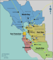
A map of the locally accepted nine-county definition of the Bay Area. Also displayed are the five subregions of the Bay Area, which are divided along county lines except for the northwestern portion of Santa Clara county.
-
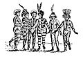
An early sketch of the Ohlone people dancing in Mission San Jose. The Ohlone lived in the Bay Area when European colonizers first arrived in the region.
-
The Bay Area, like all of California, was a part of Mexico until 1846, when John Berrien Montgomery captured San Francisco during the Mexican–American War and raised the American flag over Portsmouth Square.
-
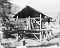
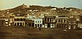
Discovery of gold near Sutter's Mill transformed the Bay Area, which saw a flood of immigrants seeking wealth and hoping to strike it rich.
-
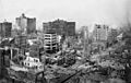
Damaged buildings in the aftermath of the 1906 San Francisco earthquake
-
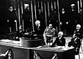
U.S. President Harry S. Truman addressing the United Nations Conference in San Francisco that established the United Nations.
-
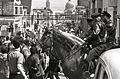
Mounted policeman observe a protest march against the Vietnam War in San Francisco in 1967.
-
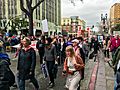
2017 Women's March in Oakland. Other political rallies were held on the same day in numerous other locations throughout the Bay Area to spotlight progressive political causes and oppose Trump's presidency.
-
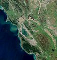
Satellite photo of the Bay Area taken in March 2019. The gray areas are signs of urbanization and represent the most populated areas.
-
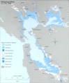
A map of the water features in the San Francisco Bay Area, including the bay and adjacent marshes, ponds, and tributaries
-
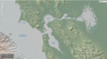
NOAA Bathymetry Image of San Francisco Bay Area (2020)
-
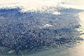
Dense Infrastructure in Downtown San Francisco
-
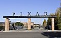
Pixar, whose animated films have won numerous Academy Awards, is based in Emeryville.
-
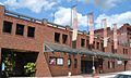
The Berkeley Repertory Theatre is one of the founding members of Theatre Bay Area and is based in a building (pictured above) in downtown Berkeley.
-
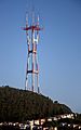
Sutro Tower, the landmark TV and radio antenna tower in San Francisco where some of the major Bay Area stations transmit from


.jpg)
.jpg)

.png)


See also
 In Spanish: Área de la Bahía de San Francisco para niños
