
San Bruno Mountain facts for kids
Quick facts for kids San Bruno Mountain |
|
|---|---|

Aerial view from the south of South San Francisco, San Bruno Mountain, and San Francisco
|
|
| Highest point | |
| Elevation | 1,319 ft (402 m) NAVD 88 |
| Prominence | 1,114 ft (340 m) |
| Geography | |

San Bruno Mountain
Location in San Francisco

San Bruno Mountain
Location in San Francisco Bay Area

San Bruno Mountain
Location in California
|
|
| Location | San Mateo County, California, U.S. |
| Parent range | Santa Cruz Mountains |
| Topo map | USGS San Francisco South |
| Climbing | |
| Easiest route | Trail hike |

San Bruno Mountain is a special place in northern San Mateo County, California. Some parts of the mountain even reach into southern San Francisco. Most of this mountain is protected within the San Bruno Mountain State Park, which is about 2,326 acres big. Right next to it, there's also an 83-acre San Bruno Mountain Ecological Reserve on the north side.
The mountain is located near the southern edge of San Francisco. It is surrounded by several cities. These include South San Francisco, Daly City, Colma, and Brisbane.
San Bruno Mountain has a long ridge at its top, stretching for four miles. If you hike to the summit, you can see amazing views of the whole San Francisco Bay Area. The highest point is called Radio Peak, standing at 1,319 feet tall. This peak is home to many radio and TV towers. These towers help broadcast signals for stations like KTSF, ION's KKPX, and NBC's KNTV. They serve a huge area where signals might otherwise be weak because of all the hills.
This mountain is also a very important home for many rare and endangered plants and butterflies. For example, the endangered San Bruno elfin butterfly lives here and in only a few other spots. The unique plants found on San Bruno Mountain are special. They are different from those in other coastal areas of California. This is because of the mountain's special "Franciscan fog zone" climate.
Contents
Mountain History: Discovering San Bruno
The first Europeans to visit the San Francisco Bay area were part of the Portolá expedition in 1769. Five years later, in 1774, a person named Fernando Rivera and four soldiers climbed this mountain. They watched the beautiful sunrise over the bay. The mountain was later named by Bruno de Heceta in honor of his patron saint.
Over time, San Bruno Mountain became part of large land areas called Mexican land grants. One of these was Rancho Buri Buri, given to José de la Cruz Sánchez in 1827. Another important one was Rancho Canada de Guadalupe la Visitacion y Rodeo Viejo. This rancho covered most of what is now San Bruno Mountain. In 1884, a banker named Charles Crocker bought a large part of this land. Today, the Crocker Estate Company still owns much of San Bruno Mountain.
The cities that grew up around the mountain are San Francisco to the north, Brisbane to the east, South San Francisco to the south, and both Daly City and Colma to the west.
Television stations started putting their towers on Radio Peak in 1949. KRON (Channel 4) was the first. Later, other stations like KQED and KTVU also built towers there. Some of these stations later moved their transmitters to Sutro Tower in the 1970s. In 2005, KNTV moved its transmitter to the mountain. KTSF now uses the old KRON site.
Building Around the Mountain: The Terra Bay Project
.jpg)
The Terra Bay project was a big construction plan. It was approved in the mid-1980s. The project built homes and offices at the base of San Bruno Mountain. It was built in three main parts. The first two parts created many homes, including a tall condominium building called the Peninsula Mandalay. The third part built an office building called Centennial Towers.
The area where Terra Bay was built was known to be a home for rare butterflies. These included the Mission blue and Callippe silverspot butterflies. In 1983, the original company building the project was fined for damaging some of this butterfly habitat.
.jpg)
There was also an ancient shellmound on the site. This shellmound was a pile of shells and other items left by early people. It was discovered to contain human remains and was important historically. After some discussions, the land with the shellmound and butterfly habitat was sold. It became part of the San Bruno Mountain State Park. This helped protect these important historical and natural areas.
Mountain Features: Shape, Rocks, and Weather

The name "San Bruno Mountains" was first used in 1865. It described a short mountain range stretching from Sierra Point almost to the Pacific Ocean.
The mountain actually has two parallel ranges. These ranges are separated by the Guadalupe Valley. They are connected by a lower area at the northern end of Colma Canyon. The northern range reaches about 850 feet high. The southern range rises sharply from Merced Valley to Radio Peak. This southern range is often called San Bruno Mountain. The northern range is known as the Crocker Hills.
Two main streams drain the area. Guadalupe Valley Creek flows through Guadalupe Valley. Colma Creek starts in San Bruno Mountain State and County Park. It flows into Colma Canyon and then into Merced Valley.
In the 1850s, the San Francisco Bay reached the eastern side of San Bruno Mountain. Today, the entire shoreline there is made of landfill.
The mountains are mostly made of a rock called graywacke. This is a dark, greenish-gray sandstone that formed a long time ago. You can see this rock on high ridges and steep canyon walls.
.jpg)
The most important rock here is serpentine. This is a soft, greenish rock and is California's State Rock. Serpentine is special because its unique minerals help rare plants grow. These plants cannot usually grow in common soils. This is why San Bruno Mountain is home to so many unusual plants. These plants, in turn, support even rarer animals, like the butterflies.
The weather on San Bruno Mountain is mostly influenced by the ocean. This means winters and summers are mild. In summer, cool marine fog often covers the mountains. This happens most mornings between late June and late August. It's especially noticeable on the western slopes.
Winds on the ridges are often very strong. During winter storms, gusts can reach 50 to 80 miles per hour. The mountain gets about 22 inches of rain each year. It rains on about 66 days a year. Sometimes, the mountain even gets a temporary covering of snow. This has happened several times, including in 1932, 1952, 1957, 1962, 1976, 2011, and 2019.

Special Plants of San Bruno Mountain
This mountainous area has many different types of natural homes, called habitats. It is especially known for several rare or endangered plants. These unique plants include:
- Coast rock cress (Arabis blepharophylla)
- Franciscan Wallflower (Erysimum franciscanum)
- Montara Manzanita (Arctostaphylos montaraensis)
- Pacifica Manzanita (Arctostaphylos pacifica)
- San Bruno Mountain Manzanita (Arctostaphylos imbricata)
- San Francisco Campion (Silene verecunda)
- San Francisco Owl's Clover (Orthocarpus floribundus)
Images for kids
-
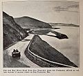
The Bayshore road passes the eastern foot of San Bruno Mountain (1915 or earlier)
-
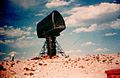
"LOPAR" (low-power IFF acquisition radar) for Nike Ajax.


