South San Francisco, California facts for kids
Quick facts for kids
South San Francisco
|
||
|---|---|---|
| City of South San Francisco | ||
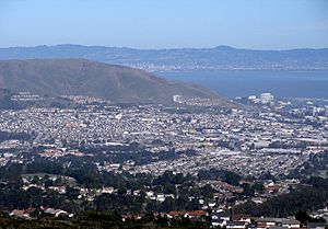
South San Francisco as viewed from a nearby ridge
|
||
|
||
| Nickname(s):
South City; The Industrial City; The Birthplace of Biotechnology
|
||
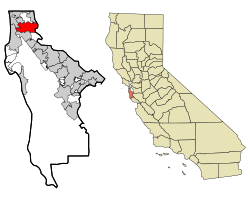
Location in San Mateo County and the state of California
|
||
| Country | United States | |
| State | California | |
| County | San Mateo | |
| CSA | San Jose–San Francisco–Oakland | |
| Metro | San Francisco–Oakland–Hayward | |
| Incorporated | September 19, 1908 | |
| Area | ||
| • City | 30.17 sq mi (78.15 km2) | |
| • Land | 9.20 sq mi (23.84 km2) | |
| • Water | 20.97 sq mi (54.32 km2) 69.69% | |
| Elevation | 16 ft (5 m) | |
| Population
(2020)
|
||
| • City | 66,105 | |
| • Density | 7,185.33/sq mi (2,772.86/km2) | |
| • Metro | 4,749,008 (13th) | |
| • CSA | 9,714,023 (5th) | |
| Demonym(s) | South San Franciscan | |
| Time zone | UTC−8 (Pacific Time Zone) | |
| • Summer (DST) | UTC−7 (PDT) | |
| ZIP Codes |
94080, 94083, 94099
|
|
| Area code(s) | 650 | |
| FIPS code | 06-73262 | |
| GNIS feature IDs | 277618, 2411942 | |
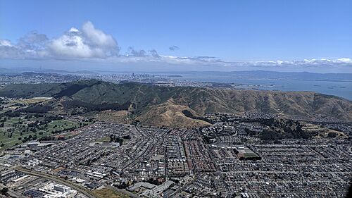
South San Francisco is a city in San Mateo County, California, United States. It is located on the San Francisco Peninsula in the San Francisco Bay Area. People have lived in this area for over 5,000 years. The city is often called "South City". In 2020, about 66,105 people lived there.
Contents
- A Look at South San Francisco's Past
- Where is South San Francisco?
- Who Lives in South San Francisco?
- What is the Economy Like?
- Arts and Culture
- Schools and Learning
- Fire Department
- Neighborhoods of South San Francisco
- Fun Things to Do and See
- Getting Around South San Francisco
- Famous People From South San Francisco
- Sister Cities
- See also
A Look at South San Francisco's Past
Before Europeans arrived, the northern San Francisco peninsula was home to the Ramaytush people. They were a group of the Ohlone people. Their village, Urebure, was visited by explorers in 1769. Signs of people living here for over 5,000 years have been found. These ancient sites were used even when the Spanish arrived in the late 1700s.
In 1835, the land that is now South San Francisco became part of Rancho Buri Buri. This was a large Mexican land grant given to the Sanchez family. They used it for raising cattle. Later, parts of this land were sold.
In 1853, a butcher named Charles Lux bought 1,700 acres of land. He partnered with Henry Miller to form a beef-raising company. Lux founded the town of Baden, which is now a part of South San Francisco. In 1863, Baden became a train station when the San Francisco and San Jose Railroad was built.
How South San Francisco Became an Industrial City
The idea for South San Francisco came from large meat-packing companies. They wanted to create a city just for industries. In 1888, Gustavus Franklin Swift, who started Swift & Company, planned the city. He wanted many meat-packing companies to share a large stockyard. There would also be homes for the workers. Swift named it South San Francisco, like other industrial cities he knew.
In 1891, the South San Francisco Land and Improvement Company took over the land. They divided it into areas for factories and homes. They also added lights, sewers, and water to the residential areas. A large meat-packing facility opened in 1892. Soon, other businesses moved in, like pottery works, brick companies, and steel companies.
The city officially became a city in 1908. This happened after a disagreement with San Mateo County. The county had stopped a factory from being built, but locals wanted it. After becoming a city, more industries came. A new City Hall opened in 1920.
By the 1920s, South San Francisco was known as "the smokestack capital of the Peninsula." In 1923, a huge sign on a hillside proudly called it "The Industrial City." Factories were the main focus until the 1950s. Even during the Great Depression, the city had 35 factories. These included meat-packing, steel, and chemical plants. During World War II, shipbuilding also became very important. A total of 48 ships were built here.
After the war, the city changed. It moved away from heavy industries. New developments focused on offices, homes, and hotels. In 1976, Genentech, a big biotechnology company, opened. This led to South San Francisco being called "the birthplace of biotechnology." The population grew to 63,632 by 2010.
Where is South San Francisco?
South San Francisco covers about 30.2 square miles (78.15 square kilometers). Most of this area, about 21.0 square miles (54.32 square kilometers), is water. The land area is about 9.1 square miles (23.84 square kilometers).
The city is north of San Bruno and the San Francisco International Airport. It is south of Daly City, Colma, and Brisbane. To the east is the San Francisco Bay. To the west are the hills of the Santa Cruz Mountains. Locals often call the city "South City." South San Francisco does not directly touch the city of San Francisco. Other cities are in between them.
Most of the city faces east towards San Francisco Bay. This means many places have great bay views. South San Francisco has mild winters and cool, dry summers. The hills to the west help block some of the fog.
The city's population has grown a lot. It went from 4,411 people in 1920 to 67,009 in 2014. Many new neighborhoods were built, like Buri Buri and Winston Manor.
South San Francisco's Famous Sign Hill
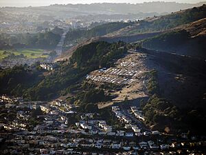
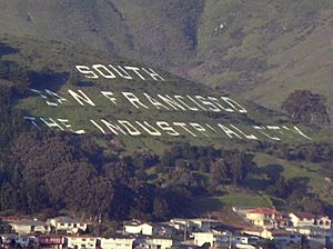
The city is famous for the South San Francisco hillside sign on Sign Hill. This hill is north of the city. It has huge white letters that say "South San Francisco, The Industrial City." The sign honors the city's industrial past. It is listed on the National Register of Historic Places.
Weather in South San Francisco
South San Francisco has a mild mediterranean climate. This means it has warm, dry summers and cool, wet winters. The wind from the nearby Pacific Ocean keeps temperatures cool all year. Even in summer, it's often cool during the day.
January is usually the coolest month. August is the warmest. The highest temperature ever recorded was 106°F (41°C) on June 14, 1961. The lowest was 24°F (-4°C) on December 9, 1972. The city gets about 19.64 inches (499 mm) of rain each year.
| Climate data for San Francisco International Airport (1991–2020 normals), extremes since 1945 | |||||||||||||
|---|---|---|---|---|---|---|---|---|---|---|---|---|---|
| Month | Jan | Feb | Mar | Apr | May | Jun | Jul | Aug | Sep | Oct | Nov | Dec | Year |
| Record high °F (°C) | 74 (23) |
78 (26) |
85 (29) |
92 (33) |
97 (36) |
106 (41) |
99 (37) |
99 (37) |
104 (40) |
99 (37) |
85 (29) |
75 (24) |
106 (41) |
| Mean maximum °F (°C) | 65 (18) |
70 (21) |
75 (24) |
81 (27) |
84 (29) |
89 (32) |
86 (30) |
87 (31) |
91 (33) |
87 (31) |
74 (23) |
65 (18) |
94 (34) |
| Mean daily maximum °F (°C) | 58.0 (14.4) |
60.8 (16.0) |
63.4 (17.4) |
65.6 (18.7) |
68.3 (20.2) |
71.5 (21.9) |
72.6 (22.6) |
73.4 (23.0) |
74.8 (23.8) |
72.3 (22.4) |
64.3 (17.9) |
58.2 (14.6) |
66.9 (19.4) |
| Daily mean °F (°C) | 51.3 (10.7) |
53.5 (11.9) |
55.5 (13.1) |
57.3 (14.1) |
59.9 (15.5) |
62.5 (16.9) |
64.0 (17.8) |
64.9 (18.3) |
65.3 (18.5) |
62.9 (17.2) |
56.4 (13.6) |
51.4 (10.8) |
58.7 (14.8) |
| Mean daily minimum °F (°C) | 44.5 (6.9) |
46.1 (7.8) |
47.6 (8.7) |
49.1 (9.5) |
51.6 (10.9) |
53.6 (12.0) |
55.3 (12.9) |
56.4 (13.6) |
55.9 (13.3) |
53.4 (11.9) |
48.5 (9.2) |
44.6 (7.0) |
50.6 (10.3) |
| Mean minimum °F (°C) | 37 (3) |
39 (4) |
41 (5) |
44 (7) |
48 (9) |
50 (10) |
52 (11) |
53 (12) |
52 (11) |
48 (9) |
41 (5) |
37 (3) |
36 (2) |
| Record low °F (°C) | 26 (−3) |
30 (−1) |
31 (−1) |
36 (2) |
39 (4) |
43 (6) |
44 (7) |
45 (7) |
41 (5) |
37 (3) |
31 (−1) |
24 (−4) |
24 (−4) |
| Average precipitation inches (mm) | 3.89 (99) |
3.96 (101) |
2.73 (69) |
1.36 (35) |
0.48 (12) |
0.14 (3.6) |
0.00 (0.00) |
0.04 (1.0) |
0.07 (1.8) |
0.79 (20) |
2.04 (52) |
4.14 (105) |
19.64 (499) |
| Average precipitation days (≥ 0.01 inch) | 11 | 11 | 10 | 6 | 3 | 1 | 0 | 0 | 1 | 3 | 7 | 11 | 65 |
| Source: NOAA | |||||||||||||
South San Francisco is often windy. Summer is the windiest season, with winds averaging 13.6 mph (21.9 km/h). Winter is the least windy, with winds averaging 7.5 mph (12.1 km/h).
| Month | Jan | Feb | Mar | Apr | May | Jun | Jul | Aug | Sept | Oct | Nov | Dec | Annual |
|---|---|---|---|---|---|---|---|---|---|---|---|---|---|
| Wind (mph) | 7.2 | 8.6 | 10.5 | 12.2 | 13.4 | 14.0 | 13.6 | 12.8 | 11.1 | 9.4 | 7.5 | 7.1 | 10.6 |
Who Lives in South San Francisco?
| Historical population | |||
|---|---|---|---|
| Census | Pop. | %± | |
| 1910 | 1,989 | — | |
| 1920 | 4,411 | 121.8% | |
| 1930 | 6,193 | 40.4% | |
| 1940 | 6,629 | 7.0% | |
| 1950 | 19,351 | 191.9% | |
| 1960 | 39,418 | 103.7% | |
| 1970 | 46,646 | 18.3% | |
| 1980 | 49,393 | 5.9% | |
| 1990 | 54,312 | 10.0% | |
| 2000 | 60,552 | 11.5% | |
| 2010 | 63,632 | 5.1% | |
| 2020 | 66,105 | 3.9% | |
| U.S. Decennial Census | |||
Population in 2010
In 2010, South San Francisco had a population of 63,632 people. The city had about 6,961 people per square mile (2,688 per square kilometer).
The population was made up of many different groups:
- 37.3% White
- 2.6% African American
- 0.6% Native American
- 36.6% Asian
- 1.7% Pacific Islander
- 15.1% from other races
- 6.1% from two or more races
About 34.0% of the people were Hispanic or Latino. This group included people from Mexico, Puerto Rico, Cuba, and other places.
Most people (99.1%) lived in homes. There were 20,938 households. About 36.2% of these households had children under 18. The average household had about 3 people.
The population was spread out by age:
- 21.7% were under 18
- 8.9% were 18 to 24
- 29.3% were 25 to 44
- 27.0% were 45 to 64
- 13.1% were 65 or older
The average age was 38.1 years.
| Demographic profile | 2010 |
|---|---|
| Total Population | 63,632 - 100.0% |
| One Race | 59,782 - 93.9% |
| Not Hispanic or Latino | 41,987 - 66.0% |
| Black or African American alone | 1,480 - 2.3% |
| American Indian and Alaska Native alone | 138 - 0.2% |
| Asian alone | 22,923 - 36.0% |
| Native Hawaiian and Other Pacific Islander alone | 1,054 - 1.7% |
| Some other race alone | 287 - 0.5% |
| Two or more races alone | 2,089 - 3.3% |
| Hispanic or Latino (of any race) | 21,645 - 34.0% |
| White (Non-Hispanic) | 16,226 - 25.5% |
What is the Economy Like?
South San Francisco does not charge certain business taxes. Instead, it gets most of its money from property, sales, and hotel taxes. The city wants to be known as a business-friendly place.
Long ago, much of South San Francisco was farmland. It was known as Baden. Some small farms still exist, but most land has become neighborhoods. For example, Acres of Orchids, a large flower nursery, closed in 1998. Now, homes stand where its greenhouses once were.
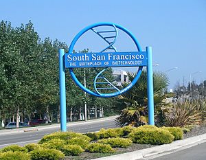
The flat land east of Highway 101 is a big area for research and development. South San Francisco is home to Genentech, one of the world's largest biotech companies. Amgen, another huge biotech firm, also has an office here. Many other biotech companies have moved to South San Francisco. They want to be close to major universities like UCSF and Stanford University. A sign on East Grand Avenue calls South San Francisco the "Birthplace of Biotechnology."
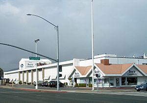
The main factory and headquarters for See's Candies are in South San Francisco. They moved here because of the cooler weather. Other companies like Air China and Sanrio (the company behind Hello Kitty) have also had offices here.
In 2019, Stripe, an online payment company, decided to move its headquarters here. They leased a very large office space.
Top Employers in South San Francisco
Here are the top employers in South San Francisco as of 2022:
| # | Employer | # of Employees |
|---|---|---|
| 1 | Genentech | 8,632 |
| 2 | AbbVie | 1,000 |
| 3 | Costco Wholesale | 834 |
| 4 | Life Technologies Corporation | 622 |
| 5 | Amgen | 600 |
| 6 | Verily Life Sciences | 555 |
| 7 | Amazon.com Services, Inc | 425 |
| 8 | ZS Associates, Inc. | 390 |
| 9 | MRL San Francisco LLC | 317 |
| 10 | Frank & Grossman Landscape Contractors | 265 |
Arts and Culture
The Linden Avenue Post Office has a special mural painted in the 1930s by Victor Arnautoff. The Grand Avenue Library also has paintings and prints by artists from the WPA.
A tall sculpture called the Cabot, Cabot and Forbes Tower was built in 1967. This 92-foot (28-meter) tall sculpture is one of the world's largest aeolian harps. An aeolian harp is an instrument played by the wind.
Since 1984, the city has been collecting artworks. Most of these are shown in parks and public places. The city also has a Cultural Arts Commission that supports youth programs and public events. The South San Francisco BART station has murals showing the city's history.
Schools and Learning
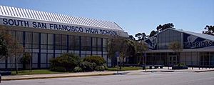
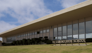
South San Francisco is part of the South San Francisco Unified School District. This district also serves parts of Daly City and San Bruno. The city has two public high schools: El Camino High School and South San Francisco High School. They have a friendly rivalry. There are also three public middle schools: Parkway Heights, Westborough, and Alta Loma. Many elementary schools are also in the city.
Several private schools are also here, like All Souls School and St. Veronica's School. The city has the South San Francisco Public Library, which is part of the Peninsula Library System.
Fire Department
The South San Francisco Fire Department has five fire stations. Each station has different fire trucks and equipment. For example, Station 61 has an Engine, a Rescue truck, and an ambulance. Station 65 is home to a Heavy Rescue vehicle for special situations. There is also a Rescue Boat at Oyster Point Marina.
Neighborhoods of South San Francisco
The city has a small downtown area. Many neighborhoods are west of Highway 101, like Mayfair Village and Winston Manor. East of Highway 101, you'll find industrial areas and modern office parks. The far western parts of the city are on a hillside, offering views of San Francisco Bay. This area is known as Westborough. The southern part of the city, near the airport, has many car repair shops and airport hotels.
Grand Avenue is the main street downtown. It has many small shops and restaurants. City Hall is also on Grand Avenue. Locals often just call it "Grand."
Here are some of the neighborhoods in South San Francisco:
- Avalon Park
- Brentwood
- Buri Buri
- Cypress/Airport
- East Side
- El Camino
- Francisco Terrace
- Lindenville
- Mayfair Village
- Mission Road
- Old Town
- Orange Park
- Oyster Point
- Paradise Valley
- Parkhaven
- Pecks Lot
- Serra Highlands
- Sign Hill
- Southwood
- Sterling Terrace
- Stonegate
- Susie Way
- Sunshine Gardens
- Terrabay
- Treasure Island
- West Winston Manor
- Westborough
- West Park
- Winston Manor
Students from Westborough and Buri Buri usually go to El Camino High School. Most students from Avalon, Brentwood, Sterling Terrace, and Parkway go to South San Francisco High School.
City Nicknames
South San Francisco is often called "South City." This is similar to how people call San Francisco "The City." Another common nickname is "SSF."
Fun Things to Do and See
Sign Hill Park
Sign Hill is a famous landmark in South San Francisco. You can see its huge letters from the San Francisco Peninsula or the nearby San Francisco International Airport. The sign says "SOUTH SAN FRANCISCO THE INDUSTRIAL CITY." The letters are made of painted concrete. The sign was put up in the 1920s. It is now a historic place. It shows how important industry was to the city's past.
Sign Hill is also a city park. It has 30 acres (12 hectares) of open space. There are almost 2 miles (3.2 km) of hiking trails. You can hike up to see the letters up close.
City Hall and Public Buildings
The South San Francisco City Hall is at 400 Grand Avenue. It looks like Independence Hall in Philadelphia. This building holds the Mayor's Office and other city services. The Police Department is in a new building on Chestnut Avenue.
Other Parks and Recreation
South San Francisco has many other parks. Orange Memorial Park has baseball fields, soccer fields, and a swimming pool. It also has picnic areas, a sculpture garden, and a skate park. A farmer's market is held there on Saturdays. Other parks like Alta Loma Park and Westborough Park offer sports and picnic spots.
The city also has Oyster Point, a park and marina on the San Francisco Bay. Here, you can watch planes from the airport, fish, or launch a kayak.
A special "linear park" runs through the city. It is built on top of the underground BART train line. This path is called Centennial Way. It is 3 miles (4.8 km) long and is great for biking and walking. It also has a dog park.
Other Interesting Places
The downtown area on Grand Avenue has buildings from the city's early days. The Plymire-Schwartz house, built in 1905, was the first hospital in the area. Now, it is run by the Historical Society. The 1916 Carnegie Library is next to the 1920 City Hall.
Bertolucci's is an Italian restaurant that has been open almost as long as the city. The South San Francisco Public Library has served the city since 1917. A new library is being built and will open in 2023.
The South San Francisco Historical Society has a museum. It has old photos, documents, and items from the city's past. The City Library also has a collection of historical materials.
The South San Francisco Farmers Market is at Orange Memorial Park. It sells fresh, California-grown products.
During the holidays, people in Parkway Estates decorate their homes with Christmas lights. This display is very popular. South San Francisco also has a bowling alley called Hometown Bowl. There are several gyms for basketball and other indoor sports. The city also has tennis courts and a bocce ball court. The private California Golf Club of San Francisco is also in the city.
Getting Around South San Francisco
South San Francisco is very close to the San Francisco International Airport (SFO). The BART station provides fast train service to SFO. It also connects to cities like San Francisco, Oakland, and Berkeley. The Caltrain service also runs between San Francisco and San Jose. Its station is near downtown on Grand Avenue.
A ferry service started in 2012. It runs from the South San Francisco Ferry Terminal at Oyster Point Marina. You can take the ferry to Oakland and Alameda on weekdays.
The city also has free shuttle services for everyone:
- A South City Shuttle connects the BART station to downtown. It goes to stores, the senior center, libraries, and parks.
- Shuttles link the Ferry Terminal to office areas during commute hours.
Two major highways run through the city: U.S. Route 101 (Bayshore Freeway) and Interstate 280. The historic El Camino Real also passes through the city.
South San Francisco also has LimeBike, a bike rental service.
Famous People From South San Francisco
- Victor Arnautoff: A painter known for a mural in the Linden Post Office.
- Ken Bastida: A television journalist.
- Rich Bordi: A former Major League Baseball (MLB) player.
- Willy Cahill: An Olympic Judo coach.
- Jim Campilongo: A rock guitarist.
- James H. Coleman: A city council member.
- Aristides Demetrios: The sculptor of the Wind Harp.
- Josh Emmett: A professional mixed martial artist (MMA).
- Jim Fregosi: A former MLB player and coach.
- Carl Gutierrez: A former Governor of Guam.
- Walt Harris: A college football coach.
- Milford Hodge: A former NFL player.
- Patrick Hunter: A former NFL player.
- Greg Jones: A former NFL running back for the Minnesota Vikings.
- William J. Justice: A Catholic bishop.
- Sebastian Lletget: A professional soccer player.
- Henry Miller: A famous rancher and businessman.
- Kevin Mullin: A politician.
- Rex Navarrete: A Filipino comedian.
- Leo Ryan: A politician who was assassinated.
- Roger Ruzek : A former NFL player.
- Aaron Solo A professional wrestler.
- Masayoshi Son: A Japanese-Korean entrepreneur.
- Mike Solari: An NFL coach.
- Gustavus Franklin Swift: The founder of Swift & Company, who helped plan the city.
- Darren Uyenoyama: A professional mixed martial artist (MMA).
- Easop Winston: An NFL player.
- Francis Wong: A jazz musician.
- Kurt Yaeger: An actor and disability advocate.
- Jim Zylker: An Olympic and professional soccer player.
Sister Cities
South San Francisco has five sister cities around the world:
 Atotonilco, Mexico
 Kishiwada, Japan
 Lucca, Italy
 Pasig, Philippines
 Saint-Jean-Pied-de-Port, France
See also
 In Spanish: South San Francisco para niños
 | Dorothy Vaughan |
 | Charles Henry Turner |
 | Hildrus Poindexter |
 | Henry Cecil McBay |


