Interstate 280 (California) facts for kids
Quick facts for kids
Interstate 280 |
||||
|---|---|---|---|---|
|
I-280 highlighted in red
|
||||
| Route information | ||||
| Defined by S&HC § 580 | ||||
| Maintained by Caltrans | ||||
| Length | 57.22 mi (92.09 km) | |||
| Existed | September 15, 1955 by FHWA July 1, 1964 by Caltrans–present |
|||
| Tourist routes |
||||
| Major junctions | ||||
| South end | ||||
| North end | King Street in San Francisco | |||
| Location | ||||
| Counties: | Santa Clara, San Mateo, San Francisco | |||
| Highway system | ||||
| Auxiliary route of the Interstate Highway System Main • Auxiliary • Business State highways in California(list • pre-1964)
|
||||
Interstate 280 (I-280) is a major highway in the San Francisco Bay Area of Northern California. It stretches about 57 miles (92 km) from San Jose to San Francisco. This highway is special because it runs mostly west of the main cities on the San Francisco Peninsula.
I-280 is known by a few different names. A big part of it, from San Jose to Daly City, is called the Junipero Serra Freeway. This name honors Junipero Serra, a Spanish friar who started many missions in California long ago. Some signs even call it the "World's Most Beautiful Freeway" because of its amazing views.
Closer to San Francisco, the highway changes names. From Daly City to US 101, it's called the John F. Foran Freeway. The very northern part, leading into San Francisco, is known as the Southern-Embarcadero Freeway.
Did you know that I-280 is one of only two Interstate highways with the same number on both the East and West Coasts of the United States? The other is I-110.
Also, I-280 used to be shown on the map app icon for Apple's phones and computers. This is because the highway goes right through Cupertino, where Apple's main offices are located!
What is I-280 Like?

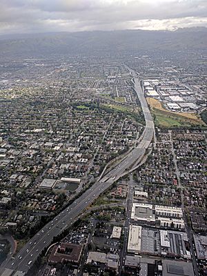
I-280 begins in San Jose at a big interchange called the Joe Colla Interchange. Here, it connects with I-680 and US 101. From there, it heads north, passing through cities like Santa Clara, Cupertino, and Los Altos.
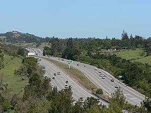
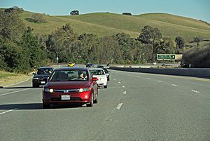
As it continues, I-280 follows a very scenic path. It runs along the western side of the San Francisco Peninsula, with beautiful views of the Santa Cruz Mountains. You might even catch glimpses of San Francisco Bay! This part of the highway is often called the "World's Most Beautiful Freeway." It's special because hills often block the view of the cities, making the drive feel very natural.
A cool fact about this scenic part is that the freeway actually runs along the edge of the San Andreas Fault rift valley. This is a famous geological fault line. There's also a pretty 6-mile (10 km) stretch near Hillsborough and Belmont where you can see the Crystal Springs Reservoir. This reservoir gets its water from far away, all the way from Hetch Hetchy Valley in Yosemite National Park!
For most of its journey, I-280 runs a few miles west of US 101. Both highways connect San Jose and San Francisco. However, US 101 goes through busy city areas, while I-280 offers a more peaceful, scenic drive. Most people living on the San Francisco Peninsula live somewhere between these two major highways.
I-280 is part of California's important California Freeway and Expressway System. It's also part of the National Highway System, which includes roads vital for the country's economy and travel. A large section of I-280 is even officially named a Scenic Highway. This means it passes through a "memorable landscape" with very few visual distractions.
Near the SR 92 intersection in Hillsborough, there's a 26-foot (8 m) tall statue of Father Serra. He's kneeling and pointing over the freeway, and drivers can see him from both directions. The part of I-280 from San Jose up to I-880 is also called the Sinclair Freeway, named after Joseph P. Sinclair, an important engineer.
History of I-280

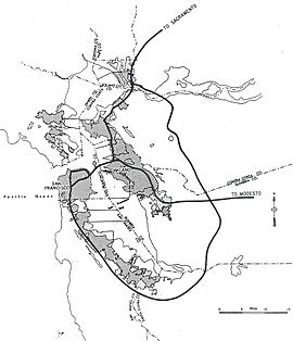
I-280 was first planned as an Interstate Highway on September 15, 1955. The original idea was for it to go from San Jose all the way north to the Golden Gate Bridge in San Francisco. However, these plans changed over time. The I-280 number was officially approved on November 10, 1958.
In 1964, California officially named the planned route for I-280. Later, in 1968, the route was changed again to mostly follow the path it does today.
The beautiful scenic part of I-280, between SR 85 in Cupertino and SR 84 in Woodside, was finished in the late 1960s. The section between SR 92 and SR 84 wasn't completed until the 1970s. Before that, cars had to use a different road called Cañada Road.
One interesting part of I-280's history is that it was supposed to connect directly to I-80 in San Francisco. However, this connection was never built. The northern end of I-280 used to stop suddenly in the air! After a big earthquake in 1989, the plans to connect I-280 to I-80 were completely dropped. The damaged Embarcadero Freeway was torn down, and I-280's northern end was redesigned in 1997 to its current ramps at King Street.
The start of I-280 in San Jose, the Joe Colla Interchange, also has a funny story. For years in the 1970s, the tall overpasses stood unfinished, earning jokes from locals. In 1976, someone even put an old car on the highest bridge overnight as a prank! This stunt might have helped convince the state to find money to finish the freeway, which finally opened in 1981.
In recent years, studies have looked at how often animals cross the road on I-280. Some parts of the highway, especially between San Bruno and Cupertino, are known for having more animal crossings. Drivers should always be aware of wildlife when driving on this scenic route.
Exits on I-280
| County | Location | mi | km | Exit | Destinations | Notes |
|---|---|---|---|---|---|---|
| Santa Clara | San Jose | 0.00 | 0.00 | — | Southern end of I-280; Joe Colla Interchange; I-680 continues east | |
| 0.36 | 0.58 | 1A | McLaughlin Avenue | Southbound exit and northbound entrance only | ||
| 1.29 | 2.08 | 1B | 11th Street, 10th Street | Signed as exit 1 northbound | ||
| 1.55 | 2.49 | 2A | Signed as exit 2 northbound | |||
| 2.20 | 3.54 | 2B | Almaden Boulevard, Vine Street | Southbound exit and northbound entrance only | ||
| 2.52 | 4.06 | 3A | ||||
| 2.88 | 4.63 | 3B | Bird Avenue | |||
| 3.88 | 6.24 | 4 | Race Street, Southwest Expressway | Northbound exit and southbound entrance only | ||
| 3.99 | 6.42 | Meridian Avenue | Southbound exit and northbound entrance only | |||
| 4.99 | 8.03 | 5A | Leigh Avenue, Bascom Avenue | |||
| 5.41 | 8.71 | 5B | Western end of the Sinclair Freeway | |||
| 5.41 | 8.71 | 5C | Stevens Creek Boulevard, West San Carlos Street | Northbound exit and southbound entrance only | ||
| 5.95 | 9.58 | 6 | Winchester Boulevard | Southbound exit and northbound entrance only | ||
| 7.33 | 11.80 | 7 | Saratoga Avenue – Saratoga | |||
| 8.51 | 13.70 | 9 | Lawrence Expressway (CR G2), Stevens Creek Boulevard | |||
| Cupertino | 9.76 | 15.71 | 10 | Wolfe Road | ||
| 10.82 | 17.41 | 11 | De Anza Boulevard | Former SR 85 | ||
| 12.12 | 19.51 | 12 | Signed as exits 12A (north) and 12B (south) | |||
| Los Altos | 12.83 | 20.65 | 13 | Foothill Expressway (CR G5), Grant Road | ||
| | 15.48 | 24.91 | 15 | Magdalena Avenue | ||
| Los Altos Hills | 16.43 | 26.44 | 16 | El Monte Road, Moody Road | ||
| | 19.76 | 31.80 | 20 | Page Mill Road (CR G3), Arastradero Road – Palo Alto | ||
| | 22.00 | 35.41 | 22 | Alpine Road – Portola Valley | ||
| San Mateo | | 23.62 | 38.01 | 24 | Sand Hill Road | |
| Woodside | 25.34 | 40.78 | 25 | |||
| 26.65 | 42.89 | 27 | Farm Hill Boulevard | |||
| 28.60 | 46.03 | — | Cañada Road | Entrances only | ||
| | 28.66 | 46.12 | 29 | Edgewood Road | ||
| | Ralph D. Percival Memorial Vista Point (northbound only) | |||||
| | Former rest area (northbound only; closed) | |||||
| | Gate Vista Point | |||||
| | 32.84 | 52.85 | 33 | |||
| | 34.33 | 55.25 | 34 | Southern end of SR 35 overlap | ||
| San Mateo Creek | 35.27 | 56.76 | Doran Memorial Bridge | |||
| | 35.43 | 57.02 | Crystal Springs Rest Area (northbound only) | |||
| Hillsborough | 36.24 | 58.32 | 36 | Black Mountain Road, Hayne Road | ||
| | 39.17 | 63.04 | 39 | Trousdale Drive | ||
| Millbrae | 39.67 | 63.84 | 40 | Millbrae Avenue | Northbound exit and southbound entrance only | |
| 40.53 | 65.23 | 41 | Larkspur Drive, Millbrae Avenue | Southbound exit and northbound entrance only | ||
| San Bruno | 41.29 | 66.45 | Northern end of SR 35 overlap; northbound exit and southbound entrance only | |||
| 42.28 | 68.04 | 42 | Crystal Springs Road | Southbound exit and northbound entrance only | ||
| 42.75 | 68.80 | 43A | San Bruno Avenue | Southbound access via exit 43B | ||
| 42.75– 43.02 |
68.80– 69.23 |
43 | Signed as exit 43A southbound, 43B northbound | |||
| 43.02 | 69.23 | 43B | Sneath Lane | Northbound access via exit 43A | ||
| South San Francisco | 44.05 | 70.89 | 44 | Avalon Drive | Northbound exit and southbound entrance only | |
| 44.63 | 71.83 | 45 | Westborough Boulevard | Northbound exit and southbound entrance via exit 44 | ||
| Daly City | 46.20 | 74.35 | 46 | Hickey Boulevard | ||
| 46.83 | 75.37 | 47A | Serramonte Boulevard | Southbound exit and northbound entrance only | ||
| 47.29 | 76.11 | 47 | Northbound signage | |||
| 47B | Southbound signage; southern end of SR 1 overlap | |||||
| 47.78 | 76.89 | 48 | Eastmoor Avenue, Sullivan Avenue | Southbound exit and northbound entrance only | ||
| 48.51 | 78.07 | 49A | John Daly Boulevard, Junipero Serra Boulevard | Signed as exit 49 southbound | ||
| 49.17 | 79.13 | 49B | Northern end of SR 1 overlap; northbound left exit and southbound entrance only | |||
| City and County of San Francisco | 50.18 | 80.76 | 50 | Southbound exit and northbound entrance only | ||
| 51.21 | 82.41 | 51 | Geneva Avenue, Ocean Avenue | |||
| 52.13 | 83.90 | 52 | Monterey Boulevard | Southbound exit and northbound entrance only | ||
| 52.14 | 83.91 | San Jose Avenue, Bosworth Street | Northbound exit and southbound entrance only | |||
| 52.72 | 84.84 | 53 | Alemany Boulevard, Mission Street | |||
| 53.78 | 86.55 | 54A | Southern end of Alemany Maze; signed as exit 54 southbound | |||
| 53.78 | 86.55 | 54B | Northbound exit and southbound entrance only; northern end of Alemany Maze | |||
| 55.06 | 88.61 | 55 | Cesar Chavez Street, 25th Street | |||
| 56.04 | 90.19 | 56 | Mariposa Street, 18th Street | |||
| 56.73 | 91.30 | 57 | Sixth Street | Northbound exit and southbound entrance only | ||
| 56.98 | 91.70 | — | Fifth Street | At-grade intersection; northern end of I-280 | ||
| — | King Street | Road continues beyond Fifth Street | ||||
| — | Fourth Street | Former northern end; replaced by King Street ramps; northbound exit only | ||||
| 1.000 mi = 1.609 km; 1.000 km = 0.621 mi | ||||||
See also
 In Spanish: Interestatal 280 (California) para niños
 | Delilah Pierce |
 | Gordon Parks |
 | Augusta Savage |
 | Charles Ethan Porter |


