
Santa Clara County, California facts for kids
Quick facts for kids
Santa Clara County
|
|||
|---|---|---|---|
 .jpg) .jpg) .jpg) .jpeg)  Clockwise: Downtown San Jose skyline; Hills near Morgan Hill; Alviso, San Jose; View of Santa Clara Valley; Almaden Reservoir; Stanford University.
|
|||
|
|||

Location in the state of California
|
|||
| Country | United States | ||
| State | California | ||
| Region | San Francisco Bay Area | ||
| Incorporated | February 18, 1850 | ||
| Named for | Mission Santa Clara de Asís, St. Clare of Assisi | ||
| County seat and largest city |
San Jose | ||
| Government | |||
| • Type | Council–CEO | ||
| • Body | Board of Supervisors | ||
| Area | |||
| • Total | 1,304 sq mi (3,380 km2) | ||
| • Land | 1,290 sq mi (3,300 km2) | ||
| • Water | 14 sq mi (40 km2) | ||
| Highest elevation | 4,216 ft (1,285 m) | ||
| Population
(2020)
|
|||
| • Total | 1,936,259 | ||
| • Density | 1,484.9/sq mi (573.31/km2) | ||
| GDP | |||
| • Total | $400.778 billion (2022) | ||
| Time zone | UTC−8 (Pacific) | ||
| • Summer (DST) | UTC−7 (Pacific Daylight Time) | ||
| Area codes | 408/669, 650 | ||
| FIPS code | 06-085 | ||
| GNIS feature ID | 277307 | ||
| Congressional districts | 16th, 17th, 18th, 19th | ||


Santa Clara County is a large county in California, United States. It is the sixth most populated county in the state. In 2020, about 1.9 million people lived there.
Santa Clara County is part of the larger San Jose–San Francisco–Oakland area. It is the most populated county in the San Francisco Bay Area and in Northern California.
The main city and county seat is San Jose. It is the 13th largest city in the U.S. and the third largest in California. San Jose is also the biggest city in Northern California.
Santa Clara County is known as the home of Silicon Valley. This area is a major hub for high technology companies. In 2015, it had one of the highest economic outputs per person in the world.
The county is located on the southern coast of San Francisco Bay. Most people live in the Santa Clara Valley. Recently, California has had many droughts. This has made it harder for the county to get enough water.
In 2020, the average household income was $130,890. This makes it one of the richest counties in the United States.
Contents
County Name: Where it Comes From

Santa Clara County gets its name from Mission Santa Clara de Asís. This mission was built in 1777. The mission itself was named after Saint Clare of Assisi.
County History
Santa Clara County was one of California's first counties. It was created in 1850 when California became a state. The first people to live here were the Ohlone tribe. They lived near Coyote Creek and Calaveras Creek.
In the early 1900s, this area was called the "Valley of the Heart's Delight." This was because of its beautiful natural scenery and many fruit orchards. The writer Jack London even called it the "sun-kissed Santa Clara Valley."
The first big technology company here was Hewlett-Packard. It started in a garage in Palo Alto in 1939. Later, IBM set up its West Coast office in San Jose in 1943. Other new tech companies like Varian Associates and Fairchild Semiconductor also came to the county.
The U.S. Navy had a big presence here. They gave many contracts to local electronics companies. The name "Silicon Valley" was first used in 1971. Over time, more and more tech companies moved in. This led to farming almost disappearing from the northern part of the county.
Today, Santa Clara County is home to about 6,500 high-tech companies. Many of the world's largest tech companies are here. These include AMD, Nvidia, Cisco Systems, Intel, Apple Inc., Hewlett-Packard, eBay, Google, and Yahoo!. Most of what people call Silicon Valley is located right here.
County Geography
Santa Clara County covers about 1,291 square miles (3,344 square kilometers).
It shares borders with several other counties. These include Alameda County, San Joaquin County, Stanislaus County, Merced County, San Benito County, Santa Cruz County, and San Mateo County.
The San Andreas Fault runs along the Santa Cruz Mountains. This is in the southern and western parts of the county.
Protected Natural Areas
- Don Edwards San Francisco Bay National Wildlife Refuge (part of it is in the county)
County Wildlife


Long ago, tule elk and pronghorn lived in Santa Clara County. Spanish explorers saw them in the 1700s. They described the elk as very large with huge horns. They also saw pronghorn, which looked like small deer and could run very fast.
In 1978, efforts began to bring tule elk back to the area. Thirty-two elk were moved from the Owens Valley to a ranch near Morgan Hill. Since then, the number of elk has grown. By 2012, about 400 tule elk lived in parts of Santa Clara and Alameda County.
Today, there are several herds of elk in the eastern part of the county. You can often see them from U.S. Highway 101. Experts hope to help the elk spread to other areas.
Pronghorn were also brought back in 1990. However, their numbers have gone down due to various reasons.
The Nature Conservancy is working to protect land in the Mount Hamilton area. They have saved over 100,000 acres of land. This helps protect habitats for animals like the California tiger salamander and tule elk.
Santa Clara County has many Superfund Sites. These are places that need to be cleaned up because of hazardous materials. Most of these sites were caused by high-tech companies in Silicon Valley.
County Population
| Historical population | |||
|---|---|---|---|
| Census | Pop. | %± | |
| 1860 | 11,912 | — | |
| 1870 | 26,246 | 120.3% | |
| 1880 | 35,039 | 33.5% | |
| 1890 | 48,005 | 37.0% | |
| 1900 | 60,216 | 25.4% | |
| 1910 | 83,539 | 38.7% | |
| 1920 | 100,676 | 20.5% | |
| 1930 | 145,118 | 44.1% | |
| 1940 | 174,949 | 20.6% | |
| 1950 | 290,547 | 66.1% | |
| 1960 | 642,315 | 121.1% | |
| 1970 | 1,064,714 | 65.8% | |
| 1980 | 1,295,071 | 21.6% | |
| 1990 | 1,497,577 | 15.6% | |
| 2000 | 1,682,585 | 12.4% | |
| 2010 | 1,781,642 | 5.9% | |
| 2020 | 1,936,259 | 8.7% | |
| 2023 (est.) | 1,877,592 | 5.4% | |
| U.S. Decennial Census 1790–1960 1900–1990 1990–2000 2010 2020 |
|||
Population in 2020
In 2020, Santa Clara County had a population of 1,936,259 people.
| Race / Ethnicity (NH = Non-Hispanic) | Pop 2010 | Pop 2020 | % 2010 | % 2020 |
|---|---|---|---|---|
| White alone (NH) | 626,909 | 555,708 | 35.19% | 28.70% |
| Black or African American alone (NH) | 42,331 | 42,148 | 2.38% | 2.18% |
| Native American or Alaska Native alone (NH) | 4,042 | 3,240 | 0.23% | 0.17% |
| Asian alone (NH) | 565,466 | 753,399 | 31.74% | 38.91% |
| Native Hawaiian or Pacific Islander alone (NH) | 6,252 | 5,945 | 0.35% | 0.31% |
| Other race alone (NH) | 3,877 | 10,195 | 0.22% | 0.53% |
| Mixed race or Multiracial (NH) | 53,555 | 78,267 | 3.01% | 4.04% |
| Hispanic or Latino (any race) | 479,210 | 487,357 | 26.90% | 25.17% |
| Total | 1,781,642 | 1,936,259 | 100.00% | 100.00% |
Population Trends

Since 2014, Asian Americans have become the largest ethnic group in Santa Clara County.
In 2013, Santa Clara County had the highest average household income in California. The average was $84,741.
County Economy
The county's economy is mostly based on services. Technology, like computer hardware and software, is a huge part of this. But the county also has many retail stores and office jobs.
The San Jose/Sunnyvale/Santa Clara area is one of the best-performing metro areas in the U.S. In 2011, its total economic output was $176.7 billion. This means it produced a lot of goods and services.
The economy here has grown a lot. This growth is linked to the high cost of homes. In August 2013, the average price for a single-family home was over $1 million. By late 2021, the average home value was $1,253,400. This makes it one of the most expensive places to live in the U.S.
Education in the County
Schools for Kids and Teens
Santa Clara County has many school districts. They are divided into three types:
- Unified School Districts
These districts include elementary, middle, and high schools.
- Gilroy Unified School District
- Milpitas Unified School District
- Morgan Hill Unified School District
- Palo Alto Unified School District
- Patterson Joint Unified School District
- San Jose Unified School District
- Santa Clara Unified School District
- High School Districts
These districts only have high schools.
- Campbell Union High School District
- East Side Union High School District
- Fremont Union High School District
- Los Gatos-Saratoga Joint Union High School District
- Mountain View–Los Altos Union High School District
- Elementary School Districts
These districts only have elementary and sometimes middle schools.
- Alum Rock Union Elementary School District
- Berryessa Union Elementary School District
- Cambrian Elementary School District
- Campbell Union Elementary School District
- Cupertino Union Elementary School District
- Evergreen Elementary School District
- Franklin-McKinley Elementary School District
- Lakeside Joint Elementary School District
- Loma Prieta Joint Union Elementary School District
- Los Altos Elementary School District
- Los Gatos Union Elementary School District
- Luther Burbank Elementary School District
- Moreland School District
- Mountain View Whisman Elementary School District
- Mount Pleasant Elementary School District
- Oak Grove Elementary School District
- Orchard Elementary School District
- Saratoga Union Elementary School District
- Sunnyvale Elementary School District
- Union School District
Libraries
The Santa Clara County Library system serves many cities and areas. These include Campbell, Cupertino, Gilroy, Los Altos, Los Altos Hills, Milpitas, Monte Sereno, Morgan Hill, Saratoga, and other unincorporated areas. Some cities have their own separate library systems.
Getting Around: Transportation
Airports
_(2).jpg)
The main airport in the county is Norman Y. Mineta San José International Airport (SJC). It has flights to other countries and many cities in the western U.S.
San Francisco International Airport (SFO) is also used by many people in Santa Clara County.
There are also smaller airports like Moffett Federal Airfield, Palo Alto (PAO), San Jose (Reid-Hillview) (RHV), and San Martin(E16).
Trains

.jpg)
Santa Clara County has several train services:
- Caltrain: This train takes people from Gilroy through San Jose and Silicon Valley all the way north to San Francisco.
- VTA light rail: This train system mainly serves San Jose. One line goes north to Mountain View.
- Altamont Corridor Express: This train connects Santa Clara and San Jose to places like Stockton.
- Amtrak: This train offers services to Sacramento and Oakland. The Coast Starlight train also stops in San Jose.
- BART: This train system currently serves Milpitas and North San Jose. There are plans to extend it to downtown San Jose and Santa Clara.
Roads

Buses
The Santa Clara Valley Transportation Authority (VTA) runs the bus system in Santa Clara County.
Bike Paths
The VTA is also building a network of bike paths across the county. These paths are part of the larger San Francisco Bay Area bike network.
- Bikeways Map (Effective April 2011)
Major Roads
The county has many freeways and expressways. Expressways are like highways but can have intersections where cars stop. In Santa Clara County, these expressways are managed by the county, not the state.
Here are some of the main highways:
 Interstate 280
 Interstate 680
 Interstate 880
 U.S. Route 101
 State Route 9
 State Route 17
 State Route 25
 State Route 35
 State Route 82
 State Route 85
 State Route 87
 State Route 130
 State Route 152
 State Route 156
 State Route 237
County Roads
- Santa Clara County expressway system
 County Route G2—Lawrence Expressway
 County Route G3—Page Mill Road/Oregon Expressway
 County Route G4—San Tomas Expressway/Montague Expressway
 County Route G5—Foothill Expressway
 County Route G6—Central Expressway
 County Route G7—Bloomfield Avenue
 County Route G8—Almaden Expressway
 County Route G9—Leavesley Road/Ferguson Road
 County Route G10—Blossom Hill Road
 County Route G21—Capitol Expressway
County Parks
Santa Clara County Parks and Recreation Department manages many parks. Many of these parks were created in the late 1970s.
- Almaden Quicksilver County Park
- Grant Ranch Park
- Henry W. Coe State Park
- Sanborn Park
- Vasona Park
There are also open space preserves:
- El Sereno Open Space Preserve
Ulistac Natural Area is another special place. Volunteers help remove plants that don't belong and plant native ones. This area is important for migratory birds and butterflies.
County Climate
|
||||||||||||||||||||||||||||||||||||||||||||||||||||||||||||||||||||||||||||||||||||||||||||||||
Sister Counties
Santa Clara County has a "Sister County" program. This program helps build friendships and understanding with other countries. It connects with places where many people in the county originally came from. As of 2023, Santa Clara County has two sister counties:
 Metropolitan City of Florence, Italy
 Hsinchu County, Taiwan (Republic of China)
Communities in Santa Clara County


.jpg)


Cities
There are 15 incorporated cities and towns in Santa Clara County:
Towns
Census-Designated Places (CDPs)
These are areas that are like towns but are not officially incorporated as cities.
- Alum Rock
- Burbank
- Cambrian Park
- East Foothills
- Fruitdale
- Lexington Hills
- Loyola also known as Loyola Corners
- San Martin
- Stanford
Unincorporated Communities
These are smaller communities that are not part of any city or CDP.
- Bell Station
- Casa Loma
- Chemeketa Park
- Coyote
- East San Jose
- Llagas-Uvas
- Madrone (now part of Morgan Hill)
- Redwood Estates
- Rucker
- San Antonio
- Sveadal
Population Ranking of Communities
This table shows the population of cities and towns in Santa Clara County based on the 2020 census.
† county seat
| Rank | City/Town/etc. | Municipal type | Population (2020 Census) |
|---|---|---|---|
| 1 | † San Jose | City | 1,013,240 |
| 2 | Sunnyvale | City | 155,805 |
| 3 | Santa Clara | City | 127,647 |
| 4 | Mountain View | City | 82,376 |
| 5 | Milpitas | City | 80,273 |
| 6 | Palo Alto | City | 68,572 |
| 7 | Cupertino | City | 60,381 |
| 8 | Gilroy | City | 59,520 |
| 9 | Morgan Hill | City | 44,686 |
| 10 | Campbell | City | 43,959 |
| 11 | Los Gatos | Town | 33,529 |
| 12 | Los Altos | City | 31,625 |
| 13 | Saratoga | City | 31,051 |
| 14 | Stanford | CDP | 21,150 |
| 15 | Alum Rock | CDP | 12,042 |
| 16 | Los Altos Hills | Town | 8,489 |
| 17 | San Martin | CDP | 7,008 |
| 18 | East Foothills | CDP | 6,803 |
| 19 | Burbank | CDP | 4,940 |
| 20 | Cambrian Park | CDP | 3,719 |
| 21 | Loyola | CDP | 3,491 |
| 22 | Monte Sereno | City | 3,479 |
| 23 | Lexington Hills | CDP | 2,492 |
| 24 | Fruitdale | CDP | 989 |
Images for kids
-
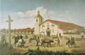
Mission Santa Clara de Asís in 1849.

See also
 In Spanish: Condado de Santa Clara para niños
