
Loyola, California facts for kids
Quick facts for kids
Loyola
|
|
|---|---|

Location in Santa Clara County and the state of California
|
|

Loyola
Location in the United States
|
|
| Country | United States |
| State | California |
| County | Santa Clara |
| Area | |
| • Total | 1.468 sq mi (3.803 km2) |
| • Land | 1.468 sq mi (3.803 km2) |
| • Water | 0 sq mi (0 km2) 0% |
| Elevation | 243 ft (75 m) |
| Population
(2020)
|
|
| • Total | 3,491 |
| • Density | 2,378.1/sq mi (917.96/km2) |
| Time zone | UTC-8 (Pacific) |
| • Summer (DST) | UTC-7 (PDT) |
| ZIP code |
94024
|
| Area code | 650 |
| FIPS code | 06-44378 |
| GNIS feature IDs | 1867038, 2408147 |
Loyola is a special kind of community in Santa Clara County, California, United States, called a census-designated place. This means it's an area that looks like a town but isn't officially governed as one. In 2020, about 3,491 people lived here.
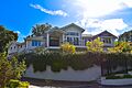
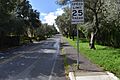
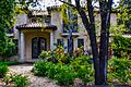
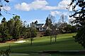
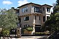
Loyola is known for being one of the wealthiest neighborhoods in America. You can find all kinds of homes here, from small cottages to huge ranch houses and even mansions. It's a very green, woodsy area. The famous Los Altos Golf & Country Club is located here. Loyola sits between the city of Los Altos and the town of Los Altos Hills. It was also home to the very first headquarters of Facebook, often called the "Facebook House." The neighborhood gets its name from Ignatius of Loyola, a Spanish saint who founded the Jesuits.
Contents
History of Loyola: How the Area Got Its Name
The name Loyola comes from a plan made in 1904 by the Jesuits of Santa Clara University. They wanted to build a new university in this area. They planned to name it after their founder, Saint Ignatius of Loyola.
The new university would have been built where the golf course is today, on Country Club Drive. However, the plan faced many delays and money problems. These issues became even worse after the big 1906 San Francisco earthquake. Because of these challenges, the university project was never finished.

Geography of Loyola: Where It Is Located
Loyola is located in California at these coordinates: 37°21′5″N 122°6′2″W / 37.35139°N 122.10056°W.
The United States Census Bureau says that Loyola covers a total area of about 1.5 square miles (3.8 square kilometers). All of this area is land, with no large bodies of water.
People and Community in Loyola
Loyola is home to a diverse group of people. Let's look at some facts about the population.
Loyola's Population in 2010
In 2010, the 2010 United States Census counted 3,261 people living in Loyola. This means there were about 2,221 people per square mile. Most people in Loyola lived in family homes.
- About 25% of the population was under 18 years old.
- About 20% of the population was 65 years or older.
- The average age of people in Loyola was 47.5 years.
Most homes in Loyola were owned by the people living in them. About 90% of the homes were owner-occupied, while about 9% were rented.
Loyola's Population in 2000
The census in 2000 showed that 3,478 people lived in Loyola. There were 1,275 households, which are groups of people living together in one home.
- About 23% of the people were under 18 years old.
- About 16% of the people were 65 years or older.
- The average age was 45 years.
Education in Loyola
Students in Loyola attend schools in two different districts.
- Younger students, from kindergarten to 8th grade, go to schools in the Los Altos School District.
- Older students, from 9th to 12th grade, attend high schools in the Mountain View-Los Altos Union High School District.
Images for kids
-
Loyola, Los Altos, CA
-
Olive Trees
-
280, Loyola, Los Altos, CA
-
Loyola, CA
-
A fairway in Los Altos, CA
-
A street in Loyola, Los Altos, CA


See also
 In Spanish: Loyola (California) para niños
