
1906 San Francisco earthquake facts for kids

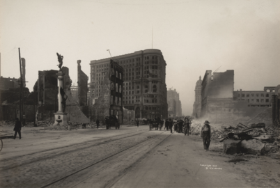
Ruins in the vicinity of Post and Grant Avenue
|
|
| UTC time | 1906-04-18 13:12:27 |
|---|---|
| ISC event | 16957905 |
| USGS-ANSS | ComCat |
| Local date | April 18, 1906 |
| Local time | 05:12:27 (PST) |
| Magnitude | 7.9 Mw |
| Depth | 5 mi (8.0 km) |
| Epicenter | 37°45′N 122°33′W / 37.75°N 122.55°W |
| Fault | San Andreas Fault |
| Type | Strike-slip |
| Areas affected | North Coast San Francisco Bay Area Central Coast United States |
| Max. intensity | XI (Extreme) |
| Tsunami | Yes |
| Casualties | 700–3,000+ |
The 1906 San Francisco earthquake was a very powerful earthquake. It hit the coast of Northern California early on Wednesday, April 18, 1906. The earthquake happened at 5:12 AM Pacific Standard Time.
Scientists estimate its strength was 7.9 on the Moment magnitude scale. The shaking was extremely strong, reaching level XI (Extreme) on the Mercalli intensity scale. This intense shaking was felt from Eureka in the north to the Salinas Valley in the south.
Soon after the earthquake, huge fires started in San Francisco. These fires burned for several days. More than 3,000 people lost their lives. Over 80% of the city was destroyed. This event is known as the deadliest earthquake in United States history. It caused the greatest loss of life from a natural disaster in California's history.
Contents
- Understanding Earthquakes: Tectonic Plates
- The Great Shaking: What Happened During the Earthquake
- The Impact: Damage and Loss
- Fires: The Greater Destruction
- Aftermath: Rebuilding and Lessons Learned
- Remembering the Disaster: Centennial Events
- Willard Worden's Photographs
- Panoramas: Views of the Destruction
- See also
Understanding Earthquakes: Tectonic Plates
The San Andreas Fault is a long crack in the Earth's crust. It marks where two giant pieces of the Earth's surface, called tectonic plates, meet. These are the Pacific plate and the North American plate.
The fault is a strike-slip fault. This means the plates mostly slide past each other sideways. The Pacific plate moves northward compared to the North American plate. This fault stretches for about 810 miles (1,300 km) across California. It goes from the Salton Sea in the south to Cape Mendocino in the north. During the 1906 earthquake, the ground moved sideways by as much as 28 feet (8.5 meters) in some places.
The Great Shaking: What Happened During the Earthquake

_with_damage_from_the_1906_San_Francisco_earthquake_near_north_portal.png)
The 1906 earthquake happened before the Richter scale was invented. Today, experts agree its strength was about 7.9 on the modern moment magnitude scale. Some estimates have been as high as 8.3.
The earthquake caused big changes in the Earth's crust. The stress built up along the San Andreas Fault was released. This caused damage along a 280-mile (450 km) section of the fault. The rupture, or break, in the fault spread both north and south for a total of 296 miles (476 km). People felt the shaking from Oregon all the way to Los Angeles. It was even felt as far inland as central Nevada.
A strong smaller earthquake, called a foreshock, happened about 20 to 25 seconds before the main shock. The main shaking lasted for about 42 seconds. For many years before 1906, there were more small earthquakes in northern California than usual. Scientists now believe these were caused by heavy loads of sediment in coastal bays. This sediment came from hydraulic mining during the California gold rush.
For a long time, people thought the earthquake's starting point, called the epicenter, was near Olema. This is in Marin County. Later, a scientist suggested it was likely offshore, northwest of the Golden Gate. Today, most studies agree the epicenter was offshore. This is supported by a small tsunami (ocean wave) that was recorded. The wave was about 3 inches (8 cm) high.
How Strong Was the Shaking?
The shaking was measured using the Modified Mercalli intensity scale. In San Francisco and places like Santa Rosa, the intensity reached XI (Extreme). This means there was devastating destruction.
Scientists noticed that the shaking was much stronger in areas built on soft ground. These were places like sediment-filled valleys or former bay areas where the soil became like liquid (called soil liquefaction). Areas built on solid rock shook less. Today, building codes consider these different ground conditions to make structures safer.
Aftershocks: More Shakes
After the main earthquake, there were many smaller earthquakes called aftershocks. There were fewer aftershocks than expected for such a large quake. Most of them happened near the ends of the main fault break. Some occurred on other faults, like the Hayward Fault. The largest aftershock was about 6.7 magnitude. It happened west of Eureka a few days later.
The Impact: Damage and Loss


At first, reports said between 375 and 500 people died. However, many deaths in Chinatown were not officially counted. The total number of deaths is still uncertain. Estimates range from 700 to over 3,000. In 2005, the city officially recognized the number of 3,000+ deaths. Most deaths were in San Francisco. But 189 people died in other parts of the Bay Area. Cities like Santa Rosa and San Jose also suffered great damage.
Between 227,000 and 300,000 people lost their homes. This was out of a city population of about 410,000. Many people moved across the bay to Oakland and Berkeley. Parks and beaches became temporary camps filled with tents. Many of these camps were still in use more than two years later.
XI (Extreme)X (Extreme)IX (Violent)VIII (Severe)VII (Very strong)VI (Strong)V (Moderate)IV (Light)III (Weak)
| Selected Mercalli intensities | ||
| MMI | Locations | |
|---|---|---|
| San Francisco, Santa Rosa | ||
| Sebastopol, San Bruno | ||
| San Jose, Point Arena | ||
| Eureka, Salinas | ||
| Truckee, Parkfield | ||
| Willows, Fresno | ||
| Chico, Paso Robles | ||
| Dunsmuir, Bakersfield | ||
| Santa Monica, Indio | ||
| U.S. Earthquake Intensity Database, NGDC | ||
Before the disaster, San Francisco was the ninth-largest city in the U.S. It was the biggest city on the West Coast. It was a major center for finance, trade, and culture. The city's port was the busiest on the West Coast. Over 80% of the city was destroyed by the earthquake and fires.
San Francisco rebuilt quickly. However, the disaster caused trade and people to move south to Los Angeles. Los Angeles later became the largest city in the West. Many artists and writers moved to Carmel-by-the-Sea. They helped create an arts community there.
The 1908 Lawson Report studied the earthquake. It showed that the San Andreas Fault also ran near Los Angeles. This earthquake was the first major natural disaster to be widely recorded with photos and films. This happened when the science of seismology (the study of earthquakes) was growing.
Damage in Other Cities
While San Francisco suffered greatly, other cities also had much damage. San Jose and Santa Rosa were hit hard. The entire downtown area of Santa Rosa was almost completely destroyed.
Fires: The Greater Destruction

The fires that followed the earthquake caused even more damage. Experts believe that at least 80% of the total destruction came from these fires. Within three days, over 30 fires destroyed about 25,000 buildings. These fires covered 490 city blocks. They were often started by broken gas pipes. The fires caused an estimated $350 million in damage at the time. This would be billions of dollars today.
One famous fire was the "Ham and Eggs" fire. It started when a woman lit her stove for breakfast. She did not know her chimney was badly damaged. This fire destroyed a 30-block area. It burned down a college, the Hall of Records, and City Hall.
Some fires started when firefighters tried to create firebreaks. They used dynamite to demolish buildings. But they were not trained in using explosives. The dynamited buildings often caught fire instead. The city's fire chief, Dennis T. Sullivan, had died from injuries from the earthquake. This made it harder to organize firefighting efforts. In total, the fires burned for four days and nights.


Most of the destruction was blamed on the fires. This was because many insurance policies covered fire damage, but not earthquake damage. Some people, hoping to get money from their insurance, might have started fires in buildings already damaged by the earthquake. An Army officer reported that a fireman told him people were setting their houses on fire for this reason.
The famous Palace Hotel was lost in the fire. It was later rebuilt. Many famous people had stayed there, including royalty and performers. The opera singer Enrico Caruso was staying at the Palace Hotel. He was woken by the earthquake. He managed to leave the city and vowed never to return. His opera company lost all its costumes and sets.
Many scientific laboratories were destroyed by the fires. Alice Eastwood, a botanist, saved the entire plant collection of the California Academy of Sciences. This was the largest plant collection in the western United States. The original California flag from the 1846 Bear Flag Revolt was also lost. It was stored in a state building in San Francisco.
Aftermath: Rebuilding and Lessons Learned

The disaster caused property losses of over $400 million in 1906 money. This is like billions of dollars today. Insurance companies paid out between $235 million and $265 million. They often only paid for fire damage, as earthquake damage was usually not covered.
Leaders and business owners tried to downplay the earthquake's effects. They feared losing money from outside investors needed for rebuilding. California Governor George Pardee quickly said the city would be rebuilt fast. He did not even mention the earthquake in his statement. The numbers for deaths and damage were often changed to seem less severe.
Plans to rebuild the city started right away. Many banks were burned, so their fire-proof vaults had to cool for days before they could be opened. The Bank of Italy (now Bank of America) had moved its money. It was able to provide funds immediately. Its president also sent ships to bring lumber for rebuilding.
In 1913, John C. Branner, a geologist, complained that the government was not studying earthquakes enough. He said people were afraid that talking about earthquakes would scare away business. He argued that preparing for earthquakes was possible and necessary.
Eleven days after the quake, a special baseball game was played in New York City. It raised money for the survivors. William James, a famous American psychologist, was at Stanford during the earthquake. He visited San Francisco to see the damage. He was impressed by how positive the survivors were. He also noted how quickly they organized services and brought order to the chaos.
H. G. Wells, a famous writer, was in New York when he heard about the earthquake. He noticed that people were not sad or worried about the city being destroyed forever. Everyone believed San Francisco would be rebuilt, bigger and better.


Rebuilding San Francisco
The earthquake was very important for the University of California, San Francisco (UCSF). Before 1906, the school did not have its own hospital. After the earthquake, over 40,000 people moved to a temporary tent city in Golden Gate Park. UCSF faculty treated these people. This experience led the school to build its own health facilities. In 1907, a building was renovated for patient care. This also led to the creation of the UC Training School for Nurses.
To rebuild, San Francisco needed money from other parts of the country. So, leaders made sure to emphasize that the city would be strong again. They created new, strict building codes. They also kept the official death toll low.
A famous city planner, Daniel Burnham, created a grand plan for San Francisco. He suggested wide avenues, large boulevards, and a huge civic center. He also proposed a massive urban park. However, this plan was not fully used. Landowners and investors did not want the city to buy so much land.
Even so, some of Burnham's ideas were later used. These included a neoclassical civic center, wider streets, and a subway under Market Street. The Coit Tower on Telegraph Hill also came from his ideas.
City leaders also tried to move the Chinese population out of the city center. But the Chinese residents rebuilt Chinatown in a new, modern Western style. The destruction of City Hall and other records helped thousands of Chinese immigrants claim residency and citizenship. This allowed their relatives to come from China, despite the Chinese Exclusion Act, a law that made it hard for Chinese people to enter the U.S.
The earthquake also led to the growth of the Pacific Heights neighborhood. Most mansions on Nob Hill were destroyed. The wealthy looked for new land to the west. This land was cheaper, less developed, and had better views.
Rebuilding was fast. By 1915, the city was largely restored. This was in time for the Panama–Pacific International Exposition. This event celebrated the city's recovery. Since 1915, the city has remembered the disaster each year. Survivors gather at Lotta's Fountain. This fountain was a meeting point during the disaster.
Temporary Homes: Relief Houses


The Army built 5,610 "relief houses" from redwood and fir wood. These houses provided homes for 20,000 people who lost theirs. The houses were designed by John McLaren. They were grouped into 11 camps. People rented them for two dollars a month. They were painted navy blue because the military had a lot of that paint.
At its busiest, the camps housed 16,448 people. By 1907, most people had moved out. The small houses were then used as garages, storage, or shops. Each cottage cost about $100 to build. The $2 monthly rent went towards buying the house for $50. The last official refugee camp closed on June 30, 1908.
Most of these cottages are gone today. But at least 30 still exist. Two historically restored ones are in the Presidio. Others have been added to private homes, especially in the Bernal Heights neighborhood. In 2006, one of these small 720 square foot (67 m²) homes sold for over $600,000.
A 2017 study found that the fire changed how land was used. Burned areas became more focused on businesses, not just homes. This created new business areas that still exist today.
Help from Around the World

News of the disaster quickly spread worldwide. Within days, over $5 million (in 1906 dollars) was raised for relief. London alone raised hundreds of thousands of dollars. Companies like Standard Oil and people like Andrew Carnegie each gave $100,000. The Parliament of Canada gave $100,000. Even the Bank of Canada gave $25,000. The United States Congress quickly approved $2.5 million for supplies. These included food and thousands of tents for the homeless.
These efforts were not always enough to help families fully recover. Wealthier city members were sometimes slow to help rebuild homes they were not responsible for. Everyone could get daily meals from communal soup kitchens. People from as far away as Idaho and Utah sent bread. Railroads helped coordinate these relief supplies.
Insurance and Financial Impact
Insurance companies faced huge claims of $250 million. They paid out between $235 million and $265 million. Often, they only paid for fire damage, as earthquake damage was usually not covered. At least 137 insurance companies were involved. Twenty companies went bankrupt. Lloyd's of London paid all its claims, over $50 million.
Insurance payments had a big effect on the world's financial system. Gold transfers from European insurance companies to San Francisco caused interest rates to rise. This led to fewer available loans. It eventually contributed to the Knickerbocker Trust Company crisis in October 1907, which caused a financial panic.
After the 1906 earthquake, there was a global discussion about excluding earthquake damage from fire insurance. Re-insurers pushed for this. By 1910, some countries, especially in Europe, started to exclude earthquake damage from fire insurance. In the U.S., the public strongly opposed this idea. In 1909, California passed a law that said fire insurance policies could not exclude earthquake damage. This meant insurers would have to pay again if another earthquake caused fires. Other countries facing earthquake risks followed California's example.
Remembering the Disaster: Centennial Events
The 1906 Centennial Alliance organized many events to remember the earthquake. These included award ceremonies, religious services, a National Geographic TV movie, and lectures. The USGS also published online documents. The tourism industry promoted the 100th anniversary in 2006.
Eleven survivors of the 1906 earthquake attended the 2006 commemorations. Irma Mae Weule (1899–2008) was the oldest survivor at 109 when she passed away. Vivian Illing (1900–2009) was thought to be the second oldest. Herbert Hamrol (1903–2009) was believed to be the last known survivor for a time.
Later, two more survivors were found: William Del Monte and Jeanette Scola Trapani. They had stopped attending events because it became too difficult. William Del Monte (1906–2016) was thought to be the last survivor. He passed away just before his 110th birthday.
In 2005, the film San Francisco Earthquake and Fire, April 18, 1906 was added to the National Film Registry. This newsreel documentary was made soon after the earthquake.
Willard Worden's Photographs
Willard Worden was a photographer in San Francisco. He took many pictures of the fire and its aftermath. He used a handheld camera and a view camera with glass negatives. He also photographed damage at Stanford University. His photos showed the destruction and were interesting to scientists and city planners. They were included in a major report about the earthquake. His prints are now in museums like the Museum of Modern Art.
After the disaster, only six marble columns and a lintel remained of the Alban N. Towne mansion on Nob Hill. From a certain angle, this empty porch perfectly framed the ruins of City Hall. This image became a symbol of the 1906 earthquake. Worden's photographs helped make it famous. In 1909, these columns were moved to Golden Gate Park. They are now known as Portals of the Past. They stand as a monument to the city's loss and its strength.
-
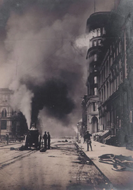
Firefighters battling a blaze.
-
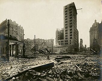
View from Kearny Street after the fire.
-
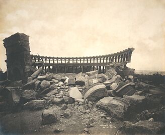
An observatory in ruins.
-
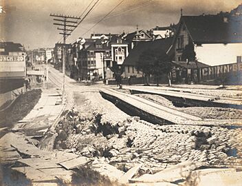
Damage on Union Street.
-
Market Street after the earthquake.
-
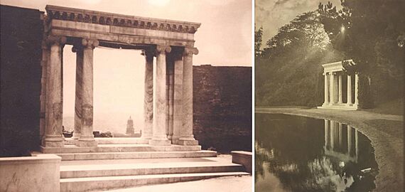
Portals of the Past: original location and after being moved to Golden Gate Park.


Panoramas: Views of the Destruction


See also
 In Spanish: Terremoto de San Francisco de 1906 para niños
- Committee of Fifty (1906)
- Earthquake engineering
- List of disasters in the United States by death toll
- List of earthquakes in 1906
- List of earthquakes in California
- List of earthquakes in the United States
- List of fires
