
Salinas River (California) facts for kids
The Salinas River (Rumsen: ua kot taiauačorx) is the longest river on the Central Coast of California. It stretches about 175 miles (282 km) and its water basin covers 4,160 square miles (10,774 km²). The river flows mostly north through the Salinas Valley, which is a long, narrow valley between mountain ranges south of Monterey Bay.
It starts in the Los Machos Hills of the Los Padres National Forest in southern San Luis Obispo County. From there, it flows north into Monterey County and finally reaches Monterey Bay, which is part of the Pacific Ocean. This happens about 5 miles (8 km) south of Moss Landing. The Salinas River is important for wildlife and provides water for farms and vineyards in the valley.
For many years, the Salinas River flowed all year round, from at least 1941 to 1989. However, because of more water being used for farming in the Salinas Valley, the river's lower parts (north of King City) were completely dry from 2013 to 2016. Heavy rains in the winter of 2016–2017 brought the water back to these lower parts in January 2017.
Quick facts for kids Salinas River |
|
|---|---|

View of the Salinas River near San Ardo in May 2008. During the rainier winter months, the river may occasionally reconnect with Monterey Bay. The San Ardo Oil Field is visible in the distance.
|
|

Map of the Salinas River watershed
|
|
| Native name | ua kot taiauačorx |
| Other name(s) | Rio del Monterey, Rio San Antonio, Rio San Elizario, Rio Santa Delfina |
| Country | United States |
| State | California |
| Cities | Paso Robles, Soledad, Salinas |
| Physical characteristics | |
| Main source | Los Machos Hills in the Los Padres National Forest San Luis Obispo County, California 2,150 ft (660 m) 35°12′57.2394″N 120°13′26.112″W / 35.215899833°N 120.22392000°W |
| River mouth | Monterey Bay 6 miles north of Marina, California 0 ft (0 m) 36°44′58″N 121°48′13″W / 36.74944°N 121.80361°W |
| Length | 175 mi (282 km) |
| Basin features | |
| Basin size | 4,160 sq mi (10,800 km2) |
| Tributaries |
|
Contents
How the River Flows
When the Portola expedition first explored the river in 1769, they described it as a "river watering a luxuriant plain" full of large fish. By the end of 2016, much of the river had become a dry streambed.
However, when there are very heavy rains, this dry streambed can quickly turn back into a fast-flowing river. During floods, it can even become over a mile wide. In the 1900s, big floods happened about every 3 to 10 years. The last major flood was in 1998.
The reason the river is often dry now might be more due to human activities than changes in weather. The amount of rain in the Salinas area hasn't changed much from historical averages. The average yearly rainfall in Salinas is about 13.26 inches (337 mm), and since 2000, it's been about 11.01 inches (280 mm).
More water is being used, mainly for farming, and dams on the river and its smaller streams might be causing the riverbed to be mostly dry. The Monterey County Water Resources Agency asks farmers to report how much groundwater they pump from the shrinking water supply under the Salinas Valley.
The river's natural environment, which once had Steelhead trout and many other animals, has been greatly affected. This is because of the high demand for water for farming, which makes the river dry for most of the year.
River's Long History
The Salinas River has a very interesting geological past, which scientists believe is unique among rivers on the west coast of North America. This idea comes from the discovery of the huge submarine canyon at the river's mouth, called the Monterey Canyon.
The Monterey Canyon is much longer and deeper than any other canyon along the Pacific coast of North America. But the Salinas River, as we know it today, doesn't seem powerful enough to have created such a massive canyon. Because of this, scientists think that millions of years ago, during the Miocene time period, the river was probably located near what is now Los Angeles. At that time, it might have been the ancient mouth of the Colorado River.
It's also believed that the Salinas River once drained a huge prehistoric lake called Lake Corcoran. This lake covered much of what is now California's Central Valley about 700,000 years ago. This was before the valley had an outlet to what is now San Francisco Bay.
Early People Along the River
About 13,000 years ago, during the end of the Pleistocene Ice Age, people first appeared along the California coast. Before Europeans arrived, the Native American groups living along the Salinas River were the Rumsen in the northern Salinas Valley and the Salinan in the southern valley. The Chalon and Esselen people also lived in areas near the river.
Europeans first saw the Salinas River on September 27, 1769. This was during the Spanish "colonizing expedition" led by Gaspar de Portolà. Spanish expeditions usually included soldiers and priests. The Franciscan priests with Portolà later built two missions along the river, which they called "el Rio de Monterey."
Spanish Missions
The new missions built along the Salinas River were the Mission Nuestra Señora de la Soledad, started in 1791, and the Mission San Miguel Arcángel, started in 1797. The Mission San Antonio de Padua was also built in the Salinas Valley around this time, but not directly on the river. These three missions were part of the chain of 21 missions built by the Spanish government in what is now California.
All three missions still exist today. The Soledad mission grew into the city of Soledad, and the San Miguel mission became the village of San Miguel. The San Antonio mission is now surrounded by Fort Hunter Liggett land.
River Changes Over Time
After the 1906 San Francisco earthquake, the river's mouth at Monterey Bay moved about 6 miles (10 km) south. It shifted from an area between Moss Landing and Watsonville to a new channel just north of Marina.
The growth of farming and settlements in the area has greatly increased the demand for water. This has had a big impact on the Salinas River. The river is now usually dry for most of the year. Downstream (north) of King City, it was completely dry from 2013 to 2016. However, the river has still had notable floods, such as in 1964 and 1995.
How the River Got Its Name
During the time when Spain and Mexico controlled California, the river was called "El Rio de Monterey." After the United States took over the area, it was renamed the Salinas River.
When the Spanish Portola Expedition first saw the river on September 27, 1769, they thought it might be the Carmel River, which had been discovered earlier. However, one of the members, Father Crespi, suggested it was a different river and should get a new name. But it seems the others in his group disagreed at the time.
The first agreed-upon name for the river, which appeared on many Spanish and Mexican maps, was Rio de Monterey. This name was probably given after the nearby town of Monterey, which was founded around the same time. The first time this name was written down was by Father Pedro Font on March 4, 1776. This name was used until at least 1850.
The river was apparently renamed the "Salinas" river by an American mapmaker in 1858. This was ten years after the United States gained California from Mexico in 1848. In 1858, the new name "Rio Salinas" first appeared on an American map. It was likely named after the nearby American town of Salinas, which was founded in 1854. The town itself was named after an old land grant called Rancho Las Salinas.
River's Path and Features
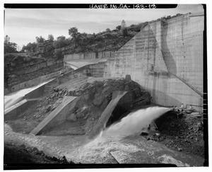
The Salinas River starts in southern San Luis Obispo County. This is about 2.5 miles (4 km) east of Pine Ridge, near Agua Escondido Road, coming down from the Los Machos Hills of the Los Padres National Forest. The only dam directly on the Salinas River is the Salinas Dam, which creates the small Santa Margarita Reservoir.
The Salinas River flows down a valley. On its southwest side is the Santa Lucia Mountain Range, and on its northeast side is the Gabilan Mountain Range. It flows past towns like Atascadero and Paso Robles. It also receives water from the Estrella River and controlled releases from the Nacimiento and San Antonio reservoirs through their tributary rivers in southern Monterey County.
The river then passes through the San Ardo Oil Field and into the main Salinas Valley. It flows past many small towns in the valley, including King City, Greenfield, and Soledad. In Soledad, it joins the Arroyo Seco, a stream known for flash floods.
The river flows about 3 miles (5 km) south of the city of Salinas. Then it cuts through Fort Ord and flows into central Monterey Bay, about 3 miles (5 km) west of Castroville. The last part of the river forms a lagoon, which is protected by the 367-acre Salinas River National Wildlife Refuge. Its connection to Monterey Bay is usually blocked by sand dunes, except when there are high water flows in winter.
Historical River Path
In the past, landowners changed the river's course by filling in the riverbed during the dry season. This allowed them to farm more land and use the water as they wished. The old riverbed went from the Old Salinas River and joined Elkhorn Slough on Monterey Bay near Moss Landing. The river now flows directly into the Pacific Ocean. The Old Salinas River channel, which goes north behind the sand dunes along the ocean, is now used as an overflow channel during the rainy season.
River's Wildlife
Before Hispanic and American settlers arrived, the Salinas River was home to many fish and beaver.
Fish Populations
The Arroyo Seco is the only major stream that flows into the Salinas River that has not been dammed. As of 2015, it still had a small group of Steelhead trout (Oncorhynchus mykiss). These trout used to spawn throughout the Salinas River watershed. The Estrella River also remains undammed. A 2015 study suggested that the survival of the river's steelhead trout might be difficult because the river often runs dry for most of the year.
Other streams that once supported steelhead trout included Paso Robles Creek, Jack Creek, Atascadero Creek, Santa Margarita Creek, and Trout Creek. It used to take over ten days for steelhead from the upper part of the river system to travel to the Pacific Ocean near the city of Marina. From there, the steelhead would migrate to the area west of the Aleutian Islands before returning to lay their eggs in the Salinas River's smaller streams. Since the river was dry from 2013 to 2016, the trout's life cycle, which needs them to migrate to the sea and back each year, was broken. The future of the river's steelhead trout is still uncertain.
In March 1776, Father Pedro Font described salmon in the Salinas River (then called Rio de Monterey) during the de Anza Expedition: "…there are obtained also many good salmon which enter the river to spawn. Since they are fond of fresh water they ascend the streams so far that I am assured that even at the mission of San Antonio some of the fish which ascend the Rio de Monterey have been caught. Of this fish we ate almost every day while we were here."
If Father Font was talking about salmon, not steelhead, his notes suggest that salmon once swam up the main Salinas River and its San Antonio River tributary to Mission San Antonio, near what is now Jolon. This supports other historical accounts that said Chinook salmon were found in the main river as far south as Atascadero. They were also found in southern streams like the Las Tablas Creek (a tributary of the Nacimiento River) and Jack Creek (a tributary of Paso Robles Creek west of Templeton).
Beaver Populations
After being hunted for their fur in the 1800s, California golden beaver (Castor canadensis subauratus) populations grew back. They spread from the mouth of the Salinas River to its San Antonio River tributary below the reservoir. Although some recent reports said beaver were no longer found in the northern parts of the river, a recent study found beaver throughout the entire Salinas River and almost all of its major tributaries.
Farming and the River
The Salinas River is used for irrigation in the Salinas Valley, making it one of the most productive agricultural areas in California. It is especially known for growing lettuce and artichokes in the United States.
The river is shallow above ground and often dry, with much of its water flowing underground. This underground flow comes from many underground water sources called aquifers. These aquifers are refilled by water from the Salinas River, especially from the Nacimiento and San Antonio lakes during the dry months.
In the 1700s and early 1800s, the river valley was part of El Camino Real. This was the main land route from southern to northern Alta California, used by Spanish explorers, missionaries, and early Mexican settlers.
River Road
Starting from Hill Town, California and going south along the western banks of the Salinas River to Gonzales, California is River Road. This road also runs along the edge of the Santa Lucia Highlands AVA, which is why it's known as the River Road Wine Trail.
Images for kids
-
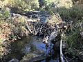
North American beaver have colonized the upper Salinas River watershed, as shown by this beaver dam 16 miles (26 km) upstream of Atascadero below the Salinas River dam. Courtesy of Stuart Suplick 2019

