
Santa Lucia Range facts for kids
Quick facts for kids Santa Lucia Range |
|
|---|---|

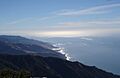
November 2005 view from summit of Cone Peak, the highest coastal mountain in the lower 48 US states.
|
|
| Highest point | |
| Peak | Junipero Serra Peak |
| Elevation | 5,857 ft (1,785 m) |
| Geography | |

Location in California
|
|
| Country | United States |
| State | California |
| Region | Monterey County San Luis Obispo County |
| Range coordinates | 36°3′3.861″N 121°28′8.769″W / 36.05107250°N 121.46910250°W |
| Topo map | USGS Cone Peak |


.jpg)
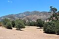
The Santa Lucia Mountains are a tough and beautiful mountain range found along the coast of central California. They stretch for about 140 miles (225 km) from Carmel in the north down to the Cuyama River in San Luis Obispo County. These mountains are always very close to the Pacific Ocean, usually less than 11 miles (18 km) away. They create the steepest coastal slopes in the United States. Cone Peak, which is 5,158 feet (1,572 meters) tall and only three miles (5 km) from the ocean, is the highest peak so close to the coast in the lower 48 states. For early Spanish explorers, these mountains were a big challenge to exploring the central California coast.
Contents
Exploring the Santa Lucia Mountains
The Santa Lucia Mountains are part of the Pacific Coast Ranges system. The side of the mountains facing the ocean rises straight up from the shoreline. Ridges along the coast can go up 4,000 to 5,000 feet (1,200 to 1,500 meters) to the top of the range. The highest point in the range is Junipero Serra Peak, which is 5,857 feet (1,784 meters) tall. It is located in Monterey County within the Los Padres National Forest.
Tallest Peaks in the Range
Here are some of the major peaks in the Santa Lucia Mountains:
- Junipero Serra Peak, 5,857 feet (1,784 meters)
- Cone Peak, 5,158 feet (1,572 meters)
- Ventana Double Cone, 4,856 feet (1,480 meters)
- Mount Carmel, 4,420 feet (1,347 meters)
History and Naming of the Mountains
The first European to write about the Santa Lucia Mountains was Juan Rodríguez Cabrillo in 1542. He was sailing north along the coast on a Spanish ship. Cabrillo first called the southern part of the range the Sierras de San Martín. He saw them on November 11, which is a special day for Saint Martin. He named the northern part Sierras Nevadas because it had snow on it.
The name we use today was recorded in 1602 by Sebastián Vizcaíno. He was asked by the Spanish to make a detailed map of the coast. When he passed the mountains around December 14, he named them Sierra de Santa Lucia. This was to honor Saint Lucy of Syracuse, whose feast day many Christians celebrate on December 13.
The first European land trip into Alta California was the Spanish Portolá expedition in 1769. They camped near Ragged Point on September 13. The mountains were too difficult to cross along the coast, so the group had to go inland through the San Antonio Valley. It took them until September 24 to get out of the mountains near the San Antonio River. They then traveled north through the Salinas Valley and reached Monterey Bay. There, they founded Monterey, which became their capital.
Nature in the Santa Lucia Mountains
Climate and Weather
Because these mountains are so close to the Pacific Ocean, a lot of moisture from the ocean falls on the western slopes. This creates a good environment for conifer trees. However, this also creates a "rain shadow" over the Salinas Valley to the east, making it much drier. The higher peaks in the mountains get some snow during the winter.
The climate here is called "dry summer subtropical" or Mediterranean. The amount of rain changes across the range, from 16 to 60 inches (40 to 150 cm) each year. Most of the rain falls in winter on the taller mountains in the north. In the summer, fog and low clouds are common along the coast, reaching up to 2,000 to 3,000 feet (600 to 900 meters) high. Rainwater quickly runs off the mountains, and many streams dry up completely in the summer. Only a few streams in the wetter northern areas flow all year.
Plants and Trees (Flora)
The western slopes of the mountains, which face the Pacific Ocean, are moist and have healthy forests. Here you can find:
- Coast redwood trees
- Douglas fir trees
- Ponderosa pine trees
- Pacific madrone trees
- The unique local trees: Santa Lucia fir (Abies bracteata) and Gowen cypress (Cupressus goveniana var. goveniana).
The eastern side of the mountains is drier. It has chaparral (dense shrubs) and open woods with different types of pine trees, like Coulter pine and gray pine. There are also oak woodlands with several kinds of oak trees (Quercus species).
These mountains are home to the southernmost natural groups of coast redwood trees. This is because the climate gets drier as you go south. This range is also the only place where the Vortriede's spineflower is known to grow.
How the Mountains Were Formed (Geology)

The rocks of the Santa Lucia Mountains are mostly made of a type of granite called the Salinian Block. This block of rock is located between two major fault lines: the San Andreas Fault and the Sur-Nacimiento Fault. The center of the Salinian block formed from the same large body of rock that makes up the Sierra Nevada Mountains and the Peninsular Ranges in Baja California. It was moved north by the movement of the San Andreas Fault from its original spot.
The main rocks are Mesozoic granite and older Cretaceous metamorphic rocks. There are also some Cretaceous sedimentary rocks and Miocene marine sediments. Rocks west of the Sur-Nacimiento Fault are mostly from the Franciscan Assemblage.
The Santa Lucia Range's rocks include both Mesozoic Franciscan and Salinian Block rocks. The Franciscan complex has greywacke sandstone and greenstone, with serpentinite and other Ultramafic rocks. Small areas of marble and limestone form strong, often white or light gray, rock formations that stand out in the landscape. The Salinian block is made of very broken and weathered meta-sediments, like biotite schist and gneiss, with granite-like rocks such as quartz diorite. Both rock groups have been broken and moved by the San Andreas Fault and other fault systems. The Palo Colorado and Church Creek faults are important features that make the main rivers flow in a northwest-southeast direction.
The Palo Colorado-San Gregorio fault system comes ashore at Doud Creek, about 7 miles (11 km) south of Point Lobos. This reveals the western edge of the Salinian block. River canyons often follow these northwest-trending fault lines instead of going straight to the coast. The Salinian block is just south of the Monterey Submarine Canyon, one of the world's largest underwater canyon systems. It is thought to have been an old path for the Colorado River.
The region also has the Sur-Hill fault, which can be seen at Pfeiffer Falls in Pfeiffer Big Sur State Park. This 40-foot (12-meter) waterfall formed when the stream flowed over the hard gneiss of the Salinian block and met the softer Santa Margarita Sandstone. The falls were created as the softer sandstone wore away. The canyons inside the mountains are usually deep and narrow. Even in summer, sunlight only reaches many canyon bottoms for a few hours. The land is mostly steep, rocky, and dry, except for the narrow canyons. The Little Sur River canyon is a good example of the Ventana Wilderness area: it has steep sides and sharp ridges separating valleys. At the mouth of the Little Sur River are some of the largest sand dunes on the Big Sur coast.
About 50 streams flow from the mountains into the sea. A few of them, like the Big Sur and Little Sur Rivers, Big Creek, Garrapata Creek, and Salmon Creek, are big enough to support fish that travel between fresh and salt water, as well as fish that live there all the time.
Getting Around the Mountains
California State Route 1 runs along the Big Sur coast on the ocean-facing slopes of the range. Meanwhile, U.S. Route 101 is located in the Salinas Valley to the east. The only road that goes all the way across the Santa Lucia Range is Nacimiento-Fergusson Road, which connects Lucia to Jolon.
Modern Times in the Santa Lucias
Wine Production
The Santa Lucia Highlands AVA is a special area where California wine is produced. It is located on the southeastern slopes of the mountains, above the Salinas Valley.
Strong Winds
Like the well-known Santa Ana winds or Sundowner winds of Santa Barbara, the Santa Lucia's Cuesta Grade on Highway 101 can create very strong winds called katabatic winds. These winds can cause temperatures to rise very quickly. For example, temperatures have been recorded to jump 40 degrees Fahrenheit (22 degrees Celsius) in just 3 hours, reaching as high as 110 degrees Fahrenheit (43 degrees Celsius).
Images for kids
-
November 2005 view from summit of Cone Peak, the highest coastal mountain in the lower 48 US states.
-
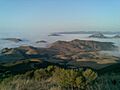
Santa Lucias in the clouds, near Santa Margarita.
-
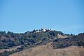
Hearst Castle was built atop Cuesta Ridge, the first ridgeline in from the ocean in that part of the Santa Lucia range.
-
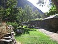
Tassajara Zen Mountain Center was built in the heart of the Santa Lucia range, in Monterey County.
-
Junipero Serra Peak is the highest point in the Santa Lucia Range.
