Cuyama River facts for kids
Quick facts for kids Cuyama River |
|
|---|---|

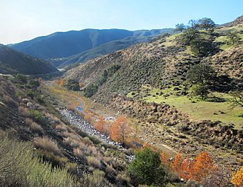
Cuyama River upstream of Twitchell Reservoir
|
|

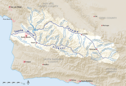
Map of the Santa Maria River watershed, including the Cuyama River
|
|
|
Location of the Cuyama River in California
|
|
| Country | United States |
| State | California |
| Physical characteristics | |
| Main source | Confluence of Alamo Creek and Dry Canyon Creek Near Ventucopa, Ventura County 3,807 ft (1,160 m) 34°41′25″N 119°17′33″W / 34.69028°N 119.29250°W |
| River mouth | Santa Maria River near Garey, San Luis Obispo and Santa Barbara Counties 354 ft (108 m) 34°54′11″N 120°18′45″W / 34.90306°N 120.31250°W |
| Length | 118 mi (190 km) |
| Basin features | |
| Basin size | 1,132 sq mi (2,930 km2) |
| Tributaries |
|
The Cuyama River is a river in California, about 118 miles (190 km) long. It flows through parts of San Luis Obispo, Santa Barbara, and Ventura Counties. This river is special because it joins with the Sisquoc River to form the Santa Maria River. The name "Cuyama" comes from the Chumash word kuyam. This word means "clam" or "freshwater mollusk".
Contents
Where the Cuyama River Flows
The Cuyama River starts high up in the San Emigdio Mountains. This area is part of the Chumash Wilderness within the Los Padres National Forest. The river's journey begins at an elevation of over 8,000 feet (2,400 meters).
River's Journey Through Counties
- Ventura County: The river's upper parts are in Ventura County. Here, several smaller streams, called tributaries, join the main river.
- Santa Barbara County: After leaving the national forest, the river enters Santa Barbara County. It then flows through the Cuyama Valley, which is about 45 miles (72 km) long.
- Cuyama Valley: The Cuyama Valley is located between the Caliente Range and the Sierra Madre Mountains. The river passes by the towns of Cuyama and New Cuyama.
- County Boundary: For much of its path through the Cuyama Valley and further downstream, the Cuyama River forms the natural border between Santa Barbara County and San Luis Obispo County.
Joining Other Rivers
Downstream from the Cuyama Valley, the river flows into Twitchell Reservoir. After leaving the reservoir, it travels another 6 miles (10 km). Then, it meets the Sisquoc River. When these two rivers join, they form the Santa Maria River. The Santa Maria River then flows for about 20 miles (32 km) until it reaches the Pacific Ocean.
How the River is Managed
The Cuyama River is managed to help control floods and store water. About 66 miles (106 km) from where it starts, the river reaches Twitchell Reservoir. This reservoir was created by building Twitchell Dam.
Twitchell Dam and Water Storage
- Flood Control: The dam helps prevent floods by holding back large amounts of water during heavy rains.
- Groundwater Recharge: Water is released slowly from the dam. This allows the water to soak into the ground. This process helps to refill the underground water supply, called the groundwater aquifer.
- Dry Periods: The reservoir is often empty, especially during the summer. This is because water is released as quickly as possible to help the ground absorb it. The river and reservoir are usually dry when there is little rain. However, big flows can happen after winter storms.
 | Dorothy Vaughan |
 | Charles Henry Turner |
 | Hildrus Poindexter |
 | Henry Cecil McBay |


