
Cuyama Valley facts for kids
Quick facts for kids Cuyama Valley |
|
|---|---|

Rugged terrain surrounding the Cuyama Valley
|
|

Location of the Cuyama Valley in southern and central California: green areas are national forests and national parks
|
|
| Area | 300 square miles (780 km2) |
| Geography | |
| Location | California, United States |
| Population centers | Cuyama, New Cuyama, Ventucopa |
| Traversed by | State Route 166, State Route 33 |
| Rivers | Cuyama River |
The Cuyama Valley is a long, flat area of land in central California. It's surrounded by mountains and is about a two-hour drive from big cities like Los Angeles and Santa Barbara. This valley stretches across parts of four different counties: Santa Barbara, San Luis Obispo, Kern, and Ventura.
Not many people live in the Cuyama Valley. Its main towns are Cuyama and New Cuyama, plus a smaller place called Ventucopa. Most of the land here is used for farming, raising animals (ranching), and getting oil and gas from the ground. Two important roads, State Route 166 and State Route 33, help connect the valley to other parts of California.
Contents
Cuyama Valley's Landscape
The Cuyama Valley covers about 300 square miles (777 square kilometers). It's like a big bowl surrounded by different mountain ranges. To the south and west are the Sierra Madre Mountains. The La Panza Range is to the north, and the Caliente Range is to the northeast. On the east side, you'll find the San Emigdio Mountains.
The Cuyama River starts in the mountains to the east and flows through the valley. The valley gets wider near where State Routes 166 and 33 meet, which is also where the four counties almost touch. As the river continues west, the valley narrows again before the river leaves through a canyon and eventually reaches the Pacific Ocean.
The best places for farming are in the middle of the valley, close to the main roads and towns. This area has rich soil because of the river's floods over time.
North of the valley, the Caliente Range rises, and beyond it is the Carrizo Plain, which is an even bigger valley. To the southeast, you can find high mountain areas, including Mount Pinos, one of the tallest peaks around. The very eastern part of the valley is crossed by the San Andreas Fault, a famous earthquake fault line.
Much of the land around the Cuyama Valley is part of the Los Padres National Forest. Other areas, especially in the Caliente Range, are managed by the U.S. Bureau of Land Management (BLM).
Valley's Ground and Rocks
The Cuyama Valley is like a big, long bowl filled with dirt and rocks carried by water. It sits about 2,000 to 2,500 feet (600 to 800 meters) above sea level. Most of the rocks here are sedimentary, meaning they formed from layers of sand, mud, and other materials over millions of years. You can see some of these old rocks, like the Monterey Formation, in the hills south of the valley. There are also interesting "badlands" in the upper parts of the valley, which are areas with deeply eroded, colorful hills.
Weather in the Valley
The Cuyama Valley has a dry climate with hot summers and cool winters. Most of the rain falls in winter, but it's not much—only about five inches (12.7 cm) per year on the valley floor. This makes it one of the driest places in coastal Central California! Sometimes it even snows, but that's rare. Because the valley is open towards the ocean, it occasionally gets some cool, moist air from the sea. The main plants growing on the valley floor are grasses and shrubs, with thicker brush and oak trees in the surrounding hills.
History of Cuyama Valley

The first people to live in the Cuyama Valley were the Chumash. The name "Cuyama" comes from a Chumash word, kuyam, which means "clam" or "freshwater mollusk." Besides Kuyam, other Chumash villages in the valley included Sxaliwilimu’, Lishawato’w, and Tsiwikon.
Even though Spanish explorers arrived in California in 1769, the Chumash in Cuyama Valley didn't have much contact with them until 1801. Between 1801 and 1822, over 400 people from the Cuyama Valley were baptized into Spanish missions. Many went to Mission La Purisima, while others joined Mission San Luis Obispo, Mission Santa Ines, and Mission Santa Barbara.
One important Cuyama Valley man was Pacomio, who was baptized at Mission La Purisima in 1803. The years from 1811 to 1822 were tough because Spain stopped supporting the missions. This meant native Christians had to work harder and pay taxes. So, the Cuyama Valley people joined mission life during a difficult time. In 1824, Pacomio became a leader in a big Chumash uprising that involved several missions.
In 1825, after Mexico became independent from Spain, a new governor in California allowed skilled native craftsmen to leave mission life. Pacomio became a free carpenter in Monterey, which was the capital of Mexican California. He even served on the town council! Sadly, he died in 1844 from smallpox.
Later, during the Mexican period, the valley was divided into two large land grants along the Cuyama River. These were Rancho Cuyama de Rojo (about 22,193 acres) in 1843, and Rancho Cuyama de Lataillade (about 48,827 acres) in 1846. For many years, the main activity was raising cattle. Some people also started small farms, especially in side canyons where there was more water. In 1939, the first successful water wells were drilled, which used pumps to bring up water from deep underground. This made it possible to grow many more crops, changing the valley into a farming area.
Not much else happened in the Cuyama Valley until oil was discovered. In 1948, oil was found at the Russell Ranch Oil Field, and even more was found in 1949 at the much larger South Cuyama Oil Field. Because of this, the Richfield Oil Company (which later became part of ARCO) built the town of New Cuyama. This town was created to house the oil workers and provide services for them. The oil from these fields was sent through pipelines to a refinery near Long Beach. For a short time in the early 1950s, the Cuyama Valley was the fourth-most productive oil region in California!
As oil production slowed down, farming became the main economic activity again. However, when oil prices went up around 2007 and 2008, companies became interested in looking for more oil in the valley. Recently, E&B Natural Resources bought the rights to develop the South Cuyama Oil Field.
Images for kids
-
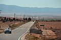
Cuyama seen from the east, on SR-166
-
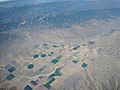
Cuyama, California aerial view showing farms and oil/gas field


