
Caliente Range facts for kids
Quick facts for kids Caliente Range |
|
|---|---|

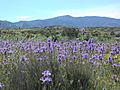
Caliente Range from the Carrizo Plain, with Caliente Peak at top center
|
|
| Highest point | |
| Elevation | 1,325 m (4,347 ft) |
| Geography | |

Location in California
|
|
| Country | United States |
| State | California |
| District | San Luis Obispo County |
| Range coordinates | 35°5′14.904″N 119°48′32.480″W / 35.08747333°N 119.80902222°W |
| Topo map | USGS Caliente Mountain |
The Caliente Range is a group of mountains in central California. They stretch from west to east and are part of the California Coast Ranges.
The tallest mountain in this range is Caliente Mountain. It's about 5,106 feet (1,556 m) high. You can find it in southeastern San Luis Obispo County.
Contents
What are the Caliente Mountains?
The Caliente Range is shaped like a big arch. Geologists call this an anticline. Its southern edge is a clear line made by the Morales Thrust Fault. The Cuyama River flows along this fault.
To the south, the Cuyama Valley separates the Caliente Range from the Sierra Madre Mountains. These are in nearby Santa Barbara County. To the northeast, you'll find the Carrizo Plain next to the range. To the northwest, the La Panza and Santa Lucia Ranges are nearby. These are also part of the Pacific Coast Ranges.
How the Mountains Formed
The rocks in the Caliente Range are mostly made of sand, mud, and other materials. These were laid down by oceans and on land over the last 30 million years. There are also some volcanic rocks mixed in. You can see these especially in the foothills near the Carrizo Plain. These volcanic rocks are from a time called the Tertiary period. Most of them are a type of dark rock called basalt.
Who Owns the Land?
Most of the Caliente Range is public land. It is owned and managed by the Bureau of Land Management. Some parts are privately owned. Also, some of the foothills in the northeast are protected. They are part of the Carrizo Plain National Monument.
Getting to the Peak
You can reach the highest peak by walking or biking on a special road. This road is usually closed to cars. There's an old cabin skeleton at the top of the peak. This cabin was a lookout point during World War II. Observers there could see and report Japanese airplanes. They were watching for planes that might try to bomb important oil fields in Kern County.
The trip to the lookout point and back is about 17 miles (27 km) long. You'll go up and down about 2,700 feet (820 m) in elevation along the way.
Weather in the Caliente Range
The higher parts of the mountains get more rain and snow than the lower areas. This happens because of something called orographic lift. When storms pass over the mountains, the air is forced upwards. This makes the air cool down and drop its moisture as rain or snow. Some snow falls on the very highest parts of the range.
Images for kids
-
Caliente Range from the Carrizo Plain, with Caliente Peak at top center
