
California Coast Ranges facts for kids
Quick facts for kids California Coast Range |
|
|---|---|

Santa Lucia Range
|
|
| Highest point | |
| Peak | Mount Linn |
| Elevation | 8,098 ft (2,468 m) |
| Dimensions | |
| Length | 400 mi (640 km) |
| Geography | |
| Country | United States |
| State | California |
| Parent range | Pacific Coast Ranges |
The California Coast Ranges are a long chain of mountains in California. They stretch for about 400 miles (640 km) along the coast, from northern California near Del Norte and Humboldt County, California all the way south to Santa Barbara County. These mountains are part of a bigger group called the Pacific Coast Ranges.
California has other coastal mountain ranges too, like the Transverse Ranges, Peninsular Ranges, and Klamath Mountains. The Coast Ranges are also part of a special area recognized by UNESCO since 1983. It's called the "California Coast Ranges Biosphere Reserve" and is part of the World Network of Biosphere Reserves. This means it's a place where people try to balance nature conservation with human activities.
Contents
How the Coast Ranges Formed

The California Coast Ranges start in the north, where they meet the Klamath Mountains. They go south for over 600 miles (970 km) until the coastline turns east near Point Conception. Here, they meet the Transverse Ranges, which are sometimes called the Sierras de los Angeles.
The rocks that make up these mountains are very old and diverse. Most of them formed during the Tertiary, Cretaceous, and Jurassic periods. Many of these rocks were once soft sediments at the bottom of the sea. Over time, molten rock (lava) pushed its way into cracks and gaps in these sediments.
All of the Coast Ranges have been pushed and squeezed, causing the rock layers to fold and fault (break). This happened many times over millions of years. Softer rocks wore away due to erosion, giving the mountains their current look.
Mercury Mining in the Mountains
The California Coast Ranges had a lot of mercury mining, especially after gold was found in the Sierra Nevada. For example, near Clear Lake, there were many deposits of a mineral called cinnabar, which contains mercury. These deposits were linked to volcanoes and shifting land plates.
In 1877, these mines produced a huge amount of mercury, about 2,776 metric tons. Today, these old, unused mines can still cause pollution. Water running off from them can carry mercury into Cache Creek and other rivers.
Northern Coast Ranges
The Northern Coast Ranges are a major part of the California Coast Ranges. They run along the Pacific Coast from the North San Francisco Bay Area up to Del Norte County. To the north and northeast are the Klamath Mountains. To the south are the Southern Coast Ranges.

Northern Geography
The Northern Coast Ranges generally run north-south, parallel to the coast. Some of the smaller mountain chains within them include the Mendocino Range, Mayacamas, Sonoma, and Vaca Mountains. The Marin Hills are also part of this area.
The King Range is another important part. It meets the ocean in a wild area known as the "Lost Coast". The southernmost point of the Northern Coast Ranges is Mount Tamalpais.
The highest point in the Northern Coast Ranges is Mount Linn, which stands at 8,098 feet (2,468 meters) tall.
Outer and Inner Ranges
The Northern Coast Ranges are made up of two main parallel lines of mountains. The Outer Northern Coast Ranges are right along the coast. The Inner Northern Coast Ranges are further inland to the east. A long system of valleys separates these two mountain belts.
The northern part of these valleys is drained by the Eel River. The southern part is drained by the Russian River. Shorter rivers like the Mattole, Gualala, and Navarro flow down the western slopes of the ranges into the ocean. The eastern slopes drain into the Sacramento Valley. Clear Lake is in the southeast part of the range and flows east into Cache Creek.
U.S. Route 101 is a major highway that runs generally north-south through the valleys between the Outer and Inner Northern Coast Ranges.
Northern Nature
The side of the Outer Northern Coast Ranges facing the ocean is covered in lush forests. This area is part of the Northern California coastal forests ecoregion. It's home to giant Coast Redwood trees and tall Coast Douglas-fir trees.
The Inner Northern Coast Ranges are drier and are part of the California chaparral and woodlands ecoregion. Here, you can find different plant groups like mixed evergreen forests, oak woodlands, and chaparral. A special type of forest in the inner ranges is the Mediterranean California Lower Montane Black Oak-Conifer Forest. This forest has a lot of different plants and animals, including the California Black Oak.
Columbian Black-tailed Deer are the most common large mammals in the Northern Coast Ranges, besides humans. The rivers in these mountains are also home to several types of salmon.
Southern Coast Ranges

The Southern Coast Ranges are another important part of the California Coast Ranges. They also run north and south, parallel to the Pacific Coast, in central and southern California. They start on the San Francisco Peninsula and in the East San Francisco Bay Area. From there, they stretch south into Santa Barbara County. The Transverse Ranges are to their south. The San Joaquin Valley is to the east, and the Pacific Ocean is to the west.
Southern Geography
The Southern Coast Ranges include several well-known mountain chains. These are the Berkeley Hills, the Diablo Range, the Santa Cruz Mountains, the Gabilan Range, the Santa Lucia Range and Sierra de Salinas, the Temblor Range, and the Sierra Madre Mountains.
Just like the Northern Coast Ranges, there are Outer Southern Coast Ranges along the Pacific Ocean and Inner Southern Coast Ranges further inland. The central and southern San Francisco Bay and the Salinas Valley are located between these two belts of mountains.
The highest point in the Southern Coast Ranges is Junipero Serra Peak in the Santa Lucia Range, which is 5,862 feet (1,787 meters) tall. Other notable peaks include Mount Diablo at 3,849 feet (1,173 meters) and Mount Hamilton at 4,196 feet (1,279 meters).
Southern Nature
The Southern Coast Ranges mostly have a Mediterranean climate, which means they have warm, dry summers and mild, wet winters. Most of this area is part of the California chaparral and woodlands ecoregion. However, the wetter parts of the Santa Cruz Mountains are home to Coast redwood forests, similar to those in northern California. You can also find isolated groups of Coast redwoods in the Big Sur area of the Santa Lucia Range. These are the southernmost natural redwoods in the world.
Some very rare forests in the California Coast Ranges are the Maritime Coast Range Ponderosa Pine forests in the western Santa Cruz Mountains. These special groves can include Ponderosa pine, Douglas fir, and knobcone pine.
Interestingly, the highest parts of the Santa Lucias have small patches of Sierran Conifer forest. These include trees like Incense Cedar, and Ponderosa, Jeffrey, and Sugar Pines. The steep, rocky slopes are home to the unique Santa Lucia Fir, which is the rarest type of fir tree on Earth.
The California chaparral and woodlands ecoregion in the Southern Coast Ranges has many different plant groups. These include mixed evergreen forests, oak woodlands, grasslands, and coastal scrub. The name "chaparral" comes from a Spanish word for a type of scrub oak.
Common trees in the oak woodlands include different kinds of oaks, California bay, and buckeye. Along rivers, you can find trees like sycamore, White alder, willows, and Big-Leaf Maple.
Columbian Black-tailed Deer live in the northern and more coastal parts of the Southern Coast Ranges. California mule deer are found in the inland and southernmost areas.
Mountain Ranges
Images for kids
-
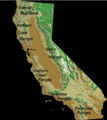
Northern and Southern Coast Ranges and other major mountain ranges of California

See also
 In Spanish: Cordillera costera de California para niños
