Vaca Mountains facts for kids
Quick facts for kids Vaca Mountains |
|
|---|---|

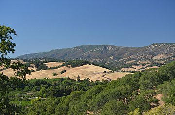
Mt. Vaca and the Blue Ridge, high points of Solano County, as seen from upper Suisun Valley.
|
|
| Highest point | |
| Peak | Mount Vaca |
| Elevation | 859 m (2,818 ft) |
| Geography | |
| Country | United States |
| State | California |
| Region | Napa County, Solano County |
| Range coordinates | 38°24′01″N 122°06′22″W / 38.4001881°N 122.1060815°W |
| Topo map | USGS Mount Vaca |
The Vaca Mountains are a mountain range in Napa and Solano Counties, California. They are part of the California Coast Ranges. These mountains are the easternmost part of the Inner Coast Ranges in north-central California. They separate the Suisun Valley to their west from the Sacramento Valley to their east.
Contents
Exploring the Vaca Mountains: Geography
The Vaca Mountains are a very noticeable feature in Solano County. The east side has a steep ridge that rises sharply over 300 meters (1,000 feet). The range starts near Suisun Marsh in a wide, low area. This area also includes the city of Fairfield and Travis Air Force Base. It separates the Vaca Mountains from some smaller hills called the Montezuma Hills.
The Vaca Mountains stretch about 28 kilometers (17.5 miles) north. They end at Putah Creek Canyon. The mountains are about 9 kilometers (5.5 miles) wide on average. Most of their 250 square kilometers (61,775 acres) is natural land. Mount Vaca is the highest point at 859 meters (2,818 feet). It is also the highest spot in Solano County. The main part of the range is called the Blue Ridge. This ridge stays above 580 meters (1,900 feet) for many kilometers.
The Blue Ridge seems to end at Putah Creek Canyon. But the mountains continue on the north side of the canyon as the Blue Ridge Range. This area looks and is geologically similar to the Vaca Mountains. From most places on the east side, it's hard to see the canyon. So, the Vaca and Blue Ridge Mountains look like one long ridge. This ridge marks the western edge of the Sacramento Valley. The Sacramento Valley is the northern half of California's 640-kilometer (400-mile) long Central Valley.
Climate and Nature in the Vaca Mountains
The Vaca Mountains have a typical California climate. They have a cool, wet season from November to April. This is followed by a warm, dry season. Because the Vacas are the easternmost Coast Ranges, they get less rain. This is due to a "rain shadow" effect. Mountains to the west, like the Mayacamas Mountains, are closer to the Pacific Ocean and get more rain.
The Vaca Mountains usually get 635 to 762 millimeters (25 to 30 inches) of rain each year. Almost all of this rain falls during the wet season. Snow sometimes falls on Mt. Vaca and Blue Ridge during very cold winters. But it rarely snows on the lower parts of the mountains. Temperatures range from 4 to 10 degrees Celsius (40 to 50 degrees Fahrenheit) in the wet season. They can go over 38 degrees Celsius (100 degrees Fahrenheit) in the dry season. Since most rain falls in winter, there is a high risk of fires in the hot summers and early fall.
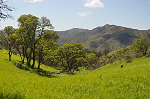
The good winter rainfall helps many different plants grow here. You can find chaparral plants like chamise, buckbrush (Ceanothus), and manzanita (Arctostaphylos) on the ridges. The slopes have grasslands with oak trees (Quercus) and poison oak (Toxicodendron). In canyons with streams that flow all year, you'll find riparian habitats. Because the land is steep, it is mostly undeveloped. This means the native plants are largely undisturbed. However, there is some farming in the lower hills. Wine grapes grow on the western slopes (Solano County side). Fruit and nut trees grow on the eastern slopes (Yolo County side).
How the Vaca Mountains Were Formed: Geology
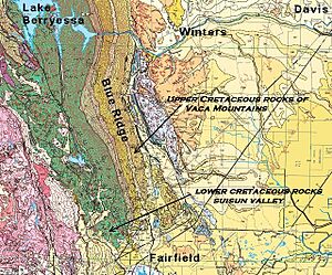
Most of the Vaca Mountains are made of sedimentary rocks. These rocks are from the Cretaceous period, which was 65 to 145 million years ago. These rocks are mostly shale and sandstone layers. Scientists believe they formed deep in the ocean. They were created from sediment washed down from the ancient Sierra Nevada mountains. There are also some conglomerate rocks. These might be from old underwater canyons.
The layers of rock in the Vaca Mountains run parallel to the mountain crest. They tilt down towards the east. This has caused the mountains to have a steep western side. The eastern side has a much gentler slope.
You can also find black basalt rocks in some places. These are called the Putnam Peak Basalt. They are found near Vacaville in the south, at Putnam Peak in the middle, and in Putah Creek Canyon in the north. These basalt rocks are much younger, about 15-16 million years old. This means they are from the Miocene age. Scientists think they are what's left of an ancient volcanic eruption. A very runny flow of lava spread across a large part of central California from the east side of the Sierra Nevada.
Water in the Vaca Mountains
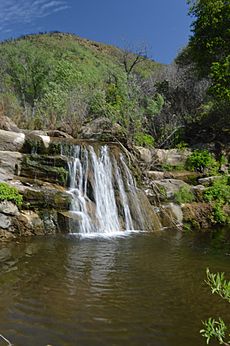
The Vaca Mountains have several streams that flow all year. The most important ones are Suisun Creek on the west side and Putah Creek on the east.
In 1926, the city of Vallejo, California built a dam at the north end of Suisun Creek. This created the Lake Curry reservoir, which held about 13 million cubic meters (10,700 acre-feet) of water. It was used for city water until 1992.
The Monticello Dam and Lake Berryessa reservoir were built on Putah Creek in 1957-1958. This project also included the Putah South Canal. This system can store over 100 times more water than Lake Curry. It provides water for many farms, vineyards, and orchards today.
History of the Vaca Mountains
The first people to live in the Vaca Mountains were the Patwin people. The mountains are named after the Vaca family. The city of Vacaville is also named after them. The Vaca family, along with the Pena family, were some of the first European settlers in the area. In 1843, they received a large land grant from Mexico. This grant, called Rancho Los Putos, covered about 17,966 hectares (44,385 acres). It included most of the southern part of the Vaca Mountains.
In August 2020, a large wildfire called the Hennessey Fire started in the Vaca Mountains near Lake Hennessey. This fire burned over 127,470 hectares (315,000 acres) across five counties.
 | Shirley Ann Jackson |
 | Garett Morgan |
 | J. Ernest Wilkins Jr. |
 | Elijah McCoy |


