Monticello Dam facts for kids
Quick facts for kids Monticello Dam |
|
|---|---|
 |
|
| Location | Vaca Mountains, Napa County, California. |
| Coordinates | 38°30′48″N 122°06′15″W / 38.5133°N 122.1042°W |
| Construction began | 1953 |
| Opening date | 1957 |
| Operator(s) | Bureau of Reclamation |
| Dam and spillways | |
| Impounds | Putah Creek |
| Height | 304 ft (93 m) |
| Length | 1,023 ft (312 m) |
| Width (base) | 100 ft (30 m) |
| Reservoir | |
| Creates | Lake Berryessa |
| Total capacity | 1,602,000 acre⋅ft (1.976×10⁹ m3) |
| Catchment area | 566 sq mi (1,470 km2) |
| Surface area | 20,700 acres (8,400 ha) |
| Power station | |
| Operator(s) | Solano Irrigation District |
| Commission date | 1983 |
| Turbines | 2 × 5 MW, 1 × 1.5 MW |
| Installed capacity | 11.5 MW |
| Annual generation | 56,806,000 KWh (2004) |
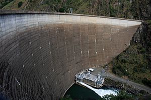
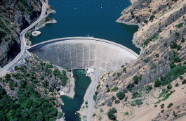
The Monticello Dam is a large concrete arch dam in Napa County, California. It stands 304-foot (93 m) tall and was built between 1953 and 1957. This dam holds back the Putah Creek to create Lake Berryessa in the Vaca Mountains.
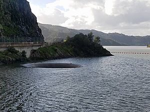
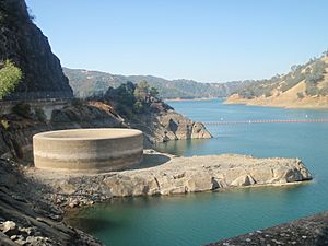
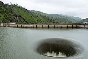
Lake Berryessa is one of the largest man-made lakes in California. The water from this lake mainly helps farms in the Sacramento Valley. The dam is famous for its special "morning-glory-type" spillway. This spillway looks like a giant funnel and is 72 ft (22 m) wide at the top. People often call it the "Glory Hole."
To the south of the dam is the Putah Creek State Wildlife Area.
Contents
Facts About Monticello Dam
The Monticello Dam and its 26-mile (42 km) long lake are mostly in eastern Napa County. However, the dam is very close to the border with Yolo County. Also, some of the lake's watershed (the area that collects water for the lake) reaches into Lake County.
Monticello Dam is a concrete arch dam. It is 304 ft (93 m) high from its base and 1,023 ft (312 m) long. The dam is 100 ft (30 m) thick at the bottom and gets thinner towards the top, where it is 12 ft (3.7 m) thick.
The lake, Lake Berryessa, can hold a lot of water, about 1,602,000 acre⋅ft (1.976×10⁹ m3). Its surface area is 20,700 acres (8,400 ha) when full. Water flows into the lake from a 566-square-mile (1,470 km2) watershed.
Power Generation at the Dam
The Monticello Dam Powerplant was finished in 1983. It has three generators that can make a total of 11.5 megawatts (MW) of electricity. The Solano Irrigation District runs and takes care of this power plant. The electricity mainly goes to the North Bay area of the San Francisco Bay Area.
Water for Farms and Cities
The dam helps irrigate (water) many farms. Water is taken from the Putah Creek about 6 miles (9.7 km) downstream from the dam. This water then travels through the 33-mile (53 km) Putah South Canal to reach farms. The canal also supplies water to the cities of Vallejo and Benicia. The dam project also helps prevent floods, saving a lot of money over the years.
History of the Dam
The Monticello Dam was built as part of the Solano Project. This project aimed to provide a steady water supply for farms in Solano County and Yolo County. Farmers in these areas had been working the land since the 1840s. However, they needed a reliable water source during the dry summer months.
The area where the dam and lake are now was once called Rancho Las Putas. It was a large land grant given in 1843 to José and Sixto Berryessa, whose name is now used for the lake. Before the dam was built, this valley was a very fertile farming area. It even had a town called Monticello with about 250 people.
Planning and Building the Dam
The idea for the Solano Project started in the 1940s. The Bureau of Reclamation, a government agency, was put in charge of building it. At first, they thought about making it part of a bigger project called the Central Valley Project. But local people wanted the Solano Project to be separate. In 1953, it was decided that Solano would be its own project.
Land for the future lake area was bought in 1953. People living there were allowed to stay until the water started to rise. Many people in the Berryessa Valley did not want the dam built. The nearby city of Winters also opposed it because of their ties to Monticello. Some suggested building smaller reservoirs instead, but this was not seen as a good idea. Most residents of Monticello moved out by 1956 as the water got closer. Before the area was flooded, crews cleared the valley and tore down buildings. About 300 graves also had to be moved to higher ground.
Construction of the main dam began in 1954. The first concrete was poured in August 1955. Even with some major floods in 1956, most of the concrete was in place by December 1956. The dam was finished on November 7, 1957. The total cost was about $37 million, which included other related water projects and moving a highway.
Lake Berryessa Forms
It took five years for the lake to fill up after the dam was built. Lake Berryessa reached its full capacity for the first time on April 18, 1963. The lake completely covered the town of Monticello. You can sometimes see the old town's ruins when the water level is low. Lake Berryessa became the second-largest reservoir in California at that time.
The Bureau of Reclamation runs five recreation areas around the lake. These areas have boat ramps and places for day trips. The number of visitors has gone down since 2012. This is partly because some local resorts closed to help with pollution and to upgrade the lake. In the past, as many as 1.3 million people visited the lake each year.
The Glory Hole Spillway
The dam's special spillway, called the Glory Hole, is 72 feet (22 m) wide at the lake's surface. It narrows down to about 28 feet (8.5 m) at its exit. When the lake is at its highest level, the spillway can drain 48,400 cubic feet per second (1,370 m3/s) of water. This happens when the lake level rises 15.5 feet (4.7 m) above the funnel's edge.
Water starts to flow into the Glory Hole when the lake reaches 1,602,000 acre-feet (1.976×10⁹ m3) of water. This is when the lake's elevation is 440 feet (130 m) above sea level. The last time the lake naturally spilled through the Glory Hole was on February 26, 2019.
Before that, it was active on February 16, 2017. People were very excited to see it, and some boaters even made waves to help the water spill briefly on February 13, 2017. The lake then naturally filled and spilled into the Glory Hole on February 16, 2017.
You can check the current lake level status at the Solano County Water Agency website.
It is very important to know that swimming near the Glory Hole is forbidden. The strong currents around it are very dangerous.
Environmental Effects
The Monticello Dam has changed the environment around Putah Creek. Studies have shown that the dam affects how groundwater is refilled and how sandbars form. It also changed the riverbed, which affected plants like cottonwood and willow trees.
See also
 In Spanish: Represa Monticello para niños
 | Bayard Rustin |
 | Jeannette Carter |
 | Jeremiah A. Brown |


